The BN13 2 postcode sector is within the county of West Sussex.
Did you know? According to the 2021 Census, the BN13 2 postcode sector is home to a bustling 10,711 residents!
Given that each sector allows for 400 unique postcode combinations. Letters C, I, K, M, O and V are not allowed in the last two letters of a postcode. With 249 postcodes already in use, this leaves 151 units available.
The BN13 2 postal code covers the settlement of WORTHING.
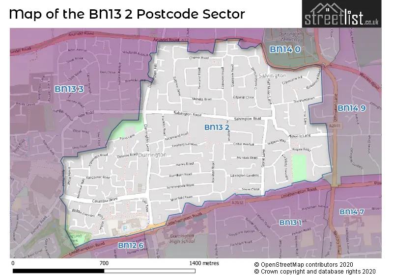
The BN13 2 Postcode shares a border with BN13 3 (WORTHING, Patching, Clapham), BN14 0 (WORTHING, Findon), BN14 9 (WORTHING), BN12 6 (Goring-by-Sea, Ferring) and BN13 1 (WORTHING).
The sector is within the post town of WORTHING.
BN13 2 is a postcode sector within the BN13 postcode district which is within the BN Brighton postcode area.
The Royal Mail delivery office for the BN13 2 postal sector is the Worthing Delivery Office.
The area of the BN13 2 postcode sector is 0.78 square miles which is 2.03 square kilometres or 500.67 square acres.
The BN13 2 postcode sector is crossed by the A27 Major A road.

Map of the BN13 2 Postcode Sector
Explore the BN13 2 postcode sector by using our free interactive map.
| B | N | 1 | 3 | - | 2 | X | X |
| B | N | 1 | 3 | Space | 2 | Letter | Letter |
Official List of Streets
WORTHING (131 Streets)
Unofficial Streets or Alternative Spellings
WORTHING
BRAMBLE LANE CROCKHURST HILL MILL LANE NEW ROAD ROMANY ROAD UPLANDS AVENUE VICARAGE FIELDS WHYLANDS AVENUE ASHACRE MEWS CURZON CLOSE DURRINGTON ROUNDABOUT EAST TYNE GREENLAND MEWS HAMMOND CLOSE KINGSBRIDGE MEWS LITTLE GABLES LITTLESTONE ROAD MIDDLE TYNE OFFINGTON CORNER ROUNDABOUT PALM COURT POND MEWS SANDRINGHAM MEWS SELDENS MEWS WALTON LODGE WEST TYNEFerring
LITTLEHAMPTON ROADAngmering
ARUNDEL ROADSchools and Places of Education Within the BN13 2 Postcode Sector
Durrington Infant School
Community school
Salvington Road, Worthing, West Sussex, BN13 2JD
Head: Mrs Sara Ensor
Ofsted Rating: Requires improvement
Inspection: 2023-06-21 (350 days ago)
Website: Visit Durrington Infant School Website
Phone: 01903260138
Number of Pupils: 296
Durrington Junior School
Community school
Salvington Road, Worthing, West Sussex, BN13 2JD
Head: Mrs Zoe Wilby
Ofsted Rating: Good
Inspection: 2022-06-22 (714 days ago)
Website: Visit Durrington Junior School Website
Phone: 01903260761
Number of Pupils: 303
House Prices in the BN13 2 Postcode Sector
| Type of Property | 2018 Average | 2018 Sales | 2017 Average | 2017 Sales | 2016 Average | 2016 Sales | 2015 Average | 2015 Sales |
|---|---|---|---|---|---|---|---|---|
| Detached | £367,727 | 48 | £370,238 | 46 | £346,924 | 40 | £310,216 | 59 |
| Semi-Detached | £298,038 | 69 | £290,206 | 72 | £288,359 | 65 | £264,220 | 90 |
| Terraced | £260,261 | 57 | £258,468 | 53 | £249,710 | 39 | £220,281 | 81 |
| Flats | £164,214 | 21 | £161,376 | 42 | £145,511 | 17 | £150,156 | 34 |
Important Postcodes BN13 2 in the Postcode Sector
BN13 2JD is the postcode for Worthing West Family Hub, 81 Salvington Road, MAIN BUILDING, Durrington Infant School, Salvington Road, West Sussex County Council, Durrington Library, 85 Salvington Road, GARDEN ROOMS, Durrington Infant School, Salvington Road, Durrington Junior School, Salvington Road, NEW BLOCK, Durrington Junior School, Salvington Road, Durrington Children & Family Centre, 81 Salvington Road, MAIN BUILDING, Durrington Junior School, Salvington Road, and Durrington Infant School, Salvington Road
BN13 2PQ is the postcode for Sussex Police, Centenary House, Durrington Lane
BN13 2QB is the postcode for West Sussex County Council, Centenary House, Durrington Lane
BN13 2QJ is the postcode for MAY HOUSE, 6, Durrington Lane
BN13 2RX is the postcode for Durrington Health Centre, Durrington Lane
BN13 2TF is the postcode for New Tyne Resource Centre, Durrington Lane
| The BN13 2 Sector is within these Local Authorities |
|
|---|---|
| The BN13 2 Sector is within these Counties |
|
| The BN13 2 Sector is within these Water Company Areas |
|