The BN13 3 postcode sector is within the county of West Sussex.
Did you know? According to the 2021 Census, the BN13 3 postcode sector is home to a bustling 10,884 residents!
Given that each sector allows for 400 unique postcode combinations. Letters C, I, K, M, O and V are not allowed in the last two letters of a postcode. With 304 postcodes already in use, this leaves 96 units available.
The largest settlement in the BN13 3 postal code is WORTHING followed by Patching, and Clapham.
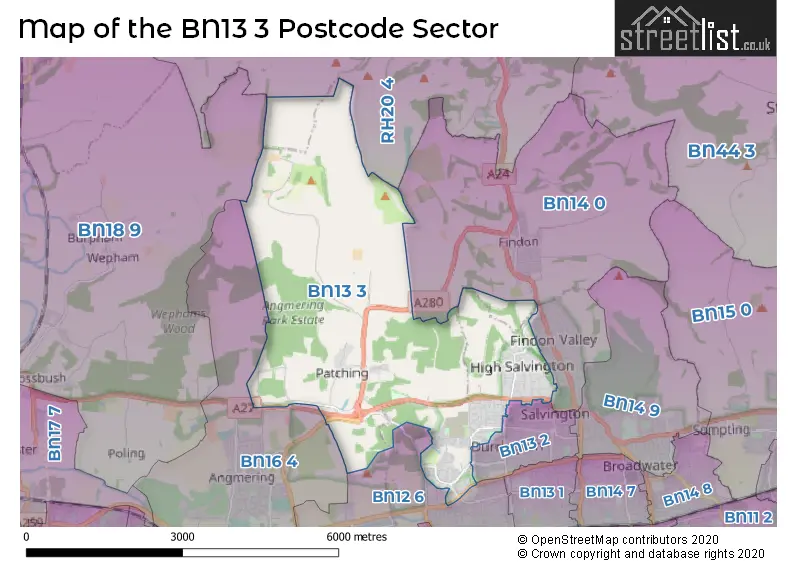
The BN13 3 Postcode shares a border with BN14 0 (WORTHING, Findon), BN16 4 (Angmering), RH20 4 (Storrington, Washington, Cootham), BN12 6 (Goring-by-Sea, Ferring), BN13 2 (WORTHING) and BN18 9 (ARUNDEL, Amberley, Poling).
The sector is within the post town of WORTHING.
BN13 3 is a postcode sector within the BN13 postcode district which is within the BN Brighton postcode area.
The Royal Mail delivery office for the BN13 3 postal sector is the Worthing Delivery Office.
The area of the BN13 3 postcode sector is 9.27 square miles which is 24.01 square kilometres or 5,933.65 square acres.
The BN13 3 postcode sector is crossed by the A27 Major A road.

Map of the BN13 3 Postcode Sector
Explore the BN13 3 postcode sector by using our free interactive map.
| B | N | 1 | 3 | - | 3 | X | X |
| B | N | 1 | 3 | Space | 3 | Letter | Letter |
Official List of Streets
WORTHING (197 Streets)
Castle Goring (4 Streets)
Clapham (10 Streets)
Patching (12 Streets)
Unofficial Streets or Alternative Spellings
WORTHING
CHEVIOT CLOSE COTSWOLD CLOSE COTSWOLD ROAD DURRINGTON HILL ELM MEWS POND LANEGoring-by-Sea
SKYLARK RISE TITNORE LANEFerring
LITTLEHAMPTON ROAD BLENHIEM COURT BLUNDENS RIDE CLAPHAM BICYCLE TRACK DAPPERS LANE ELIZABETH MEWS FOXLEY WAY GLADIOLUS DRIVE GRUB RIDE HAWTHORNS MYRTLE GROVE FARM POT LANE SOUTHERN WATER TASMAN WAY THE GALLOPS WINDY RIDGE WOODLANDS CLOSE YEOMAN GATE ZIANNA ROWAngmering
ARUNDEL ROAD WATER LANEStorrington
CHANTRY LANEWeather Forecast for BN13 3
Press Button to Show Forecast for Chanctonbury Hill
| Time Period | Icon | Description | Temperature | Rain Probability | Wind |
|---|---|---|---|---|---|
| 15:00 to 18:00 | Overcast | 6.0°C (feels like 2.0°C) | 11.00% | E 13 mph | |
| 18:00 to 21:00 | Overcast | 6.0°C (feels like 2.0°C) | 11.00% | E 16 mph | |
| 21:00 to 00:00 | Heavy rain | 5.0°C (feels like 1.0°C) | 85.00% | E 18 mph |
Press Button to Show Forecast for Chanctonbury Hill
| Time Period | Icon | Description | Temperature | Rain Probability | Wind |
|---|---|---|---|---|---|
| 00:00 to 03:00 | Heavy rain | 5.0°C (feels like 1.0°C) | 88.00% | ENE 18 mph | |
| 03:00 to 06:00 | Light rain | 5.0°C (feels like 1.0°C) | 56.00% | ENE 18 mph | |
| 06:00 to 09:00 | Drizzle | 6.0°C (feels like 1.0°C) | 48.00% | ENE 16 mph | |
| 09:00 to 12:00 | Mist | 8.0°C (feels like 5.0°C) | 53.00% | ENE 11 mph | |
| 12:00 to 15:00 | Cloudy | 11.0°C (feels like 8.0°C) | 34.00% | ESE 11 mph | |
| 15:00 to 18:00 | Cloudy | 10.0°C (feels like 8.0°C) | 15.00% | E 9 mph | |
| 18:00 to 21:00 | Heavy rain | 9.0°C (feels like 6.0°C) | 89.00% | NE 18 mph | |
| 21:00 to 00:00 | Heavy rain | 8.0°C (feels like 4.0°C) | 91.00% | NE 20 mph |
Press Button to Show Forecast for Chanctonbury Hill
| Time Period | Icon | Description | Temperature | Rain Probability | Wind |
|---|---|---|---|---|---|
| 00:00 to 03:00 | Heavy rain | 8.0°C (feels like 4.0°C) | 91.00% | NE 16 mph | |
| 03:00 to 06:00 | Heavy rain | 8.0°C (feels like 4.0°C) | 93.00% | E 16 mph | |
| 06:00 to 09:00 | Heavy rain | 8.0°C (feels like 5.0°C) | 81.00% | WSW 11 mph | |
| 09:00 to 12:00 | Heavy rain | 7.0°C (feels like 3.0°C) | 83.00% | W 16 mph | |
| 12:00 to 15:00 | Overcast | 8.0°C (feels like 4.0°C) | 24.00% | W 18 mph | |
| 15:00 to 18:00 | Cloudy | 9.0°C (feels like 6.0°C) | 12.00% | W 13 mph | |
| 18:00 to 21:00 | Cloudy | 9.0°C (feels like 6.0°C) | 9.00% | WSW 13 mph | |
| 21:00 to 00:00 | Partly cloudy (night) | 7.0°C (feels like 4.0°C) | 4.00% | SW 13 mph |
Press Button to Show Forecast for Chanctonbury Hill
| Time Period | Icon | Description | Temperature | Rain Probability | Wind |
|---|---|---|---|---|---|
| 00:00 to 03:00 | Partly cloudy (night) | 6.0°C (feels like 3.0°C) | 5.00% | SW 9 mph | |
| 03:00 to 06:00 | Partly cloudy (night) | 5.0°C (feels like 2.0°C) | 2.00% | SW 9 mph | |
| 06:00 to 09:00 | Partly cloudy (day) | 7.0°C (feels like 4.0°C) | 1.00% | S 9 mph | |
| 09:00 to 12:00 | Partly cloudy (day) | 10.0°C (feels like 7.0°C) | 1.00% | S 11 mph | |
| 12:00 to 15:00 | Partly cloudy (day) | 11.0°C (feels like 8.0°C) | 2.00% | S 13 mph | |
| 15:00 to 18:00 | Sunny day | 11.0°C (feels like 9.0°C) | 2.00% | S 11 mph | |
| 18:00 to 21:00 | Sunny day | 11.0°C (feels like 9.0°C) | 1.00% | SSE 9 mph | |
| 21:00 to 00:00 | Clear night | 8.0°C (feels like 5.0°C) | 1.00% | SE 11 mph |
Press Button to Show Forecast for Chanctonbury Hill
| Time Period | Icon | Description | Temperature | Rain Probability | Wind |
|---|---|---|---|---|---|
| 00:00 to 03:00 | Clear night | 8.0°C (feels like 5.0°C) | 2.00% | ESE 13 mph | |
| 03:00 to 06:00 | Clear night | 7.0°C (feels like 4.0°C) | 3.00% | ESE 13 mph | |
| 06:00 to 09:00 | Sunny day | 8.0°C (feels like 5.0°C) | 3.00% | ESE 13 mph | |
| 09:00 to 12:00 | Partly cloudy (day) | 11.0°C (feels like 9.0°C) | 4.00% | SE 11 mph | |
| 12:00 to 15:00 | Partly cloudy (day) | 13.0°C (feels like 11.0°C) | 6.00% | SE 13 mph | |
| 15:00 to 18:00 | Partly cloudy (day) | 14.0°C (feels like 11.0°C) | 6.00% | SE 11 mph | |
| 18:00 to 21:00 | Cloudy | 12.0°C (feels like 10.0°C) | 10.00% | SE 11 mph | |
| 21:00 to 00:00 | Partly cloudy (night) | 10.0°C (feels like 7.0°C) | 8.00% | ESE 11 mph |
Schools and Places of Education Within the BN13 3 Postcode Sector
Clapham and Patching CofE Primary School
Academy converter
The Street, Worthing, West Sussex, BN13 3UU
Head: Mrs Justine Chubb
Ofsted Rating: Requires improvement
Inspection: 2023-09-20 (219 days ago)
Website: Visit Clapham and Patching CofE Primary School Website
Phone: 01903871214
Number of Pupils: 45
The Laurels Primary School, Worthing
Academy converter
Winterbourne Way, Worthing, West Sussex, BN13 3QH
Head: Miss Charlotte Bull
Ofsted Rating: Good
Inspection: 2022-10-20 (554 days ago)
Website: Visit The Laurels Primary School, Worthing Website
Phone: 01903830901
Number of Pupils: 184
House Prices in the BN13 3 Postcode Sector
| Type of Property | 2018 Average | 2018 Sales | 2017 Average | 2017 Sales | 2016 Average | 2016 Sales | 2015 Average | 2015 Sales |
|---|---|---|---|---|---|---|---|---|
| Detached | £407,984 | 164 | £408,031 | 79 | £402,732 | 94 | £405,791 | 77 |
| Semi-Detached | £309,741 | 96 | £318,690 | 105 | £290,608 | 83 | £272,290 | 30 |
| Terraced | £286,442 | 36 | £283,542 | 33 | £268,991 | 64 | £230,569 | 21 |
| Flats | £219,064 | 14 | £170,828 | 9 | £196,141 | 11 | £163,238 | 4 |
Important Postcodes BN13 3 in the Postcode Sector
BN13 3BW is the postcode for Salvington Lodge, Salvington Hill, and The Burrows, Salvington Lodge
BN13 3EF is the postcode for Meadowfield Mental Health Block, Swandean, 85 Arundel Road
BN13 3EP is the postcode for Sussex Partnership NHS Foundation Trust, Selden Centre, CHANCTONBURY, Trust Headquarters, Arundel Road, Sussex Partnership NHS Trust, Meadowfield, Meadowfield, Arundel Road, NORTHDOWN/SOUTHDOWN, Sussex Partnership NHS Trust, Trust Headquarters, Trust Headquarters, Arundel Road, Western Region Locality Office, Arundel Road, and HIGHDOWN, Trust Headquarters, Arundel Road
BN13 3EZ is the postcode for The Hawthorns School, Poplar Road, and Stanhope Lodge, 17 Poplar Road
BN13 3FJ is the postcode for Durrington Community Centre, 2 Romany Road
BN13 3QH is the postcode for The Laurels Primary School, Winterbourne Way, and County First School, Winterbourne Way
BN13 3RB is the postcode for Adult Education Centre, The Pines, Faraday Close
BN13 3UU is the postcode for Clapham & Patching C of E Primary School, The Street
| The BN13 3 Sector is within these Local Authorities |
|
|---|---|
| The BN13 3 Sector is within these Counties |
|
| The BN13 3 Sector is within these Water Company Areas |
|