The BN13 postcode district is a postal district located in the BN Brighton postcode area with a population of 30,601 residents according to the 2021 England and Wales Census.
The area of the BN13 postcode district is 10.69 square miles which is 27.69 square kilometres or 6,842.08 acres.
Currently, the BN13 district has about 758 postcode units spread across 3 geographic postcode sectors.
Given that each sector allows for 400 unique postcode combinations, the district has a capacity of 1,200 postcodes. With 758 postcodes already in use, this leaves 442 units available.
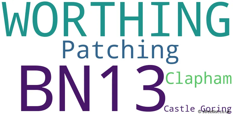
The largest settlement in the BN13 postal code is WORTHING followed by Patching, and Clapham.
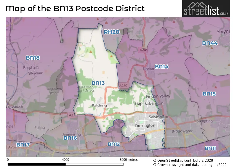
The BN13 Postcode shares a border with BN14 (WORTHING, Findon, Tarring), BN18 (Yapton, ARUNDEL, Walberton), RH20 (Storrington, PULBOROUGH, West Chiltington), BN16 (Rustington, East Preston, Angmering), BN12 (Goring-by-Sea, Ferring) and BN11 (WORTHING).
The primary settlement in the BN13 postcode district is Worthing, located in the county of West Sussex, England. Other significant settlements in this postcode district include Castle Goring, Clapham, and Patching.
For the district BN13, we have data on 3 postcode sectors. Here's a breakdown: The sector BN13 1, covers Worthing in West Sussex. The sector BN13 2, covers Worthing in West Sussex. The sector BN13 3, covers Worthing in West Sussex.

Map of the BN13 Postcode District
Explore the BN13 postcode district by using our free interactive map.
When it comes to local government, postal geography often disregards political borders. However, for a breakdown in the BN13 District: the district mostly encompasses the Worthing District (B) (739 postcodes), and finally, the Arun District area (33 postcodes).
Weather Forecast for BN13
Press Button to Show Forecast for Chanctonbury Hill
| Time Period | Icon | Description | Temperature | Rain Probability | Wind |
|---|---|---|---|---|---|
| 06:00 to 09:00 | Drizzle | 6.0°C (feels like 1.0°C) | 48.00% | ENE 16 mph | |
| 09:00 to 12:00 | Mist | 8.0°C (feels like 5.0°C) | 53.00% | ENE 11 mph | |
| 12:00 to 15:00 | Cloudy | 11.0°C (feels like 8.0°C) | 34.00% | ESE 11 mph | |
| 15:00 to 18:00 | Cloudy | 10.0°C (feels like 8.0°C) | 15.00% | E 9 mph | |
| 18:00 to 21:00 | Heavy rain | 9.0°C (feels like 6.0°C) | 89.00% | NE 18 mph | |
| 21:00 to 00:00 | Heavy rain | 8.0°C (feels like 4.0°C) | 91.00% | NE 20 mph |
Press Button to Show Forecast for Chanctonbury Hill
| Time Period | Icon | Description | Temperature | Rain Probability | Wind |
|---|---|---|---|---|---|
| 00:00 to 03:00 | Heavy rain | 8.0°C (feels like 4.0°C) | 91.00% | NE 16 mph | |
| 03:00 to 06:00 | Heavy rain | 8.0°C (feels like 4.0°C) | 93.00% | E 16 mph | |
| 06:00 to 09:00 | Heavy rain | 8.0°C (feels like 5.0°C) | 81.00% | WSW 11 mph | |
| 09:00 to 12:00 | Heavy rain | 7.0°C (feels like 3.0°C) | 83.00% | W 16 mph | |
| 12:00 to 15:00 | Overcast | 8.0°C (feels like 4.0°C) | 24.00% | W 18 mph | |
| 15:00 to 18:00 | Cloudy | 9.0°C (feels like 6.0°C) | 12.00% | W 13 mph | |
| 18:00 to 21:00 | Cloudy | 9.0°C (feels like 6.0°C) | 9.00% | WSW 13 mph | |
| 21:00 to 00:00 | Partly cloudy (night) | 7.0°C (feels like 4.0°C) | 4.00% | SW 13 mph |
Press Button to Show Forecast for Chanctonbury Hill
| Time Period | Icon | Description | Temperature | Rain Probability | Wind |
|---|---|---|---|---|---|
| 00:00 to 03:00 | Partly cloudy (night) | 6.0°C (feels like 3.0°C) | 5.00% | SW 9 mph | |
| 03:00 to 06:00 | Partly cloudy (night) | 5.0°C (feels like 2.0°C) | 2.00% | SW 9 mph | |
| 06:00 to 09:00 | Partly cloudy (day) | 7.0°C (feels like 4.0°C) | 1.00% | S 9 mph | |
| 09:00 to 12:00 | Partly cloudy (day) | 10.0°C (feels like 7.0°C) | 1.00% | S 11 mph | |
| 12:00 to 15:00 | Partly cloudy (day) | 11.0°C (feels like 8.0°C) | 2.00% | S 13 mph | |
| 15:00 to 18:00 | Sunny day | 11.0°C (feels like 9.0°C) | 2.00% | S 11 mph | |
| 18:00 to 21:00 | Sunny day | 11.0°C (feels like 9.0°C) | 1.00% | SSE 9 mph | |
| 21:00 to 00:00 | Clear night | 8.0°C (feels like 5.0°C) | 1.00% | SE 11 mph |
Press Button to Show Forecast for Chanctonbury Hill
| Time Period | Icon | Description | Temperature | Rain Probability | Wind |
|---|---|---|---|---|---|
| 00:00 to 03:00 | Clear night | 8.0°C (feels like 5.0°C) | 2.00% | ESE 13 mph | |
| 03:00 to 06:00 | Clear night | 7.0°C (feels like 4.0°C) | 3.00% | ESE 13 mph | |
| 06:00 to 09:00 | Sunny day | 8.0°C (feels like 5.0°C) | 3.00% | ESE 13 mph | |
| 09:00 to 12:00 | Partly cloudy (day) | 11.0°C (feels like 9.0°C) | 4.00% | SE 11 mph | |
| 12:00 to 15:00 | Partly cloudy (day) | 13.0°C (feels like 11.0°C) | 6.00% | SE 13 mph | |
| 15:00 to 18:00 | Partly cloudy (day) | 14.0°C (feels like 11.0°C) | 6.00% | SE 11 mph | |
| 18:00 to 21:00 | Cloudy | 12.0°C (feels like 10.0°C) | 10.00% | SE 11 mph | |
| 21:00 to 00:00 | Partly cloudy (night) | 10.0°C (feels like 7.0°C) | 8.00% | ESE 11 mph |
Where is the BN13 Postcode District?
The BN13 postcode district is located in Worthing, a town in West Sussex. Worthing is surrounded by several nearby towns, including Lancing (5.76 miles to the East), Arundel (5.77 miles to the West), Steyning (6.06 miles to the North East), Littlehampton (6.81 miles to the South West), and Pulborough (8.10 miles to the North). Additionally, the centre of London is approximately 47.20 miles from this postcode district.
The district is within the post town of WORTHING.
The sector has postcodes within the nation of England.
The BN13 Postcode District is in the West Sussex (South West) region of Surrey, East and West Sussex within the South East (England).
| Postcode Sector | Delivery Office |
|---|---|
| BN13 1 | Worthing Delivery Office |
| BN13 2 | Worthing Delivery Office |
| BN13 3 | Worthing Delivery Office |
| B | N | 1 | 3 | - | X | X | X |
| B | N | 1 | 3 | Space | Numeric | Letter | Letter |
Current Monthly Rental Prices
| # Bedrooms | Min Price | Max Price | Avg Price |
|---|---|---|---|
| 2 | £895 | £1,500 | £1,264 |
| 3 | £1,450 | £1,450 | £1,450 |
| 4 | £2,000 | £2,750 | £2,375 |
Current House Prices
| # Bedrooms | Min Price | Max Price | Avg Price |
|---|---|---|---|
| £825,000 | £825,000 | £825,000 | |
| 3 | £750,000 | £850,000 | £813,333 |
| 4 | £735,000 | £1,295,000 | £906,786 |
| 5 | £825,000 | £5,750,000 | £1,725,000 |
| 12 | £825,000 | £825,000 | £825,000 |
Estate Agents who Operate in the BN13 District
| Logo | Name | Brand Name | Address | Contact Number | Total Properties |
|---|---|---|---|---|---|
 | Findon Valley | Jacobs Steel | 228 Findon Road, Worthing, BN14 0EJ | 01903 257148 | 23 |
 | Worthing | Robert Luff & Co | 30 Guildbourne Centre, Worthing, West Sussex, BN11 1LZ | 01903 257113 | 16 |
 | Broadwater | Bacon & Company | 14-16 Broadwater Street West, Worthing, BN14 9DA | 01903 524000 | 15 |
 | Goring By Sea | Bacon & Company | 72 Goring Road Goring-By-Sea Worthing BN12 4AB | 01903 520002 | 14 |
 | Worthing | James & James Estate Agents | 119 George V Avenue, Goring-By-Sea, Worthing, BN11 5SA | 01903 958770 | 13 |
| Type of Property | 2018 Average | 2018 Sales | 2017 Average | 2017 Sales | 2016 Average | 2016 Sales | 2015 Average | 2015 Sales |
|---|---|---|---|---|---|---|---|---|
| Detached | £399,367 | 235 | £395,040 | 134 | £392,811 | 160 | £361,649 | 150 |
| Semi-Detached | £314,079 | 224 | £313,899 | 242 | £297,628 | 214 | £273,562 | 195 |
| Terraced | £278,052 | 129 | £279,639 | 147 | £275,564 | 172 | £244,853 | 177 |
| Flats | £192,732 | 77 | £189,759 | 129 | £185,471 | 107 | £163,421 | 102 |