The BS23 2 postcode sector is within the county of Somerset.
Did you know? According to the 2021 Census, the BS23 2 postcode sector is home to a bustling 9,582 residents!
Given that each sector allows for 400 unique postcode combinations. Letters C, I, K, M, O and V are not allowed in the last two letters of a postcode. With 261 postcodes already in use, this leaves 139 units available.
The BS23 2 postal code covers the settlement of WESTON-SUPER-MARE.
The BS23 2 Postcode shares a border with BS22 9 (WESTON-SUPER-MARE, Kewstoke, Worle), BS23 3 (WESTON-SUPER-MARE), BS22 8 (WESTON-SUPER-MARE, Milton) and BS23 1 (WESTON-SUPER-MARE).
The sector is within the post town of WESTON-SUPER-MARE.
BS23 2 is a postcode sector within the BS23 postcode district which is within the BS Bristol postcode area.
The Royal Mail delivery office for the BS23 2 postal sector is the Weston Super Mare Delivery Office.
The area of the BS23 2 postcode sector is 1.10 square miles which is 2.84 square kilometres or 702.01 square acres.

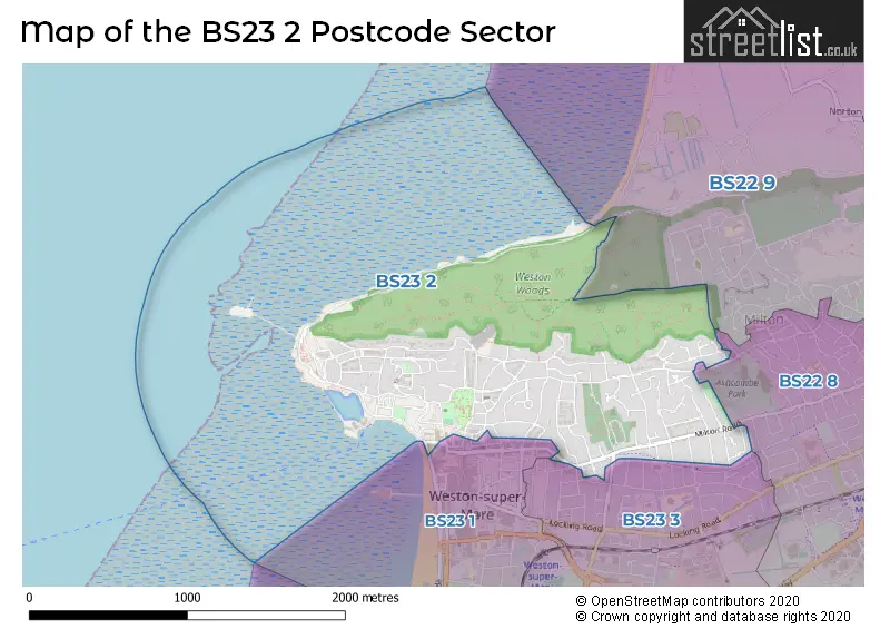
Map of the BS23 2 Postcode Sector
Explore the BS23 2 postcode sector by using our free interactive map.
| B | S | 2 | 3 | - | 2 | X | X |
| B | S | 2 | 3 | Space | 2 | Letter | Letter |
Official List of Streets
WESTON-SUPER-MARE (104 Streets)
Unofficial Streets or Alternative Spellings
WESTON-SUPER-MARE
ASHCOMBE ROAD BAKER STREET CLIFF ROAD HIGH STREET LONGTON GROVE ROAD OAKFORD AVENUE ROYAL PARADE STAFFORD ROAD UPPER BRISTOL ROAD WADHAM STREET WOOLER ROAD WORLEBURY HILL ROAD WORLEBURY PARK ROAD BIRKETT ROAD BRISTOL ROAD-LOWER CHRIST CHURCH PATH COLONEL STEPHENS WAY GROVE LANE MARKET LANE MONTEPELIER MONTPELIER PATH SAINT JOHNS CLOSE SAINT PETERS AVENUE SOUTH CRESCENT TIVOLI LANE TREWARTHA ROAD VICTORIA PLACEKewstoke
KEWSTOKE ROADSchools and Places of Education Within the BS23 2 Postcode Sector
Weston College
Further education
Knightstone Road, Weston-Super-Mare, Somerset, BS23 2AL
Head: Dr Paul Phillips
Ofsted Rating: Good
Inspection: 2023-12-08 (179 days ago)
Website: Visit Weston College Website
Phone: 01934411411
Number of Pupils: 0
House Prices in the BS23 2 Postcode Sector
| Type of Property | 2018 Average | 2018 Sales | 2017 Average | 2017 Sales | 2016 Average | 2016 Sales | 2015 Average | 2015 Sales |
|---|---|---|---|---|---|---|---|---|
| Detached | £337,915 | 33 | £345,804 | 28 | £294,050 | 34 | £340,145 | 37 |
| Semi-Detached | £290,581 | 24 | £277,673 | 30 | £263,009 | 39 | £267,339 | 22 |
| Terraced | £205,538 | 13 | £214,130 | 15 | £202,000 | 11 | £190,581 | 16 |
| Flats | £144,147 | 165 | £147,921 | 237 | £130,394 | 187 | £126,754 | 189 |
Important Postcodes BS23 2 in the Postcode Sector
BS23 2AG is the postcode for LAW AND PROFESSIONAL SERVICES ACADEMY, Weston College, 10-16 Lower Church Road
BS23 2AJ is the postcode for H M Revenue & Customs, Grove Road
BS23 2AL is the postcode for THE WORKSHOP, Weston College, Knightstone Road, THE CONFERENCE CENTRE, Weston College, Knightstone Road, Weston College, Knightstone Campus,, Knightstone Rd,, and Weston College, Knightstone Road
BS23 2AN is the postcode for Lauriston Hotel, 6-12 Knightstone Road
BS23 2NH is the postcode for Twynham Primary School, Marsh Lane, Fairmile
BS23 2QZ is the postcode for Stafford Place Surgery, 4 Stafford Place
| The BS23 2 Sector is within these Local Authorities |
|
|---|---|
| The BS23 2 Sector is within these Counties |
|
| The BS23 2 Sector is within these Water Company Areas |
|