The CF14 1 postcode sector is within the county of South Glamorgan.
Did you know? According to the 2021 Census, the CF14 1 postcode sector is home to a bustling 9,370 residents!
Given that each sector allows for 400 unique postcode combinations. Letters C, I, K, M, O and V are not allowed in the last two letters of a postcode. With 236 postcodes already in use, this leaves 164 units available.
The largest settlement in the CF14 1 postal code is WHITCHURCH followed by CARDIFF, and HEATH.
The CF14 1 Postcode shares a border with CF14 2 (LLANDAFF NORTH, WHITCHURCH, CARDIFF), CF14 3 (GABALFA, CARDIFF, HEATH), CF14 4 (HEATH, CARDIFF, RHIWBINA), CF14 6 (RHIWBINA, WHITCHURCH, CARDIFF) and CF14 7 (WHITCHURCH, RHIWBINA, CARDIFF).
The sector is within the post town of CARDIFF.
CF14 1 is a postcode sector within the CF14 postcode district which is within the CF Cardiff postcode area.
The Royal Mail delivery office for the CF14 1 postal sector is the Cardiff North Delivery Office.
The area of the CF14 1 postcode sector is 0.75 square miles which is 1.94 square kilometres or 480.39 square acres.

Map of the CF14 1 Postcode Sector
Explore the CF14 1 postcode sector by using our free interactive map.
| C | F | 1 | 4 | - | 1 | X | X |
| C | F | 1 | 4 | Space | 1 | Letter | Letter |
Official List of Streets
Whitchurch (17 Streets)
CARDIFF (92 Streets)
Unofficial Streets or Alternative Spellings
Gabalfa
NORTH ROADCARDIFF
CORONATION ROAD FORELAND ROAD GLAN-Y-NANT ROAD GLAN-Y-NANT TERRACE GROVE PLACE GROVELAND ROAD HEOL DON HEOL-Y-FORLAN LON-Y-GROES LON-Y-PARC PENLLINE ROAD RICHS ROADWhitchurch
CHURCH ROAD BISHOPS COURT CAE GWYN ROAD CARADOC ROAD HEOL GATTWG HEOL PENYFAI HEOL-Y-WAUN LIMEBOURNE COURT LLWYNDERW ROAD NORTHERN AVENUE PANT-BACH ROAD PLAS NEWYDD RIALTO COURT ST MARGARETS ROAD T? NANT T? NEWYDD T?N Y PWLL ROAD TWYN-Y-FEDWEN TY-WERN ROAD TYN-Y-PWLL ROADLlandaff North
COLLEGE ROAD STATION ROAD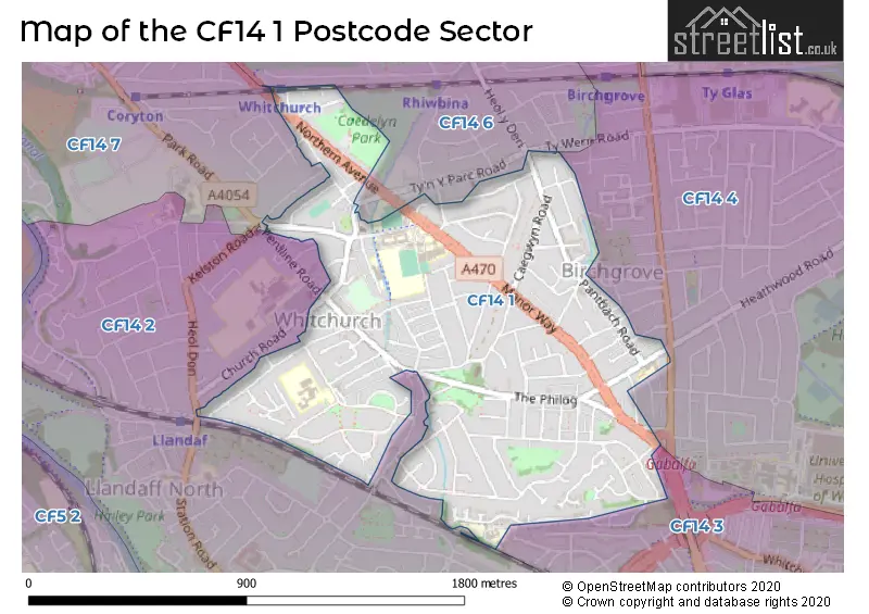
House Prices in the CF14 1 Postcode Sector
| Type of Property | 2018 Average | 2018 Sales | 2017 Average | 2017 Sales | 2016 Average | 2016 Sales | 2015 Average | 2015 Sales |
|---|---|---|---|---|---|---|---|---|
| Detached | £341,713 | 43 | £330,414 | 28 | £358,934 | 38 | £329,871 | 21 |
| Semi-Detached | £313,310 | 62 | £313,491 | 63 | £277,394 | 71 | £266,477 | 60 |
| Terraced | £258,111 | 27 | £227,243 | 47 | £227,061 | 37 | £208,559 | 37 |
| Flats | £144,180 | 25 | £136,953 | 37 | £122,885 | 48 | £127,927 | 24 |
Important Postcodes CF14 1 in the Postcode Sector
CF14 1AP is the postcode for Eglwys Newydd Primary School, Glan-y-Nant Road, and Ysgol Melin Gruffydd, Glan-y-Nant Road
CF14 1NL is the postcode for FOUNDATION PHASE, Whitchurch Primary School, Erw Las, Whitchurch Primary School, Erw Las, and MAIN BUILDING, Whitchurch Primary School, Erw Las
CF14 1RR is the postcode for Birchgrove Primary School, Birchgrove Road
CF14 1WL is the postcode for LIBRARY BLOCK (BLOCKS 4,13 AND 15), Whitchurch Lower High School, Glan-y-Nant Terrace, QUAD BLOCK (BLOCKS 1,2,3,5,11,12 AND 16), Whitchurch Lower High School, Glan-y-Nant Terrace, TECHNOLOGY, SCIENCE AND POOL BLOCK (BLOCKS 6,7,8,9 AND 19), Whitchurch Lower High School, Glan-y-Nant Terrace, Whitchurch Lower High School, Glan-y-Nant Terrace, GYM, SEN AND TECH BLOCK (BLOCKS 5,11 AND 12), Whitchurch Lower High School, Glan-y-Nant Terrace, QUAD BLOCK (BLOCK 1), Whitchurch Lower High School, Glan-y-Nant Terrace, and MUSIC (BLOCK 19), Whitchurch Lower High School, Glan-y-Nant Terrace
| The CF14 1 Sector is within these Local Authorities |
|
|---|---|
| The CF14 1 Sector is within these Counties |
|
| The CF14 1 Sector is within these Water Company Areas |
|