The CF14 6 postcode sector is within the county of South Glamorgan.
Did you know? According to the 2021 Census, the CF14 6 postcode sector is home to a bustling 9,448 residents!
Given that each sector allows for 400 unique postcode combinations. Letters C, I, K, M, O and V are not allowed in the last two letters of a postcode. With 219 postcodes already in use, this leaves 181 units available.
The largest settlement in the CF14 6 postal code is RHIWBINA followed by WHITCHURCH, and CARDIFF.
The CF14 6 Postcode shares a border with CF15 7 (TONGWYNLAIS, TAFF'S WELL, Taffs Well), CF83 1 (CAERPHILLY, LANSBURY PARK, WATFORD), CF14 1 (WHITCHURCH, CARDIFF, HEATH), CF14 4 (HEATH, CARDIFF, RHIWBINA), CF14 5 (LLANISHEN, CARDIFF), CF14 7 (WHITCHURCH, RHIWBINA, CARDIFF) and CF14 9 (THORNHILL, CARDIFF, RHIWBINA).
The sector is within the post town of CARDIFF.
CF14 6 is a postcode sector within the CF14 postcode district which is within the CF Cardiff postcode area.
The Royal Mail delivery office for the CF14 6 postal sector is the Cardiff North Delivery Office.
The area of the CF14 6 postcode sector is 1.85 square miles which is 4.79 square kilometres or 1,183.74 square acres.

Map of the CF14 6 Postcode Sector
Explore the CF14 6 postcode sector by using our free interactive map.
| C | F | 1 | 4 | - | 6 | X | X |
| C | F | 1 | 4 | Space | 6 | Letter | Letter |
Official List of Streets
CARDIFF (77 Streets)
Rhiwbina (11 Streets)
Unofficial Streets or Alternative Spellings
CARDIFF
CAER WENALLT CLAS TYN-Y-CAE HEOL-Y-FORLAN KYLE AVENUE LON TYN-Y-CAE LON-Y-DAIL LON-Y-DDERWEN LON-Y-DERI LON-Y-MYNYDD LON-Y-PARC LON-Y-RHYD LON-Y-WINCI LON-YSGUBOR L�N GANOL MAES-Y-DERI MAES-Y-FELIN MANOR WAY MAVIS GROVE MIN-Y-NANT OLD CHURCH ROAD PEN-Y-GROES ROAD WAUN-Y-GROES AVENUE CLAS T?N Y CAE CLOS Y CRAIG CLOS YR AER CLOS YR HAFOD CLOS YR WENALLT CLOS-MABON CLOS-YR-ARDD COED YR YNN GLANRHYD HEOL T?N Y CAE HEOL TYN-Y-CAE HEOL-Y-BONT HEOL-Y-BRYN HEOL-Y-COED HEOL-Y-DERI HEOL-Y-FELIN HEOL-Y-NANT LEE COURT LON YSGYBOR LONCAE PORTH L�N T?N Y CAE MAES Y PARC NANT WALLA NORTHERN AVENUE PANT-BACH ROAD T?N Y CAE GROVE TROED Y RHIW TY-WERN AVENUE TY-WERN ROAD TYN-Y-CAE GROVE TYN-Y-PARC ROADRhiwbina
BLAEN-Y-COED PEN-Y-DRE TY-GWYN ROADLlanishen
CILGERRAN CRESCENTThornhill
WENALLT ROADWhitchurch
ASH GROVE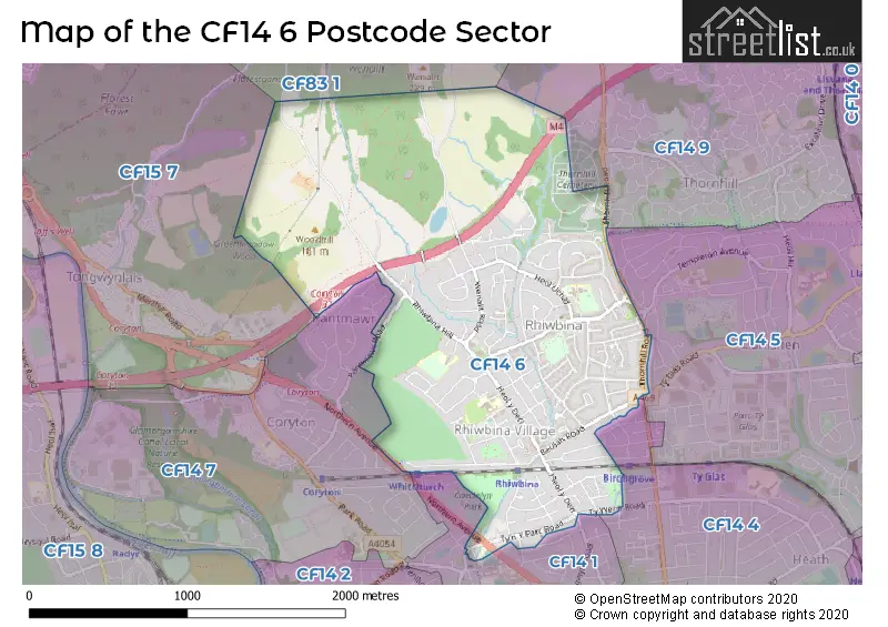
House Prices in the CF14 6 Postcode Sector
| Type of Property | 2018 Average | 2018 Sales | 2017 Average | 2017 Sales | 2016 Average | 2016 Sales | 2015 Average | 2015 Sales |
|---|---|---|---|---|---|---|---|---|
| Detached | £424,143 | 49 | £415,416 | 47 | £389,056 | 35 | £348,330 | 47 |
| Semi-Detached | £313,279 | 87 | £304,073 | 99 | £296,818 | 90 | £274,862 | 76 |
| Terraced | £323,111 | 18 | £242,048 | 21 | £253,767 | 15 | £238,974 | 21 |
| Flats | £136,013 | 37 | £139,218 | 41 | £130,910 | 42 | £123,629 | 35 |
Important Postcodes CF14 6 in the Postcode Sector
CF14 6EH is the postcode for City of Cardiff Council, Rhiwbina Library, Pen-y-Dre
CF14 6HL is the postcode for Rhiwbina Junior & Infant School, Lon Ucha, and Rhiwbina Primary School, Lon Ucha, Rhiwbina
CF14 6JT is the postcode for Rhiwbina Clinic, Groes Lon
CF14 6SS is the postcode for BLOCK 2, Llanishen Fach Primary School, Heol Uchaf, BLOCK 1, Llanishen Fach Primary School, Heol Uchaf, Llanishen Fach Primary School, Heol Uchaf, and Llanishen Fach Primary School, Heol Uchaf, Rhiwbina
CF14 6UJ is the postcode for Greenhill Special School, Heol Brynglas
| The CF14 6 Sector is within these Local Authorities |
|
|---|---|
| The CF14 6 Sector is within these Counties |
|
| The CF14 6 Sector is within these Water Company Areas |
|