The CH44 postcode district is a postal district located in the CH Chester postcode area with a population of 29,347 residents according to the 2021 England and Wales Census.
The area of the CH44 postcode district is 2.00 square miles which is 5.18 square kilometres or 1,280.81 acres.
Currently, the CH44 district has about 768 postcode units spread across 10 geographic postcode sectors.
Given that each sector allows for 400 unique postcode combinations, the district has a capacity of 4,000 postcodes. With 768 postcodes already in use, this leaves 3232 units available.
The CH44 postal code covers the settlement of WALLASEY.
The postcode area has a boundary with Mersey.
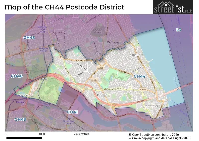
The CH44 Postcode shares a border with CH41 (BIRKENHEAD), CH46 (WIRRAL, Moreton) and CH45 (WALLASEY).
In the CH44 postcode district in Merseyside, the primary settlement is Wallasey. The most significant post town in this district is also Wallasey. Other significant settlements within this district include Wallasey.
For the district CH44, we have data on 10 postcode sectors. Here's a breakdown: The sector CH44 0, covers Wallasey in Merseyside. The sector CH44 1, covers Wallasey in Merseyside. The sector CH44 2, covers Wallasey in Merseyside. The sector CH44 3, covers Wallasey in Merseyside. The sector CH44 4, covers Wallasey in Merseyside. The sector CH44 5, covers Wallasey in Merseyside. The sector CH44 6, covers Wallasey in Merseyside. The sector CH44 7, covers Wallasey in Merseyside. The sector CH44 8, covers Wallasey in Merseyside. The sector CH44 9, covers Wallasey in Merseyside.

Map of the CH44 Postcode District
Explore the CH44 postcode district by using our free interactive map.
When it comes to local government, postal geography often disregards political borders. However, for a breakdown in the CH44 District: the district mostly encompasses the Wirral District (B) area with a total of 773 postcodes.
Weather Forecast for CH44
Press Button to Show Forecast for Liverpool
| Time Period | Icon | Description | Temperature | Rain Probability | Wind |
|---|---|---|---|---|---|
| 09:00 to 12:00 | Partly cloudy (day) | 7.0°C (feels like 6.0°C) | 1.00% | E 4 mph | |
| 12:00 to 15:00 | Cloudy | 9.0°C (feels like 8.0°C) | 6.00% | NNE 4 mph | |
| 15:00 to 18:00 | Cloudy | 10.0°C (feels like 8.0°C) | 6.00% | N 7 mph | |
| 18:00 to 21:00 | Cloudy | 9.0°C (feels like 8.0°C) | 6.00% | NNE 7 mph | |
| 21:00 to 00:00 | Cloudy | 7.0°C (feels like 5.0°C) | 8.00% | NE 9 mph |
Press Button to Show Forecast for Liverpool
| Time Period | Icon | Description | Temperature | Rain Probability | Wind |
|---|---|---|---|---|---|
| 00:00 to 03:00 | Partly cloudy (night) | 6.0°C (feels like 3.0°C) | 6.00% | ESE 9 mph | |
| 03:00 to 06:00 | Partly cloudy (night) | 4.0°C (feels like 2.0°C) | 6.00% | ESE 7 mph | |
| 06:00 to 09:00 | Partly cloudy (day) | 5.0°C (feels like 2.0°C) | 5.00% | E 7 mph | |
| 09:00 to 12:00 | Cloudy | 8.0°C (feels like 6.0°C) | 8.00% | ESE 7 mph | |
| 12:00 to 15:00 | Overcast | 10.0°C (feels like 9.0°C) | 14.00% | E 7 mph | |
| 15:00 to 18:00 | Cloudy | 11.0°C (feels like 9.0°C) | 18.00% | NE 7 mph | |
| 18:00 to 21:00 | Cloudy | 10.0°C (feels like 8.0°C) | 15.00% | ENE 9 mph | |
| 21:00 to 00:00 | Partly cloudy (night) | 9.0°C (feels like 6.0°C) | 13.00% | NE 9 mph |
Press Button to Show Forecast for Liverpool
| Time Period | Icon | Description | Temperature | Rain Probability | Wind |
|---|---|---|---|---|---|
| 00:00 to 03:00 | Cloudy | 7.0°C (feels like 4.0°C) | 17.00% | NE 9 mph | |
| 03:00 to 06:00 | Cloudy | 6.0°C (feels like 3.0°C) | 16.00% | NNE 11 mph | |
| 06:00 to 09:00 | Light rain | 7.0°C (feels like 4.0°C) | 47.00% | NNE 11 mph | |
| 09:00 to 12:00 | Light rain | 8.0°C (feels like 5.0°C) | 49.00% | NNE 11 mph | |
| 12:00 to 15:00 | Light rain | 9.0°C (feels like 6.0°C) | 52.00% | NNE 11 mph | |
| 15:00 to 18:00 | Light rain | 10.0°C (feels like 7.0°C) | 52.00% | N 11 mph | |
| 18:00 to 21:00 | Partly cloudy (day) | 10.0°C (feels like 8.0°C) | 13.00% | WNW 13 mph | |
| 21:00 to 00:00 | Clear night | 9.0°C (feels like 7.0°C) | 11.00% | WNW 11 mph |
Where is the CH44 Postcode District?
The data indicates that the CH44 postcode district is located in Wallasey, a town in the United Kingdom. Wallasey is situated near several other towns, including Prenton in the south (about 2.09 miles away), Bootle in the northeast (about 4.38 miles away), Prescot in the east (about 10.32 miles away), Ellesmere Port in the southeast (about 10.88 miles away), and Bagillt in the southwest (about 11.88 miles away). Additionally, the CH44 district is approximately 180.34 miles away from the center of London.
The district is within the post town of WALLASEY.
The sector has postcodes within the nation of England.
The CH44 Postcode District is in the Wirral region of Merseyside within the North West (England).
Postcode Sectors within the CH44 District
| Postcode Sector | Delivery Office |
|---|---|
| CH44 0 | Wallasey Delivery Office |
| CH44 1 | Wallasey Delivery Office |
| CH44 2 | Wallasey Delivery Office |
| CH44 3 | Wallasey Delivery Office |
| CH44 4 | Wallasey Delivery Office |
| CH44 5 | Wallasey Delivery Office |
| CH44 6 | Wallasey Delivery Office |
| CH44 7 | Wallasey Delivery Office |
| CH44 8 | Wallasey Delivery Office |
| CH44 9 | Wallasey Delivery Office |
| C | H | 4 | 4 | - | X | X | X |
| C | H | 4 | 4 | Space | Numeric | Letter | Letter |
Current Monthly Rental Prices
| # Bedrooms | Min Price | Max Price | Avg Price |
|---|---|---|---|
| £500 | £575 | £538 | |
| 1 | £477 | £795 | £617 |
| 2 | £525 | £850 | £627 |
| 3 | £725 | £795 | £760 |
| 4 | £900 | £900 | £900 |
| 6 | £575 | £575 | £575 |
Current House Prices
| # Bedrooms | Min Price | Max Price | Avg Price |
|---|---|---|---|
| 2 | £290,000 | £290,000 | £290,000 |
| 3 | £250,000 | £400,000 | £308,545 |
| 4 | £254,750 | £385,000 | £304,306 |
| 5 | £260,000 | £285,000 | £275,000 |
| 6 | £290,000 | £290,000 | £290,000 |
Estate Agents who Operate in the CH44 District
| Logo | Name | Brand Name | Address | Contact Number | Total Properties |
|---|---|---|---|---|---|
 | Wallasey | Karl Tatler Estate Agents | 117-119 Wallasey Road, Wallasey, CH44 2AA | 0151 668 0000 | 41 |
 | Wallasey | Jones & Chapman | 108 Wallasey Road, Wallasey, CH44 2AE | 0151 453 7997 | 28 |
 | Wallasey | Bakewell and Horner | 93/95 Wallasey Road Wallasey Cheshire, CH44 2AQ | 0151 453 2668 | 23 |
 | Wallasey | Harper & Woods | 100 Wallasey Road, Wallasey, Wirral, Merseyside, CH44 2AE | 0151 453 1124 | 22 |
 | Wallasey | Hunters | 51-53 Wallasey Road, Wallasey, CH45 4NN | 0151 453 4546 | 19 |
| Type of Property | 2018 Average | 2018 Sales | 2017 Average | 2017 Sales | 2016 Average | 2016 Sales | 2015 Average | 2015 Sales |
|---|---|---|---|---|---|---|---|---|
| Detached | £205,069 | 13 | £170,233 | 15 | £146,167 | 9 | £154,116 | 21 |
| Semi-Detached | £136,326 | 126 | £131,104 | 124 | £128,079 | 126 | £119,606 | 144 |
| Terraced | £89,072 | 264 | £84,708 | 274 | £79,474 | 222 | £75,927 | 222 |
| Flats | £95,733 | 38 | £90,424 | 21 | £70,548 | 30 | £71,144 | 17 |