The CH62 2 postcode sector is within the county of Merseyside.
Did you know? According to the 2021 Census, the CH62 2 postcode sector is home to a bustling 3,104 residents!
Given that each sector allows for 400 unique postcode combinations. Letters C, I, K, M, O and V are not allowed in the last two letters of a postcode. With 79 postcodes already in use, this leaves 321 units available.
The largest settlements in the CH62 2 postal code are WIRRAL and Bromborough.
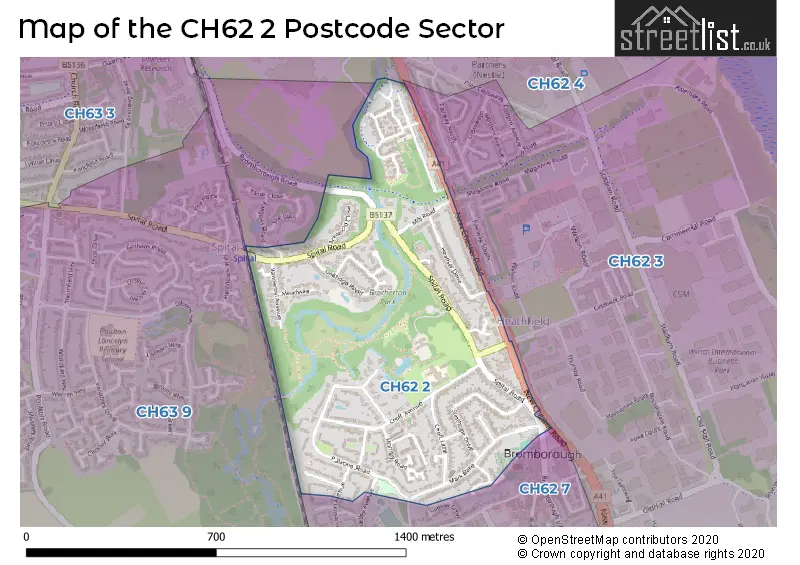
The CH62 2 Postcode shares a border with CH62 4 (WIRRAL, Bromborough Pool, Port Sunlight), CH62 3 (WIRRAL, Bromborough, Old Hall Industrial Estate), CH62 7 (WIRRAL, Bromborough) and CH63 9 (WIRRAL, Bebington).
The sector is within the post town of WIRRAL.
CH62 2 is a postcode sector within the CH6 postcode district which is within the CH Chester postcode area.
The Royal Mail delivery office for the CH62 2 postal sector is the unknown.
The area of the CH62 2 postcode sector is 0.39 square miles which is 1.01 square kilometres or 250.39 square acres.
Waterways within the CH62 2 postcode sector include the Dibbinsdale brook.

Map of the CH62 2 Postcode Sector
Explore the CH62 2 postcode sector by using our free interactive map.
| C | H | 6 | 2 | - | 2 | X | X |
| C | H | 6 | 2 | Space | 2 | Letter | Letter |
Official List of Streets
WIRRAL (30 Streets)
Bromborough (8 Streets)
Unofficial Streets or Alternative Spellings
Schools and Places of Education Within the CH62 2 Postcode Sector
Co-op Academy Woodslee
Academy sponsor led
Croft Avenue, Wirral, Merseyside, CH62 2BP
Head: Ms Katy Bergman
Ofsted Rating: Good
Inspection: 2023-11-16 (196 days ago)
Website: Visit Co-op Academy Woodslee Website
Phone: 01513341406
Number of Pupils: 222
House Prices in the CH62 2 Postcode Sector
| Type of Property | 2018 Average | 2018 Sales | 2017 Average | 2017 Sales | 2016 Average | 2016 Sales | 2015 Average | 2015 Sales |
|---|---|---|---|---|---|---|---|---|
| Detached | £250,054 | 9 | £281,437 | 8 | £284,000 | 11 | £276,630 | 15 |
| Semi-Detached | £204,651 | 35 | £186,414 | 18 | £183,457 | 23 | £176,795 | 20 |
| Terraced | £174,670 | 10 | £130,806 | 13 | £152,054 | 12 | £142,173 | 11 |
| Flats | £132,000 | 6 | £73,830 | 10 | £96,071 | 7 | £81,196 | 14 |
Important Postcodes CH62 2 in the Postcode Sector
CH62 2AA is the postcode for Royal Mail, New Ferry & Eastham Delivery Office, 1 Marquis Street
CH62 2BP is the postcode for Woodslee Primary School, Croft Avenue, and Wirral Borough Council, Woodslee Primary School, Croft Avenue
CH62 2DE is the postcode for Meadowcroft, 304 Spital Road
| The CH62 2 Sector is within these Local Authorities |
|
|---|---|
| The CH62 2 Sector is within these Counties |
|
| The CH62 2 Sector is within these Water Company Areas |
|