CT6 7UW is a postal code used within the United Kingdom for delivering mail.
Postcodes are made up of two parts. The part before the space (CT6) is called the outward code. The part after the space (7UW) is called the inward code. The letters C, I, K, M, O and V are not allowed in the inward code. In addition to the inward and outward code, the postcode can be broken up into four parts:
- Postal Area. In our case CT which means Canterbury.
- Postal District. In our case CT6.
- Postal Sector. In our case CT6 7.
- Postcode Unit. The last two letters. In our case UW.
The regional mail center for the post area CT is the Princess Royal Distribution Centre, which is located at Blackmore Drive, North Circular, LONDON , NW10 7RH.
The final port of call for any post addressed to the CT6 7UW postcode is the local delivery office (DO) which is . Here the post will be sorted ready for delivery.
The properties in the CT6 7UW postcode have the street address of Arden Road
Did you know? According to the 2021 Census, the CT6 7UW postcode is home to a bustling 39 residents!
It is situated within the post town of HERNE BAY within the old postal county of Kent.
CT6 7UW is within the village of Hunters Forstal.
The CT6 7UW postcode area is composed of 100% residential properties, 0% commercial properties, and 0% public properties.
According to our data. Most dwellings in CT6 7UW are houses. Of these houses, most are detached.
Most properties in CT6 7UW are owned by the occupiers with the rest being unknown tenure.

Interactive Mapping Showing UPRNs within the CT6 7UW Postcode Boundaries
Use the search box to search for other postcodes or places.
| Property Type | Percentage |
|---|---|
| Residential | 100% |
| Commercial | 0% |
| Public | 0% |
Map Coordinates for CT6 7UW
| Latitude | 51.3558299139 |
|---|---|
| Longitude | 1.14397992105 |

What are the Broadband Speeds like in the CT6 7UW Postcode?
Download Speeds For CT6 7UW

| Average Mbps | 53.100 |
|---|---|
| Median Mbps | 74.100 |
| Maximum Mbps | 79.980 |
CT6 7UW has an average download speed of 53.1 Megabits per second (Mbps).
1,460 other postcode units have the same broadband speed.
30% of postcodes (357,181) have slower broadband speeds.
70% of postcodes (826,000) have faster broadband speeds.
Upload Speeds For CT6 7UW

| Average Mbps | 13.400 |
|---|---|
| Median Mbps | 19.500 |
| Maximum Mbps | 20.000 |
CT6 7UW has an average upload speed of 13.4 Megabits per second (Mbps).
11,686 other postcode units have the same upload speed.
49% of postcodes (580,017) have slower upload speeds.
50% of postcodes (592,938) have faster upload speeds.
Schools within a five minute drive of CT6 7UW Postcode
England Primary Schools
Reculver Church of England Primary School
Address: Reculver Church of England Primary School, Hillborough, Herne Bay, Kent, CT6 6TA
Distance: 1.58 miles
Contact: 01227375907
Hoath Primary School
Address: Hoath Primary School, School Lane, Hoath, Canterbury, Kent, CT3 4LA
Distance: 1.69 miles
Contact: 01227860249
Herne Church of England Infant and Nursery School
Address: Herne Church of England Infant and Nursery School, Palmer Close, Herne, Herne Bay, Kent, CT6 7AH
Distance: 0.45 miles
Contact: 01227740793
Herne Church of England Junior School
Address: Herne Church of England Junior School, School Lane, Herne, Herne Bay, Kent, CT6 7AL
Distance: 0.48 miles
Contact: 01227374069
Herne Bay Junior School
Address: Herne Bay Junior School, Kings Road, Herne Bay, Kent, CT6 5DA
Distance: 1.10 miles
Contact: 01227374608
Herne Bay Infant School
Address: Herne Bay Infant School, Stanley Road, Herne Bay, Kent, CT6 5SH
Distance: 1.08 miles
Contact: 01227372245
England Secondary Schools
Herne Bay High School
Address: Herne Bay High School, Bullockstone Road, Herne Bay, Kent, CT6 7NS
Distance: 1.42 miles
Contact: 01227361221
Nearest Dentists
Dentists near CT6 7UW
DENTAL SURGERY
Address: 67 CANTERBURY ROAD, HERNE BAY, KENT, CT6 5DE
Distance: 1.01 miles
Contact: :
RECULVER ROAD (DENTAL SURGERY)
Address: 143 RECULVER ROAD, HERNE BAY, KENT, CT6 6PD
Distance: 1.08 miles
Contact: :
HERNE BAY DENTAL SURGERY
Address: 120 HIGH STREET, HERNE BAY, KENT, CT6 5JY
Distance: 1.28 miles
Contact: :
SEA STREET DENTAL PRACTICE
Address: 27 SEA STREET, HERNE BAY, KENT, CT6 8PZ
Distance: 1.58 miles
Contact: :
SWALECLIFFE DENTAL CENTRE
Address: 90 HERNE BAY ROAD, WHITSTABLE, KENT, CT5 2LX
Distance: 3.38 miles
Contact: :
DENTAL SURGERY
Address: 41 CHESTFIELD ROAD, CHESTFIELD, WHITSTABLE, KENT, CT5 3LD
Distance: 3.40 miles
Contact: :
Nearest Chemists
Pharmacies near CT6 7UW
DELMERGATE LIMITED
Address: 38 BROOMFIELD ROAD, BROOMFIELD, HERNE BAY, KENT, CT6 7LY
Distance: 0.09 miles
Contact: tel: 01227 366042
DELMERGATE LIMITED
Address: 145 RECULVER ROAD, BELTINGE, HERNE BAY, KENT, CT6 6PD
Distance: 1.08 miles
Contact: tel: 01227 372185
PARK PHARMACY
Address: 102 KINGS ROAD, HERNE BAY, KENT, CT6 5RE
Distance: 1.26 miles
Contact: tel: 01227 374054
BOOTS
Address: 114-116 MORTIMER STREET, HERNE BAY, KENT, CT6 5EB
Distance: 1.27 miles
Contact: tel: 01227 374363
DELMERGATE LIMITED
Address: 269 RECULVER ROAD, BELTINGE, HERNE BAY, KENT, CT6 6SR
Distance: 1.46 miles
Contact: tel: 01227 369481
PRX PHARMACY
Address: 161A STATION ROAD, HERNE BAY, CT6 5NE
Distance: 1.46 miles
Contact: tel: 01227 372792
Nearest Opticians
Opticians near CT6 7UW
HERNE BAY SPECSAVERS LIMITED
Address: 6 THE BOULEVARD, ALTIRA BUSINESS PARK, HERNE BAY, KENT, CT6 6GZ
Distance: 0.49 miles
Contact: :
SCRIVENS OPTICIANS (HERNE BAY)
Address: 108 MORTIMER STREET, HERNE BAY, CT6 5EB
Distance: 1.27 miles
Contact: :
SANFORD OPTICIANS
Address: 14-16 WILLIAM STREET, HERNE BAY, KENT, CT6 5EJ
Distance: 1.33 miles
Contact: :
WHITSTABLE EXTRA
Address: MILLSTROOD ROAD, WHITSTABLE, KENT, CT5 3EE
Distance: 4.41 miles
Contact: :
GULLIFORD OPTICAL SERVICES
Address: ORPEN, DOWN BARTON ROAD, ST. NICHOLAS AT WADE, BIRCHINGTON, KENT, CT7 0PY
Distance: 4.51 miles
Contact: :
4182 CANTERBURY
Address: ASDA STORES LTD, STURRY ROAD, CANTERBURY, KENT, CT1 1DG
Distance: 4.95 miles
Contact: :
Nearest GP Surgeries
Doctors near CT6 7UW
SIGURDSSON
Address: HERNE & BROOMFIELD SURGERY, 38 BROOMFIELD ROAD, BROOMFIELD, HERNE BAY, KENT, CT6 7LY
Distance: 0.09 miles
Contact: :
QUEEN VICTORIA MEMORIAL HOSPITAL - COVID LOCAL VACCINATION SERVICE 2
Address: KING EDWARD AVENUE, HERNE BAY, CT6 6EB
Distance: 0.83 miles
Contact: :
THE COACH HOUSE SURGERY
Address: 27 CANTERBURY ROAD, HERNE BAY, KENT, CT6 5DQ
Distance: 1.11 miles
Contact: :
WILLIAM STREET SURGERY
Address: 67 WILLIAM STREET, HERNE BAY, CT6 5NR
Distance: 1.19 miles
Contact: :
PARK SURGERY
Address: 116 KINGS ROAD, HERNE BAY, KENT, CT6 5RE
Distance: 1.26 miles
Contact: tel: 01227 742568
BELTINGE SURGERY
Address: 269 RECULVER ROAD, HERNE BAY, CT6 6SR
Distance: 1.46 miles
Contact: :
Motorway Junctions near CT6 7UW
Train Stations
Motorway Junctions near CT6 7UW
Distances represent the quickest route by car.
Who are my Elected Representatives in the CT6 7UW Postcode?
| Westminster Constituency | North Thanet Co Const |
|---|---|
| Member or Parliament | 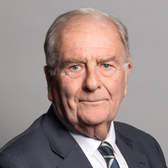 |
| Contact Details | Contact Sir Roger Gale |
| Political Party | Conservative |
What Council is the CT6 7UW Postcode in?
The Local Council for this Postcode is Canterbury District Council and the County Council is Kent County Council.
Kent County Council is responsible for providing education, libraries and maintaining highways.
Canterbury District Council is responsible for duties such as council tax, rubbish collection, housing, environmental health and planning.
You can visit the website for Canterbury District at the following link Canterbury District.How much is the Council Tax?
Canterbury District Council is responsible for collecting council tax. This will vary depending on which council tax band the property falls within. You can check the council tax band at the gov.uk website.
Once you know the council tax band you can view how much Canterbury District charge for that band by visiting the The Council Tax section of their website.
Planning Applications
When moving house to a new post code it is worth checking out what will be built in the neighbourhood.
Few people want to live next door to a building site, have their garden overlooked or have the views from their property ruined.
Visit the local planning department and search for planning applications in this postcode granted within the last three years or still awaiting a decision. This will give an indication of what could still be built.
Where can I find out where the nearest Library to the CT6 7UW Postcode is?
Libraries are the responsibility of Kent County Council
Visit the link for more information. Please note that some councils outsource library services to private companies and community groups ran by volunteers.
Libraries - Kent County CouncilPostcodes near the CT6 7UW Postcode
What Popular Supermarkets are near the CT6 7UW Postcode?
| Supermarket | Distance | Directions |
|---|---|---|
| Sainsburys, The Boulevard, Altira Business Park, HERNE BAY, CT6 6GZ | 0.79 miles | Directions from CT6 7UW to Sainsburys |
| Iceland, 155/157 Mortimer Street, Herne Bay, Kent, CT6 5HD | 2.01 miles | Directions from CT6 7UW to Iceland |
| Aldi, Kings Road, HERNE BAY, CT6 5RE | 2.02 miles | Directions from CT6 7UW to Aldi |
| Morrisons, Beach Street, HERNE BAY, CT6 5PU | 2.08 miles | Directions from CT6 7UW to Morrisons |
| Lidl, Woollets Close, HERNE BAY, CT6 8NZ | 2.66 miles | Directions from CT6 7UW to Lidl |
What Popular Restaurants are near the CT6 7UW Postcode?
| Burger King | Distance | Directions |
|---|---|---|
| Unit 1 The Clocktower, Canterbury, CT1 2LE | 6.00 miles | Directions from CT6 7UW to Unit 1 The Clocktower |
| Margate Road, Westwood, Broadstairs, CT10 2PR | 10.80 miles | Directions from CT6 7UW to Margate Road, Westwood |
| Neats Court Retail Park, Isle Of Sheppey, ME11 5AR | 17.08 miles | Directions from CT6 7UW to Neats Court Retail Park |
| St James Retail Park, Dover, CT16 1QD | 17.56 miles | Directions from CT6 7UW to St James Retail Park |
| Mcdonald's | Distance | Directions |
|---|---|---|
| McDonald's, Thanet Way, Chestfield, WHITSTABLE, CT5 3JE | 3.47 miles | Directions from CT6 7UW to McDonald's, Thanet Way, Chestfield, WHITSTABLE, CT5 3JE |
| McDonald's, Stour Retail Park, Stour Crescent, CANTERBURY, CT1 1AD | 4.65 miles | Directions from CT6 7UW to McDonald's, Stour Retail Park, Stour Crescent, CANTERBURY, CT1 1AD |
| McDonald's, St. Georges Street, CANTERBURY, CT1 2SS | 6.03 miles | Directions from CT6 7UW to McDonald's, St. Georges Street, CANTERBURY, CT1 2SS |
| McDonald's, Laundry Road, Minster, RAMSGATE, CT12 4EU | 7.51 miles | Directions from CT6 7UW to McDonald's, Laundry Road, Minster, RAMSGATE, CT12 4EU |
| Restaurant | Distance | Directions |
|---|---|---|
| KFC, Thanet Way, Chestfield, WHITSTABLE, CT5 3JE | 3.47 miles | Directions from CT6 7UW to KFC Whitstable - Highgate Park |
| KFC, Vauxhall Road, CANTERBURY, CT1 1ZG | 4.67 miles | Directions from CT6 7UW to KFC Canterbury - Maybrook Retail Park |
| KFC, St. Georges Street, CANTERBURY, CT1 2LE | 6.01 miles | Directions from CT6 7UW to KFC Canterbury - Whitefriars Shopping Centre |
| KFC, High Street, MARGATE, CT9 1DX | 10.43 miles | Directions from CT6 7UW to KFC Margate - High Street |
| KFC, Westwood Road, BROADSTAIRS, CT10 2AL | 11.65 miles | Directions from CT6 7UW to KFC Broadstairs - Westwood Retail Park |