The DH6 3 postcode sector is within the county of Durham.
Did you know? According to the 2021 Census, the DH6 3 postcode sector is home to a bustling 5,684 residents!
Given that each sector allows for 400 unique postcode combinations. Letters C, I, K, M, O and V are not allowed in the last two letters of a postcode. With 180 postcodes already in use, this leaves 220 units available.
The largest settlements in the DH6 3 postal code are Wheatley Hill and Thornley.
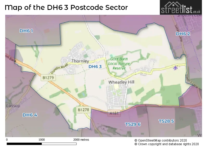
The DH6 3 Postcode shares a border with DH6 4 (Coxhoe, Kelloe, Quarrington Hill), TS28 5 (WINGATE, Station Town), TS29 6 (Trimdon, TRIMDON STATION, Trimdon Grange), DH6 1 (Sherburn Village, Sherburn Hill, High Pittington) and DH6 2 (Shotton Colliery, South Hetton, Haswell).
The sector is within the post town of DURHAM.
DH6 3 is a postcode sector within the DH6 postcode district which is within the DH Durham postcode area.
The Royal Mail delivery office for the DH6 3 postal sector is the Durham Delivery Office.
The area of the DH6 3 postcode sector is 3.90 square miles which is 10.10 square kilometres or 2,495.72 square acres.

Map of the DH6 3 Postcode Sector
Explore the DH6 3 postcode sector by using our free interactive map.
| D | H | 6 | - | 3 | X | X |
| D | H | 6 | Space | 3 | Letter | Letter |
Official List of Streets
Thornley (58 Streets)
Wheatley Hill (66 Streets)
Unofficial Streets or Alternative Spellings
Schools and Places of Education Within the DH6 3 Postcode Sector
Thornley Primary School
Community school
Cooper's Terrace, Durham, , DH6 3DZ
Head: Mrs Anna Caine
Ofsted Rating: Good
Inspection: 2018-12-07 (2006 days ago)
Website: Visit Thornley Primary School Website
Phone: 01429820280
Number of Pupils: 177
Wheatley Hill Community Primary School
Community school
Wheatley Hill Primary School, Durham, , DH6 3RQ
Head: Mr Alan Scarr
Ofsted Rating: Good
Inspection: 2023-10-06 (242 days ago)
Website: Visit Wheatley Hill Community Primary School Website
Phone: 01429820594
Number of Pupils: 415
House Prices in the DH6 3 Postcode Sector
| Type of Property | 2018 Average | 2018 Sales | 2017 Average | 2017 Sales | 2016 Average | 2016 Sales | 2015 Average | 2015 Sales |
|---|---|---|---|---|---|---|---|---|
| Detached | £173,143 | 43 | £166,628 | 23 | £127,501 | 40 | £131,893 | 24 |
| Semi-Detached | £68,196 | 41 | £69,798 | 54 | £73,275 | 51 | £72,808 | 34 |
| Terraced | £60,784 | 49 | £48,749 | 37 | £57,236 | 29 | £55,525 | 36 |
| Flats | £0 | 0 | £0 | 0 | £0 | 0 | £0 | 0 |
Important Postcodes DH6 3 in the Postcode Sector
DH6 3DZ is the postcode for Thornley Primary School, Coopers Terrace
DH6 3NR is the postcode for St. Godrics Primary School, Thornley Road
DH6 3RQ is the postcode for Wheatley Hill Primary School, Wheatley Hill
DH6 3RT is the postcode for Wheatley Hill Children's Centre, Jack Lawson Terrace
| The DH6 3 Sector is within these Local Authorities |
|
|---|---|
| The DH6 3 Sector is within these Counties |
|
| The DH6 3 Sector is within these Water Company Areas |
|