The DN14 0 postcode sector lies where the three counties of North Yorkshire, South Yorkshire, and East Riding of Yorkshire meet.
Did you know? According to the 2021 Census, the DN14 0 postcode sector is home to a bustling 7,853 residents!
Given that each sector allows for 400 unique postcode combinations. Letters C, I, K, M, O and V are not allowed in the last two letters of a postcode. With 311 postcodes already in use, this leaves 89 units available.
The largest settlement in the DN14 0 postal code is Eggborough followed by Whitley, and Hensall.
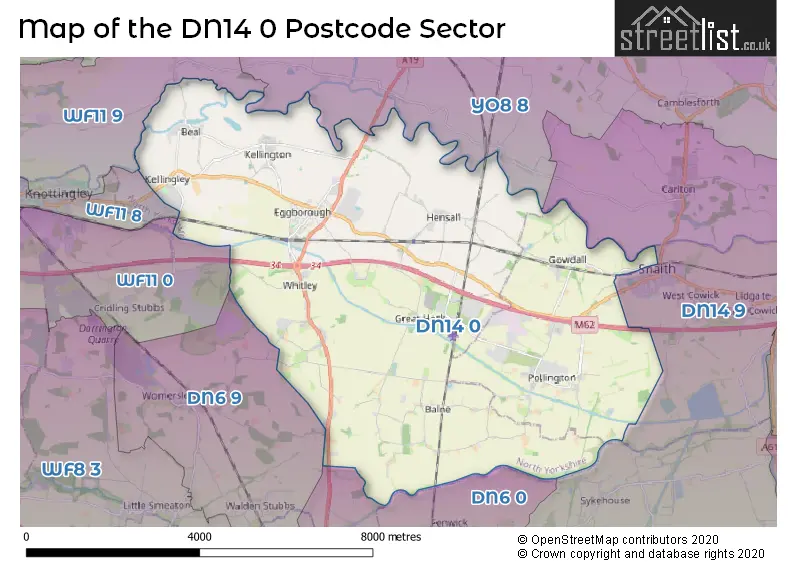
The DN14 0 Postcode shares a border with WF11 0 (KNOTTINGLEY, Cridling Stubbs, Ferrybridge), DN6 9 (Norton, Campsall, Womersley), DN14 9 (Carlton, Snaith, Sykehouse), WF11 8 (KNOTTINGLEY, Ferrybridge), WF11 9 (KNOTTINGLEY, Byram, Brotherton), YO8 8 (SELBY, Camblesforth, Barlow) and DN6 0 (Askern, Moss, Fenwick).
The sector is within the post town of GOOLE.
DN14 0 is a postcode sector within the DN14 postcode district which is within the DN Doncaster postcode area.
The Royal Mail delivery office for the DN14 0 postal sector is the Goole Delivery Office.
The area of the DN14 0 postcode sector is 26.92 square miles which is 69.71 square kilometres or 17,226.39 square acres.
The DN14 0 postcode sector is crossed by the M62 motorway.
Waterways within the DN14 0 postcode sector include the Aire & Calder Navigation, River Aire, River Went.

Map of the DN14 0 Postcode Sector
Explore the DN14 0 postcode sector by using our free interactive map.
| D | N | 1 | 4 | - | 0 | X | X |
| D | N | 1 | 4 | Space | 0 | Letter | Letter |
Official List of Streets
Whitley (28 Streets)
Eggborough (55 Streets)
Kellington (20 Streets)
Pollington (29 Streets)
Balne (13 Streets)
Beal (21 Streets)
Hensall (22 Streets)
Whitley Bridge (2 Streets)
Gowdall (7 Streets)
Snaith (2 Streets)
Little Heck (1 Streets)
Unofficial Streets or Alternative Spellings
Womersley
HIGHFIELD LANEEggborough
BRAEMAR COURTCridling Stubbs
COBCROFT LANEAskern
SELBY ROADSchools and Places of Education Within the DN14 0 Postcode Sector
Hensall Community Primary School
Community school
Church Lane, Near Goole, , DN14 0QQ
Head: Mrs Marie Clayton
Ofsted Rating: Good
Inspection: 2023-01-13 (496 days ago)
Website: Visit Hensall Community Primary School Website
Phone: 01977661340
Number of Pupils: 141
Kellington Primary School
Academy converter
Roall Lane, Goole, North Yorkshire, DN14 0NY
Head: Mrs Melanie Lawrence
Ofsted Rating: Requires improvement
Inspection: 2022-11-30 (540 days ago)
Website: Visit Kellington Primary School Website
Phone: 01977661127
Number of Pupils: 115
Pollington-Balne Church of England Primary School
Voluntary aided school
Balne Moor Road, Goole, , DN14 0DZ
Head: Mrs K Rawes
Ofsted Rating: Outstanding
Inspection: 2022-02-03 (840 days ago)
Website: Visit Pollington-Balne Church of England Primary School Website
Phone: 01405861916
Number of Pupils: 122
Whitley and Eggborough Community Primary School
Community school
Learning Lane, Goole, , DN14 0WE
Head: Mrs Alison Coventry
Ofsted Rating: Good
Inspection: 2023-11-08 (197 days ago)
Website: Visit Whitley and Eggborough Community Primary School Website
Phone: 01977661247
Number of Pupils: 224
House Prices in the DN14 0 Postcode Sector
| Type of Property | 2018 Average | 2018 Sales | 2017 Average | 2017 Sales | 2016 Average | 2016 Sales | 2015 Average | 2015 Sales |
|---|---|---|---|---|---|---|---|---|
| Detached | £248,094 | 64 | £245,862 | 96 | £242,794 | 94 | £226,524 | 80 |
| Semi-Detached | £149,971 | 50 | £160,355 | 40 | £140,252 | 42 | £141,543 | 40 |
| Terraced | £132,002 | 27 | £121,908 | 12 | £131,031 | 31 | £130,166 | 21 |
| Flats | £107,500 | 2 | £207,500 | 2 | £85,750 | 2 | £80,200 | 1 |
Important Postcodes DN14 0 in the Postcode Sector
DN14 0DZ is the postcode for Pollington Balne C of E School, Pollington
DN14 0NY is the postcode for Kellington Primary School, Roall Lane, Kellington, and Kellington Primary School, Roall Lane
DN14 0QQ is the postcode for Hensall Cp School, Church Lane, Hensall, and Hensall Cp School, Church Lane
DN14 0WE is the postcode for Whitley & Eggborough Cp School, Learning Lane, Whitley & Eggborough Cp School, Learning Lane, Whitley, and MAIN BUILDING, Whitley & Eggborough Cp School, Learning Lane
| The DN14 0 Sector is within these Local Authorities |
|
|---|---|
| The DN14 0 Sector is within these Counties |
|
| The DN14 0 Sector is within these Water Company Areas |
|