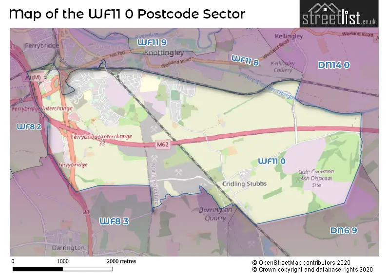
The WF11 0 postcode sector stands on the North Yorkshire and West Yorkshire border.
Did you know? According to the 2021 Census, the WF11 0 postcode sector is home to a bustling 6,912 residents!
Given that each sector allows for 400 unique postcode combinations. Letters C, I, K, M, O and V are not allowed in the last two letters of a postcode. With 161 postcodes already in use, this leaves 239 units available.
The largest settlement in the WF11 0 postal code is KNOTTINGLEY followed by Cridling Stubbs, and Ferrybridge.
The WF11 0 Postcode shares a border with DN6 9 (Norton, Campsall, Womersley), WF8 2 (PONTEFRACT), WF8 3 (PONTEFRACT, Darrington, Kirk Smeaton), WF11 8 (KNOTTINGLEY, Ferrybridge) and DN14 0 (Eggborough, Whitley, Hensall).
The sector is within the post town of KNOTTINGLEY.
WF11 0 is a postcode sector within the WF11 postcode district which is within the WF Wakefield postcode area.
The Royal Mail delivery office for the WF11 0 postal sector is the Pontefract Delivery Office.
The area of the WF11 0 postcode sector is 5.58 square miles which is 14.46 square kilometres or 3,573.52 square acres.
The WF11 0 postcode sector is crossed by the M62 motorway.
The WF11 0 postcode sector is crossed by the A1M Major A road.
The WF11 0 postcode sector is crossed by the A162 Major A road.
The WF11 0 postcode sector is crossed by the A1 Major A road.
Waterways within the WF11 0 postcode sector include the Aire & Calder Navigation.

Map of the WF11 0 Postcode Sector
Explore the WF11 0 postcode sector by using our free interactive map.
| W | F | 1 | 1 | - | 0 | X | X |
| W | F | 1 | 1 | Space | 0 | Letter | Letter |
Official List of Streets
KNOTTINGLEY (107 Streets)
Cridling Stubbs (7 Streets)
Ferrybridge (1 Streets)
Unofficial Streets or Alternative Spellings
KNOTTINGLEY
CHILTERN AVENUE COTSWOLD DRIVE RAINSBOROUGH AVENUE A1 BUSINESS PARK BEAL LANE BLACKBURN LANE FERRYBRIDGE BY-PASS FERRYBRIDGE INTERCHANGE HAWSWATER PLACE HODGEWOOD LANE LEYS LANE LEYS ROAD LOWSWATER ROAD RAMPART LANE SHILLINGHILL LANE SOUTHMOOR LANE STUBBS BRIDGEKNOTTINGLEY,
KNOTTINGLEY ROADWhitley
WHITEFIELD LANEBeal
SUDFORTH LANEWeather Forecast for WF11 0
Press Button to Show Forecast for Knottingley
| Time Period | Icon | Description | Temperature | Rain Probability | Wind |
|---|---|---|---|---|---|
| 03:00 to 06:00 | Cloudy | 13.0°C (feels like 13.0°C) | 4.00% | NE 2 mph | |
| 06:00 to 09:00 | Cloudy | 14.0°C (feels like 14.0°C) | 5.00% | SE 2 mph | |
| 09:00 to 12:00 | Cloudy | 18.0°C (feels like 18.0°C) | 4.00% | SSE 4 mph | |
| 12:00 to 15:00 | Cloudy | 21.0°C (feels like 21.0°C) | 4.00% | SSE 4 mph | |
| 15:00 to 18:00 | Cloudy | 22.0°C (feels like 21.0°C) | 4.00% | SE 4 mph | |
| 18:00 to 21:00 | Partly cloudy (day) | 21.0°C (feels like 20.0°C) | 1.00% | SE 7 mph | |
| 21:00 to 00:00 | Cloudy | 17.0°C (feels like 16.0°C) | 4.00% | SE 7 mph |
Press Button to Show Forecast for Knottingley
| Time Period | Icon | Description | Temperature | Rain Probability | Wind |
|---|---|---|---|---|---|
| 00:00 to 03:00 | Partly cloudy (night) | 15.0°C (feels like 14.0°C) | 2.00% | SE 7 mph | |
| 03:00 to 06:00 | Clear night | 13.0°C (feels like 13.0°C) | 1.00% | SSE 4 mph | |
| 06:00 to 09:00 | Partly cloudy (day) | 14.0°C (feels like 14.0°C) | 0.00% | SSE 4 mph | |
| 09:00 to 12:00 | Partly cloudy (day) | 18.0°C (feels like 18.0°C) | 1.00% | SE 4 mph | |
| 12:00 to 15:00 | Partly cloudy (day) | 21.0°C (feels like 20.0°C) | 3.00% | SSE 9 mph | |
| 15:00 to 18:00 | Partly cloudy (day) | 22.0°C (feels like 20.0°C) | 3.00% | SSE 9 mph | |
| 18:00 to 21:00 | Cloudy | 21.0°C (feels like 19.0°C) | 5.00% | SE 9 mph | |
| 21:00 to 00:00 | Partly cloudy (night) | 16.0°C (feels like 15.0°C) | 1.00% | SE 9 mph |
Press Button to Show Forecast for Knottingley
| Time Period | Icon | Description | Temperature | Rain Probability | Wind |
|---|---|---|---|---|---|
| 00:00 to 03:00 | Partly cloudy (night) | 14.0°C (feels like 13.0°C) | 1.00% | SE 7 mph | |
| 03:00 to 06:00 | Partly cloudy (night) | 12.0°C (feels like 11.0°C) | 1.00% | SE 4 mph | |
| 06:00 to 09:00 | Partly cloudy (day) | 13.0°C (feels like 12.0°C) | 1.00% | ESE 4 mph | |
| 09:00 to 12:00 | Partly cloudy (day) | 17.0°C (feels like 16.0°C) | 1.00% | ESE 4 mph | |
| 12:00 to 15:00 | Cloudy | 21.0°C (feels like 20.0°C) | 4.00% | SE 9 mph | |
| 15:00 to 18:00 | Cloudy | 22.0°C (feels like 20.0°C) | 13.00% | SSE 9 mph | |
| 18:00 to 21:00 | Light rain shower (day) | 20.0°C (feels like 19.0°C) | 34.00% | SSE 9 mph | |
| 21:00 to 00:00 | Light rain | 17.0°C (feels like 16.0°C) | 41.00% | SE 7 mph |
Press Button to Show Forecast for Knottingley
| Time Period | Icon | Description | Temperature | Rain Probability | Wind |
|---|---|---|---|---|---|
| 00:00 to 03:00 | Cloudy | 15.0°C (feels like 14.0°C) | 10.00% | SSE 7 mph | |
| 03:00 to 06:00 | Cloudy | 14.0°C (feels like 13.0°C) | 11.00% | SW 4 mph | |
| 06:00 to 09:00 | Cloudy | 14.0°C (feels like 13.0°C) | 17.00% | S 7 mph | |
| 09:00 to 12:00 | Cloudy | 16.0°C (feels like 15.0°C) | 18.00% | S 7 mph | |
| 12:00 to 15:00 | Cloudy | 18.0°C (feels like 16.0°C) | 19.00% | S 9 mph | |
| 15:00 to 18:00 | Light rain shower (day) | 18.0°C (feels like 17.0°C) | 40.00% | S 9 mph | |
| 18:00 to 21:00 | Light rain shower (day) | 17.0°C (feels like 15.0°C) | 35.00% | S 9 mph | |
| 21:00 to 00:00 | Light rain shower (night) | 14.0°C (feels like 13.0°C) | 42.00% | SSW 7 mph |
Schools and Places of Education Within the WF11 0 Postcode Sector
De Lacy Academy
Academy converter
Middle Lane, Knottingley, West Yorkshire, WF11 0BZ
Head: Mrs Hellen O'Brien
Ofsted Rating: Outstanding
Inspection: 2022-04-06 (765 days ago)
Website: Visit De Lacy Academy Website
Phone: 01977722489
Number of Pupils: 816
England Lane Academy
Academy sponsor led
England Lane, Knottingley, West Yorkshire, WF11 0JA
Head: Headteacher David Irving
Ofsted Rating: Good
Inspection: 2019-03-14 (1884 days ago)
Website: Visit England Lane Academy Website
Phone: 01977722486
Number of Pupils: 209
Simpson's Lane Academy
Academy converter
Sycamore Avenue, Knottingley, West Yorkshire, WF11 0PL
Head: Mr Lee Colley
Ofsted Rating: Good
Inspection: 2019-12-12 (1611 days ago)
Website: Visit Simpson's Lane Academy Website
Phone: 01977722515
Number of Pupils: 378
House Prices in the WF11 0 Postcode Sector
| Type of Property | 2018 Average | 2018 Sales | 2017 Average | 2017 Sales | 2016 Average | 2016 Sales | 2015 Average | 2015 Sales |
|---|---|---|---|---|---|---|---|---|
| Detached | £187,679 | 21 | £171,383 | 31 | £163,894 | 40 | £200,120 | 11 |
| Semi-Detached | £114,932 | 83 | £108,844 | 76 | £109,058 | 68 | £109,386 | 57 |
| Terraced | £95,673 | 20 | £78,260 | 19 | £76,437 | 16 | £81,031 | 16 |
| Flats | £53,000 | 1 | £0 | 0 | £0 | 0 | £48,750 | 2 |
Important Postcodes WF11 0 in the Postcode Sector
WF11 0BZ is the postcode for BLOCK B, De Lacy Academy, Middle Lane, BLOCK C, De Lacy Academy, Middle Lane, BLOCK R, De Lacy Academy, Middle Lane, BLOCK E, De Lacy Academy, Middle Lane, BLOCK A, De Lacy Academy, Middle Lane, BLOCK U, De Lacy Academy, Middle Lane, GYM, De Lacy Academy, Middle Lane, and SPORTS HALL, De Lacy Academy, Middle Lane
WF11 0EP is the postcode for Education House, Spawd Bone Lane
WF11 0JA is the postcode for England Lane Academy, England Lane
WF11 0LG is the postcode for Hazel Garth, Hazel Road
WF11 0PA is the postcode for Throstle Farm School, Hazel Road
WF11 0PJ is the postcode for Simpson Lane Academy, Sycamore Avenue
| The WF11 0 Sector is within these Local Authorities |
|
|---|---|
| The WF11 0 Sector is within these Counties |
|
| The WF11 0 Sector is within these Water Company Areas |
|