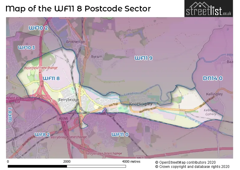
The WF11 8 postcode sector stands on the North Yorkshire and West Yorkshire border.
Did you know? According to the 2021 Census, the WF11 8 postcode sector is home to a bustling 6,443 residents!
Given that each sector allows for 400 unique postcode combinations. Letters C, I, K, M, O and V are not allowed in the last two letters of a postcode. With 208 postcodes already in use, this leaves 192 units available.
The largest settlements in the WF11 8 postal code are KNOTTINGLEY and Ferrybridge.
The WF11 8 Postcode shares a border with WF10 3 (CASTLEFORD), WF11 0 (KNOTTINGLEY, Cridling Stubbs, Ferrybridge), WF8 2 (PONTEFRACT), WF10 2 (Allerton Bywater, CASTLEFORD, Ledston), WF11 9 (KNOTTINGLEY, Byram, Brotherton) and DN14 0 (Eggborough, Whitley, Hensall).
The sector is within the post town of KNOTTINGLEY.
WF11 8 is a postcode sector within the WF11 postcode district which is within the WF Wakefield postcode area.
The Royal Mail delivery office for the WF11 8 postal sector is the Pontefract Delivery Office.
The area of the WF11 8 postcode sector is 2.66 square miles which is 6.89 square kilometres or 1,702.74 square acres.
The WF11 8 postcode sector is crossed by the A1M Major A road.
The WF11 8 postcode sector is crossed by the M62 motorway.
Waterways within the WF11 8 postcode sector include the Aire & Calder Navigation, River Aire.

Map of the WF11 8 Postcode Sector
Explore the WF11 8 postcode sector by using our free interactive map.
| W | F | 1 | 1 | - | 8 | X | X |
| W | F | 1 | 1 | Space | 8 | Letter | Letter |
Official List of Streets
KNOTTINGLEY (130 Streets)
Unofficial Streets or Alternative Spellings
Beal
SUDFORTH LANE WEELAND ROADKNOTTINGLEY
CATTLELAITH LANE COW LANE HEADLANDS LANE MARSH END PLOWES WAY SEATON CRESCENT WARREN AVENUE BEULAH COURT BLACKBURN LANE FERRY BRIDGE FERRYBRIDGE BY-PASS FERRYBRIDGE BYPASS HEALTH AND SAFETY WAY HINTON LANE HOLES LANES MILL BRIDGE NEW ROAD NEWLAND STREET RAMPART LANE SOUTHMOOR LANE SPRINGFIELDS AVENUE SPURRIERS AVENUE TRUNDLES LANE VALE CRESTFerrybridge
SOWGATE LANECASTLEFORD
SHEEPWALK LANEWeather Forecast for WF11 8
Press Button to Show Forecast for Wheldale
| Time Period | Icon | Description | Temperature | Rain Probability | Wind |
|---|---|---|---|---|---|
| 15:00 to 18:00 | Cloudy | 9.0°C (feels like 7.0°C) | 8.00% | ENE 7 mph | |
| 18:00 to 21:00 | Cloudy | 7.0°C (feels like 5.0°C) | 29.00% | E 7 mph | |
| 21:00 to 00:00 | Cloudy | 6.0°C (feels like 4.0°C) | 5.00% | ENE 7 mph |
Press Button to Show Forecast for Wheldale
| Time Period | Icon | Description | Temperature | Rain Probability | Wind |
|---|---|---|---|---|---|
| 00:00 to 03:00 | Partly cloudy (night) | 4.0°C (feels like 2.0°C) | 1.00% | NE 4 mph | |
| 03:00 to 06:00 | Partly cloudy (night) | 3.0°C (feels like 0.0°C) | 1.00% | NNE 7 mph | |
| 06:00 to 09:00 | Cloudy | 3.0°C (feels like 1.0°C) | 5.00% | NNE 7 mph | |
| 09:00 to 12:00 | Cloudy | 8.0°C (feels like 6.0°C) | 13.00% | NE 9 mph | |
| 12:00 to 15:00 | Overcast | 9.0°C (feels like 6.0°C) | 16.00% | ENE 9 mph | |
| 15:00 to 18:00 | Overcast | 9.0°C (feels like 7.0°C) | 19.00% | ENE 9 mph | |
| 18:00 to 21:00 | Cloudy | 8.0°C (feels like 6.0°C) | 9.00% | ENE 9 mph | |
| 21:00 to 00:00 | Cloudy | 6.0°C (feels like 4.0°C) | 6.00% | NE 7 mph |
Press Button to Show Forecast for Wheldale
| Time Period | Icon | Description | Temperature | Rain Probability | Wind |
|---|---|---|---|---|---|
| 00:00 to 03:00 | Cloudy | 5.0°C (feels like 2.0°C) | 7.00% | NNE 9 mph | |
| 03:00 to 06:00 | Overcast | 5.0°C (feels like 2.0°C) | 13.00% | N 9 mph | |
| 06:00 to 09:00 | Light rain | 6.0°C (feels like 2.0°C) | 55.00% | N 11 mph | |
| 09:00 to 12:00 | Light rain | 7.0°C (feels like 3.0°C) | 54.00% | N 11 mph | |
| 12:00 to 15:00 | Light rain | 8.0°C (feels like 5.0°C) | 51.00% | NW 11 mph | |
| 15:00 to 18:00 | Cloudy | 10.0°C (feels like 8.0°C) | 15.00% | WNW 9 mph | |
| 18:00 to 21:00 | Partly cloudy (day) | 10.0°C (feels like 8.0°C) | 7.00% | W 9 mph | |
| 21:00 to 00:00 | Clear night | 7.0°C (feels like 5.0°C) | 2.00% | WSW 7 mph |
Press Button to Show Forecast for Wheldale
| Time Period | Icon | Description | Temperature | Rain Probability | Wind |
|---|---|---|---|---|---|
| 00:00 to 03:00 | Clear night | 6.0°C (feels like 4.0°C) | 1.00% | SW 7 mph | |
| 03:00 to 06:00 | Clear night | 5.0°C (feels like 3.0°C) | 1.00% | SSW 7 mph | |
| 06:00 to 09:00 | Sunny day | 6.0°C (feels like 4.0°C) | 1.00% | S 7 mph | |
| 09:00 to 12:00 | Sunny day | 11.0°C (feels like 8.0°C) | 1.00% | S 11 mph | |
| 12:00 to 15:00 | Partly cloudy (day) | 13.0°C (feels like 11.0°C) | 2.00% | S 13 mph | |
| 15:00 to 18:00 | Cloudy | 14.0°C (feels like 12.0°C) | 6.00% | S 13 mph | |
| 18:00 to 21:00 | Partly cloudy (day) | 13.0°C (feels like 11.0°C) | 2.00% | SSE 11 mph | |
| 21:00 to 00:00 | Clear night | 11.0°C (feels like 9.0°C) | 2.00% | SE 9 mph |
Press Button to Show Forecast for Wheldale
| Time Period | Icon | Description | Temperature | Rain Probability | Wind |
|---|---|---|---|---|---|
| 00:00 to 03:00 | Clear night | 9.0°C (feels like 7.0°C) | 1.00% | SE 9 mph | |
| 03:00 to 06:00 | Partly cloudy (night) | 7.0°C (feels like 5.0°C) | 2.00% | ESE 7 mph | |
| 06:00 to 09:00 | Cloudy | 8.0°C (feels like 6.0°C) | 5.00% | ESE 7 mph | |
| 09:00 to 12:00 | Partly cloudy (day) | 12.0°C (feels like 10.0°C) | 4.00% | ESE 9 mph | |
| 12:00 to 15:00 | Cloudy | 15.0°C (feels like 13.0°C) | 10.00% | ESE 11 mph | |
| 15:00 to 18:00 | Cloudy | 16.0°C (feels like 13.0°C) | 12.00% | ESE 11 mph | |
| 18:00 to 21:00 | Partly cloudy (day) | 14.0°C (feels like 12.0°C) | 11.00% | E 9 mph | |
| 21:00 to 00:00 | Cloudy | 11.0°C (feels like 10.0°C) | 11.00% | E 7 mph |
Schools and Places of Education Within the WF11 8 Postcode Sector
The Vale Primary Academy
Academy converter
Ferrybridge Road, Knottingley, West Yorkshire, WF11 8JF
Head: Sally Cartwright
Ofsted Rating: Outstanding
Inspection: 2013-05-09 (4005 days ago)
Website: Visit The Vale Primary Academy Website
Phone: 01977722485
Number of Pupils: 239
Willow Green Academy
Academy sponsor led
Hampden Close, Knottingley, West Yorkshire, WF11 8PT
Head: Chris Parkinson
Ofsted Rating: Good
Inspection: 2023-09-13 (226 days ago)
Website: Visit Willow Green Academy Website
Phone: 01977722487
Number of Pupils: 226
House Prices in the WF11 8 Postcode Sector
| Type of Property | 2018 Average | 2018 Sales | 2017 Average | 2017 Sales | 2016 Average | 2016 Sales | 2015 Average | 2015 Sales |
|---|---|---|---|---|---|---|---|---|
| Detached | £193,653 | 13 | £165,795 | 10 | £156,208 | 12 | £176,750 | 8 |
| Semi-Detached | £116,716 | 53 | £114,287 | 60 | £111,125 | 52 | £106,651 | 44 |
| Terraced | £92,828 | 32 | £87,917 | 39 | £98,395 | 38 | £88,946 | 29 |
| Flats | £40,000 | 1 | £73,500 | 2 | £0 | 0 | £89,667 | 3 |
Important Postcodes WF11 8 in the Postcode Sector
WF11 8EE is the postcode for Knottingley Sports Centre, Hill Top
WF11 8ER is the postcode for The Grove, Marine Villa Road
WF11 8JF is the postcode for The Vale Primary Academy, Ferrybridge Road
WF11 8NJ is the postcode for Beauforth House, Station Road
WF11 8NQ is the postcode for 8-10, High Street
WF11 8PT is the postcode for Willow Green Academy, Hampden Close, and Roundhill Junior School, Hampden Close
WF11 8RN is the postcode for The Railway, 88 Pontefract Road
| The WF11 8 Sector is within these Local Authorities |
|
|---|---|
| The WF11 8 Sector is within these Counties |
|
| The WF11 8 Sector is within these Water Company Areas |
|