The DN36 5 postcode sector is within the county of Lincolnshire.
Did you know? According to the 2021 Census, the DN36 5 postcode sector is home to a bustling 8,577 residents!
Given that each sector allows for 400 unique postcode combinations. Letters C, I, K, M, O and V are not allowed in the last two letters of a postcode. With 282 postcodes already in use, this leaves 118 units available.
The largest settlement in the DN36 5 postal code is Holton-le-Clay followed by Tetney, and North Thoresby.
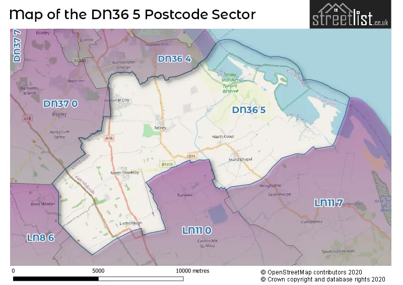
The DN36 5 Postcode shares a border with DN36 4 (Humberston, New Waltham), DN37 0 (Waltham, Barnoldby-le-Beck, Ashby-cum-Fenby), LN8 6 (Binbrook, Ludford, Benniworth), LN11 0 (LOUTH, Fulstow, Fotherby) and LN11 7 (North Somercotes, Saltfleet, LOUTH).
The sector is within the post town of GRIMSBY.
DN36 5 is a postcode sector within the DN36 postcode district which is within the DN Doncaster postcode area.
The Royal Mail delivery office for the DN36 5 postal sector is the Grimsby Delivery Office.
The area of the DN36 5 postcode sector is 35.55 square miles which is 92.08 square kilometres or 22,753.59 square acres.
Waterways within the DN36 5 postcode sector include the Louth Navigatio.

Map of the DN36 5 Postcode Sector
Explore the DN36 5 postcode sector by using our free interactive map.
| D | N | 3 | 6 | - | 5 | X | X |
| D | N | 3 | 6 | Space | 5 | Letter | Letter |
Official List of Streets
Holton-le-Clay (65 Streets)
North Thoresby (28 Streets)
Tetney (46 Streets)
Ludborough (5 Streets)
Marshchapel (21 Streets)
Waithe (2 Streets)
North Cotes (15 Streets)
Grainsby (1 Streets)
Unofficial Streets or Alternative Spellings
Grainthorpe
WRAGHOLME ROADFulstow
PEAR TREE LANE STATION ROAD THORESBY ROADFotherby
MAIN ROADWaltham
CHEAPSIDEAshby-cum-Fenby
BARTON STREETWragholme
FIREBEACON LANEHumberston
TETNEY ROADBrigsley
WAITHE LANESchools and Places of Education Within the DN36 5 Postcode Sector
Holton Le Clay Infant School
Community school
Church Lane, Nr Grimsby, Lincolnshire, DN36 5AQ
Head: Mrs Dawne Hunt
Ofsted Rating: Good
Inspection: 2017-02-21 (2648 days ago)
Website: Visit Holton Le Clay Infant School Website
Phone: 01472822065
Number of Pupils: 88
Holton-le-Clay Junior School
Community school
Picksley Crescent, Grimsby, Lincolnshire, DN36 5DR
Head: Mrs Dawne Hunt
Ofsted Rating: Good
Inspection: 2018-11-01 (2030 days ago)
Website: Visit Holton-le-Clay Junior School Website
Phone: 01472826432
Number of Pupils: 123
Marshchapel Infant School
Community school
Sea Dyke Way, Grimsby, Lincolnshire, DN36 5SX
Head: Mrs Amanda Turner
Ofsted Rating: Good
Inspection: 2019-03-06 (1905 days ago)
Website: Visit Marshchapel Infant School Website
Phone: 01472869075
Number of Pupils: 29
North Thoresby Primary Academy
Academy converter
High Street, Grimsby, Lincolnshire, DN36 5PL
Head: Mr Tom Hawkins
Ofsted Rating: Good
Inspection: 2020-01-21 (1584 days ago)
Website: Visit North Thoresby Primary Academy Website
Phone: 01472840295
Number of Pupils: 102
Tetney Primary School
Community school
Humberston Road, Grimsby, Lincolnshire, DN36 5NG
Head: Headteacher Chris Rayner
Ofsted Rating: Good
Inspection: 2018-11-08 (2023 days ago)
Website: Visit Tetney Primary School Website
Phone: 01472812074
Number of Pupils: 110
The North Cotes Church of England Primary School
Voluntary controlled school
Sea Lane, North Cotes, Lincolnshire, DN36 5UZ
Head: Mr Jonathan Grant
Ofsted Rating: Good
Inspection: 2023-11-02 (203 days ago)
Website: Visit The North Cotes Church of England Primary School Website
Phone: 01472388379
Number of Pupils: 32
House Prices in the DN36 5 Postcode Sector
| Type of Property | 2018 Average | 2018 Sales | 2017 Average | 2017 Sales | 2016 Average | 2016 Sales | 2015 Average | 2015 Sales |
|---|---|---|---|---|---|---|---|---|
| Detached | £233,982 | 112 | £231,551 | 98 | £215,430 | 95 | £223,978 | 90 |
| Semi-Detached | £149,769 | 77 | £144,636 | 46 | £134,248 | 44 | £127,379 | 40 |
| Terraced | £111,571 | 14 | £80,875 | 12 | £80,896 | 15 | £93,139 | 14 |
| Flats | £79,071 | 7 | £100,250 | 4 | £109,167 | 3 | £65,667 | 3 |
Important Postcodes DN36 5 in the Postcode Sector
DN36 5AQ is the postcode for HOLTON LE CLAY INFANTS SCHOOL, CHURCH LANE, and Holton-le-Clay Infants School, Church Lane
DN36 5DR is the postcode for Holton Le Clay Junior School, Picksley Crescent, Holton-le-Clay, and Holton Le Clay Junior School, Picksley Crescent
DN36 5NG is the postcode for Tetney Primary School, Humberston Road
DN36 5PL is the postcode for North Thoresby Primary School, High Street
DN36 5SX is the postcode for Marshchapel Primary School, Sea Dyke Way
DN36 5UZ is the postcode for North Cotes C of E School, Sea Lane, North Cotes, and North Cotes C of E School, Sea Lane
| The DN36 5 Sector is within these Local Authorities |
|
|---|---|
| The DN36 5 Sector is within these Counties |
|
| The DN36 5 Sector is within these Water Company Areas |
|
Tourist Attractions within the DN36 5 Postcode Area
We found 1 visitor attractions within the DN36 postcode area
| Lincolnshire Wolds Railway |
|---|
| Railways |
| Steam / Heritage Railway |
| View Lincolnshire Wolds Railway on Google Maps |