The GL11 6 postcode sector is within the county of Gloucestershire.
Did you know? According to the 2021 Census, the GL11 6 postcode sector is home to a bustling 3,852 residents!
Given that each sector allows for 400 unique postcode combinations. Letters C, I, K, M, O and V are not allowed in the last two letters of a postcode. With 143 postcodes already in use, this leaves 257 units available.
The largest settlement in the GL11 6 postal code is DURSLEY followed by North Nibley, and Stinchcombe.
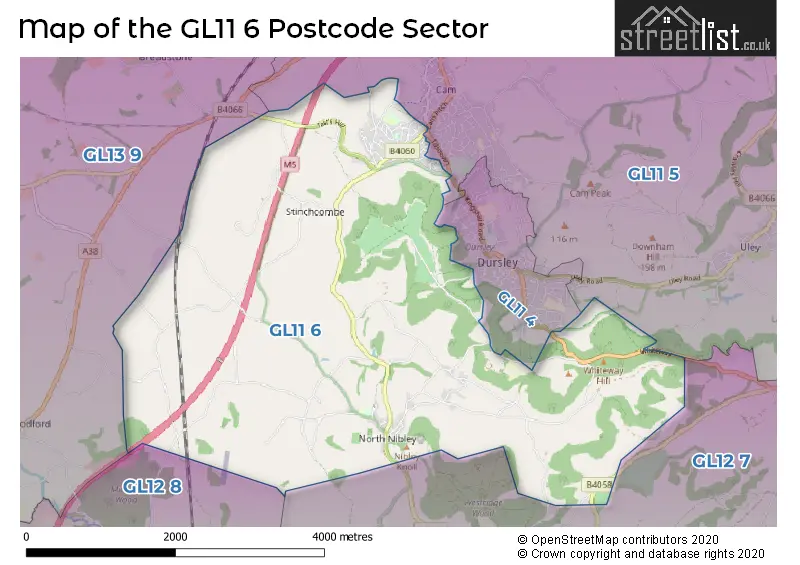
The GL11 6 Postcode shares a border with GL12 7 (WOTTON-UNDER-EDGE, Hillesley, Coombe), GL12 8 (Charfield, Wickwar, Kingswood), GL13 9 (BERKELEY, Newtown, Stone), GL11 4 (DURSLEY, Woodmancote) and GL11 5 (Cam, Uley, DURSLEY).
The sector is within the post town of DURSLEY.
GL11 6 is a postcode sector within the GL11 postcode district which is within the GL Gloucester postcode area.
The Royal Mail delivery office for the GL11 6 postal sector is the Dursley Delivery Office.
The area of the GL11 6 postcode sector is 9.61 square miles which is 24.90 square kilometres or 6,152.38 square acres.
The GL11 6 postcode sector is crossed by the M5 motorway.


Map of the GL11 6 Postcode Sector
Explore the GL11 6 postcode sector by using our free interactive map.
| G | L | 1 | 1 | - | 6 | X | X |
| G | L | 1 | 1 | Space | 6 | Letter | Letter |
Official List of Streets
North Nibley (19 Streets)
Stinchcombe (10 Streets)
DURSLEY (34 Streets)
Woodfield (1 Streets)
Sandpits (1 Streets)
Unofficial Streets or Alternative Spellings
DURSLEY
FIVE ACRES KINGSHILL ROAD TILSDOWN WORKMANS CLOSE CHAPEL COURT CHURCH LANE CLINGRE DOWN CNN24 CNN25 CNN33 CNN48 ECHO LANE GANZELL LANE LISTERS DRIVE LOWERHOUSE LANE MICHAEL WOOD SERVICES ACCESS ROAD MICHAELWOOD SERVICES NORTHBOUND MICHAELWOOD SERVICES SOUTHBOUND OLDHILL LANE ORCHARD VIEW RENISHAW DRIVE SHEEP PATH LANE SNITEND LANE TIMOTHY LANE TRUST RIDE WAREND HILL WOOD LANE WOODMANCOTE YEWTREE CLOSEBERKELEY
BERKELEY ROADWOTTON-UNDER-EDGE
OLD LONDON ROADNorth Nibley
CHURCH LANEAlkington
HAYCROFT LANESchools and Places of Education Within the GL11 6 Postcode Sector
Cam Woodfield Infant School
Community school
Elstub Lane, Dursley, Gloucestershire, GL11 6JJ
Head: Mrs Helen Harper
Ofsted Rating: Good
Inspection: 2018-09-26 (2080 days ago)
Website: Visit Cam Woodfield Infant School Website
Phone: 01453543535
Number of Pupils: 142
Cam Woodfield Junior School
Academy sponsor led
Elstub Lane, Dursley, , GL11 6JJ
Head: Mrs Louise Bennett
Ofsted Rating: Good
Inspection: 2022-05-25 (743 days ago)
Website: Visit Cam Woodfield Junior School Website
Phone: 01453542706
Number of Pupils: 194
North Nibley CofE Primary School
Voluntary aided school
The Street, Wotton-Under-Edge, Gloucestershire, GL11 6DL
Head: Mr Steven Hodgkinson
Ofsted Rating: Good
Inspection: 2023-04-26 (407 days ago)
Website: Visit North Nibley CofE Primary School Website
Phone: 01453542600
Number of Pupils: 110
House Prices in the GL11 6 Postcode Sector
| Type of Property | 2018 Average | 2018 Sales | 2017 Average | 2017 Sales | 2016 Average | 2016 Sales | 2015 Average | 2015 Sales |
|---|---|---|---|---|---|---|---|---|
| Detached | £400,054 | 23 | £363,950 | 20 | £398,630 | 23 | £378,938 | 30 |
| Semi-Detached | £260,021 | 19 | £313,010 | 10 | £203,157 | 15 | £208,765 | 25 |
| Terraced | £194,343 | 16 | £193,190 | 5 | £202,500 | 8 | £163,250 | 8 |
| Flats | £132,500 | 2 | £0 | 0 | £139,950 | 1 | £100,667 | 3 |
Important Postcodes GL11 6 in the Postcode Sector
GL11 6JJ is the postcode for Cam Woodfield Junior School, Elstub Lane, and Woodfield Infant School, Field Lane
| The GL11 6 Sector is within these Local Authorities |
|
|---|---|
| The GL11 6 Sector is within these Counties |
|
| The GL11 6 Sector is within these Water Company Areas |
|