The HP16 postcode district is a postal district located in the HP Hemel Hempstead postcode area with a population of 11,722 residents according to the 2021 England and Wales Census.
The area of the HP16 postcode district is 18.87 square miles which is 48.89 square kilometres or 12,079.81 acres.
Currently, the HP16 district has about 372 postcode units spread across 2 geographic postcode sectors.
Given that each sector allows for 400 unique postcode combinations, the district has a capacity of 800 postcodes. With 372 postcodes already in use, this leaves 428 units available.
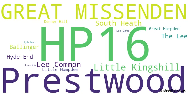
The largest settlement in the HP16 postal code is Prestwood followed by GREAT MISSENDEN, and Little Kingshill.
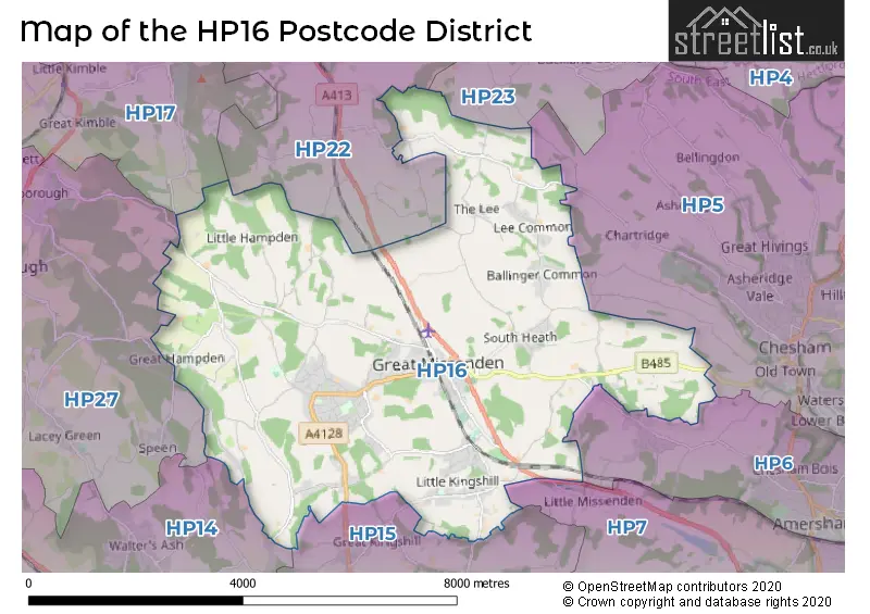
The HP16 Postcode shares a border with HP27 (PRINCES RISBOROUGH, Longwick, Monks Risborough), HP14 (Stokenchurch, Lane End, Walters Ash), HP15 (Hazlemere, Holmer Green, Great Kingshill), HP6 (AMERSHAM, Hyde Heath, LITTLE CHALFONT), HP7 (AMERSHAM, Coleshill, Winchmore Hill), HP23 (TRING, Wigginton, Long Marston), HP5 (CHESHAM, Ashley Green, Bellingdon) and HP22 (Wendover, Aston Clinton, Weston Turville).
The primary settlement in the HP16 postcode district is Great Missenden in Buckinghamshire, England. Other significant settlements include Ballinger, Denner Hill, Hyde End, Hyde Heath, Little Kingshill, Prestwood, and South Heath, all within Buckinghamshire. The most significant post town in the district is also Great Missenden.
For the district HP16, we have data on 3 postcode sectors. Here's a breakdown: The sector HP16 0, covers Prestwood and Great Missenden and Little Kingshill in Buckinghamshire. The sector HP16 6 is non-geographic. It's often designated for PO Boxes, large organisations, or special services. The sector HP16 9, covers Prestwood and Great Missenden in Buckinghamshire.

Map of the HP16 Postcode District
Explore the HP16 postcode district by using our free interactive map.
When it comes to local government, postal geography often disregards political borders. However, for a breakdown in the HP16 District: the district mostly encompasses the Buckinghamshire area with a total of 377 postcodes.
Recent House Sales in HP16
| Date | Price | Address |
|---|---|---|
| 06/10/2023 | £700,000 | Stocklands Way, Prestwood, Great Missenden, HP16 0SJ |
| 03/10/2023 | £590,000 | Old Town Farm, Great Missenden, HP16 9PA |
| 08/09/2023 | £480,000 | Church Street, Great Missenden, HP16 0AX |
| 08/09/2023 | £950,000 | High Street, Prestwood, Great Missenden, HP16 9EN |
| 07/09/2023 | £400,000 | High Street, Great Missenden, HP16 9AB |
| 01/09/2023 | £995,000 | New Road, Little Kingshill, Great Missenden, HP16 0EZ |
| 30/08/2023 | £495,000 | Abbey Walk, Great Missenden, HP16 0AY |
| 25/08/2023 | £510,000 | Rignall Road, Great Missenden, HP16 9AN |
| 25/08/2023 | £587,500 | Honor End Lane, Prestwood, Great Missenden, HP16 9QY |
| 18/08/2023 | £290,000 | Giles Gate, Prestwood, Great Missenden, HP16 0PH |
Weather Forecast for HP16
Press Button to Show Forecast for Raf High Wycombe
| Time Period | Icon | Description | Temperature | Rain Probability | Wind |
|---|---|---|---|---|---|
| 03:00 to 06:00 | Cloudy | 3.0°C (feels like -1.0°C) | 4.00% | ENE 7 mph | |
| 06:00 to 09:00 | Cloudy | 3.0°C (feels like -1.0°C) | 4.00% | ENE 9 mph | |
| 09:00 to 12:00 | Sunny day | 6.0°C (feels like 3.0°C) | 2.00% | ENE 9 mph | |
| 12:00 to 15:00 | Overcast | 9.0°C (feels like 7.0°C) | 11.00% | ENE 7 mph | |
| 15:00 to 18:00 | Overcast | 9.0°C (feels like 8.0°C) | 14.00% | ENE 4 mph | |
| 18:00 to 21:00 | Cloudy | 8.0°C (feels like 7.0°C) | 12.00% | NE 4 mph | |
| 21:00 to 00:00 | Cloudy | 6.0°C (feels like 3.0°C) | 12.00% | ENE 7 mph |
Press Button to Show Forecast for Raf High Wycombe
| Time Period | Icon | Description | Temperature | Rain Probability | Wind |
|---|---|---|---|---|---|
| 00:00 to 03:00 | Cloudy | 4.0°C (feels like 1.0°C) | 13.00% | E 7 mph | |
| 03:00 to 06:00 | Cloudy | 3.0°C (feels like 0.0°C) | 15.00% | ENE 7 mph | |
| 06:00 to 09:00 | Light rain | 4.0°C (feels like 1.0°C) | 51.00% | ENE 9 mph | |
| 09:00 to 12:00 | Overcast | 7.0°C (feels like 4.0°C) | 21.00% | ENE 9 mph | |
| 12:00 to 15:00 | Overcast | 10.0°C (feels like 8.0°C) | 19.00% | E 9 mph | |
| 15:00 to 18:00 | Cloudy | 11.0°C (feels like 8.0°C) | 18.00% | ENE 11 mph | |
| 18:00 to 21:00 | Light rain | 9.0°C (feels like 7.0°C) | 52.00% | ENE 9 mph | |
| 21:00 to 00:00 | Light rain | 8.0°C (feels like 4.0°C) | 52.00% | NE 11 mph |
Press Button to Show Forecast for Raf High Wycombe
| Time Period | Icon | Description | Temperature | Rain Probability | Wind |
|---|---|---|---|---|---|
| 00:00 to 03:00 | Heavy rain | 7.0°C (feels like 3.0°C) | 75.00% | NE 11 mph | |
| 03:00 to 06:00 | Heavy rain | 7.0°C (feels like 4.0°C) | 76.00% | NE 9 mph | |
| 06:00 to 09:00 | Light rain | 7.0°C (feels like 5.0°C) | 54.00% | ESE 7 mph | |
| 09:00 to 12:00 | Light rain shower (day) | 9.0°C (feels like 7.0°C) | 41.00% | ESE 7 mph | |
| 12:00 to 15:00 | Light rain | 10.0°C (feels like 8.0°C) | 52.00% | SSE 9 mph | |
| 15:00 to 18:00 | Light rain shower (day) | 11.0°C (feels like 9.0°C) | 40.00% | WSW 9 mph | |
| 18:00 to 21:00 | Light rain shower (day) | 9.0°C (feels like 7.0°C) | 33.00% | W 9 mph | |
| 21:00 to 00:00 | Cloudy | 8.0°C (feels like 5.0°C) | 7.00% | WSW 7 mph |
Where is the HP16 Postcode District?
The postcode district HP16 is located in Great Missenden, which is a district town. It is situated near several towns such as Chesham to the East (4.44 miles away), Princes Risborough to the West (5.02 miles away), Tring to the North (6.02 miles away), High Wycombe to the South West (6.18 miles away), Berkhamsted to the North East (7.31 miles away), and Chalfont St. Giles to the South East (8.07 miles away). Additionally, it is approximately 28.93 miles away from the center of London.
The district is within the post town of GREAT MISSENDEN.
The sector has postcodes within the nation of England.
The HP16 Postcode District is in the region of within the .
| Postcode Sector | Delivery Office |
|---|---|
| HP16 0 | Great Missenden Delivery Office |
| HP16 1 | Great Missenden Delivery Office |
| HP16 2 | Great Missenden Delivery Office |
| HP16 3 | Great Missenden Delivery Office |
| HP16 4 | Great Missenden Delivery Office |
| HP16 5 | Great Missenden Delivery Office |
| HP16 6 | Great Missenden Delivery Office |
| HP16 7 | Great Missenden Delivery Office |
| HP16 8 | Great Missenden Delivery Office |
| HP16 9 | Great Missenden Delivery Office |
| H | P | 1 | 6 | - | X | X | X |
| H | P | 1 | 6 | Space | Numeric | Letter | Letter |
Current Monthly Rental Prices
| # Bedrooms | Min Price | Max Price | Avg Price |
|---|---|---|---|
| 1 | £900 | £900 | £900 |
| 2 | £1,100 | £1,900 | £1,610 |
| 3 | £1,695 | £1,695 | £1,695 |
| 4 | £2,750 | £3,895 | £3,323 |
| 5 | £2,795 | £2,795 | £2,795 |
Current House Prices
| # Bedrooms | Min Price | Max Price | Avg Price |
|---|---|---|---|
| £10,000 | £11,000,000 | £1,290,227 | |
| 1 | £359,000 | £425,000 | £392,000 |
| 2 | £260,000 | £850,000 | £426,639 |
| 3 | £400,000 | £1,350,000 | £629,250 |
| 4 | £500,000 | £2,100,000 | £988,759 |
| 5 | £595,000 | £2,300,000 | £1,348,821 |
| 6 | £1,250,000 | £2,750,000 | £2,040,000 |
| 7 | £1,950,000 | £1,950,000 | £1,950,000 |
Estate Agents who Operate in the HP16 District
| Logo | Name | Brand Name | Address | Contact Number | Total Properties |
|---|---|---|---|---|---|
 | Prestwood | Wye Country | 120 High Street, Prestwood, Great Missenden, Buckinghamshire, HP16 9HD | 01494 326023 | 24 |
 | Great Missenden | Jeremy Swan | 64 High Street, Great Missenden, HP16 0AN | 01494 341271 | 18 |
 | Great Missenden | Hamptons Sales | 28 High Street, Great Missenden, HP16 0AU | 01494 341283 | 13 |
 | Prestwood | BRIGGS & STONE LIMITED | 84 High Street, Prestwood, HP16 9ES | 01494 326472 | 13 |
 | Hazlemere | JNP | Old Bank House Amersham Road Hazlemere HP15 7PU | 01494 419362 | 8 |
| Type of Property | 2018 Average | 2018 Sales | 2017 Average | 2017 Sales | 2016 Average | 2016 Sales | 2015 Average | 2015 Sales |
|---|---|---|---|---|---|---|---|---|
| Detached | £924,326 | 76 | £895,277 | 97 | £841,115 | 95 | £827,622 | 113 |
| Semi-Detached | £580,530 | 33 | £557,793 | 36 | £540,761 | 38 | £433,992 | 33 |
| Terraced | £406,411 | 28 | £428,883 | 30 | £394,544 | 37 | £385,787 | 46 |
| Flats | £299,033 | 15 | £253,521 | 21 | £252,816 | 22 | £216,257 | 29 |