The HP17 8 postcode sector stands on the Buckinghamshire and Oxfordshire border.
Did you know? According to the 2021 Census, the HP17 8 postcode sector is home to a bustling 9,564 residents!
Given that each sector allows for 400 unique postcode combinations. Letters C, I, K, M, O and V are not allowed in the last two letters of a postcode. With 294 postcodes already in use, this leaves 106 units available.
The largest settlement in the HP17 8 postal code is Haddenham followed by Stone, and Dinton.
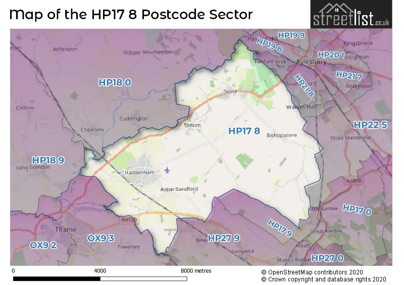
The HP17 8 Postcode shares a border with OX9 3 (THAME, Towersey), HP27 9 (PRINCES RISBOROUGH, Longwick, Bledlow), HP18 0 (AYLESBURY, Waddesdon, Grendon Underwood), HP18 9 (Long Crendon, Brill, Oakley), HP19 7 (AYLESBURY), HP19 8 (AYLESBURY, Rabans Lane Industrial Area, Gatehouse Industrial Area), HP17 9 (Great Kimble, Meadle, Little Meadle), HP21 8 (AYLESBURY), HP21 9 (AYLESBURY) and HP22 5 (Aston Clinton, Weston Turville, Stoke Mandeville).
The sector is within the post town of AYLESBURY.
HP17 8 is a postcode sector within the HP17 postcode district which is within the HP Hemel Hempstead postcode area.
The Royal Mail delivery office for the HP17 8 postal sector is the Aylesbury Vale Postal Delivery Office.
The area of the HP17 8 postcode sector is 20.96 square miles which is 54.28 square kilometres or 13,412.16 square acres.
Waterways within the HP17 8 postcode sector include the Thame.

Map of the HP17 8 Postcode Sector
Explore the HP17 8 postcode sector by using our free interactive map.
| H | P | 1 | 7 | - | 8 | X | X |
| H | P | 1 | 7 | Space | 8 | Letter | Letter |
Official List of Streets
Haddenham (124 Streets)
Stone (35 Streets)
Dinton (12 Streets)
Ford (4 Streets)
Bishopstone (4 Streets)
Kingsey (2 Streets)
Upton (3 Streets)
Great Kimble (1 Streets)
Little Kimble (1 Streets)
Unofficial Streets or Alternative Spellings
AYLESBURY
ANDREWS WAY COLDHARBOUR WAY OXFORD ROAD BISHOPSTONE BURGESS LANE DOLLICOT GREEN LANE HADDENHAM BMX BIKE TRACK LIME AVENUA LOWER FARM GATE LOWER HARTWELL MILLERS WAY MILWAY FURLONG PEBBLE WAY PORTWAY ROUND AYLESBURY WALK ROUNDHILL COURT RUN FURROW SKITTLES GREEN SNAKEMOOR NATURE WALK STONE CROFT STRATFORD WAY THE AYLESBURY RING THE WYCHERT WAY WATER ROAD WESTLINGTON LANE WHITECROSS ROAD WILLOUGHBY ROADDinton
CUDDINGTON ROADCuddington
DADBROOKTHAME
AYLESBURY ROADBledlow
LOWER ICKNIELD WAYLongwick
THAME ROADSchools and Places of Education Within the HP17 8 Postcode Sector
Haddenham Community Infant School
Community school
Woodways, Aylesbury, Buckinghamshire, HP17 8DS
Head: Mrs Lucy McNeil
Ofsted Rating: Good
Inspection: 2023-01-11 (498 days ago)
Website: Visit Haddenham Community Infant School Website
Phone: 01844291207
Number of Pupils: 91
Haddenham Community Junior School
Community school
Woodways, Aylesbury, Buckinghamshire, HP17 8DS
Head: Mr Andy Leach
Ofsted Rating: Good
Inspection: 2018-09-13 (2079 days ago)
Website: Visit Haddenham Community Junior School Website
Phone: 01844291829
Number of Pupils: 368
Haddenham St Mary's Church of England School
Voluntary controlled school
Aston Road, Aylesbury, Buckinghamshire, HP17 8AF
Head: Mrs Karen Collett
Ofsted Rating: Good
Inspection: 2021-09-15 (981 days ago)
Website: Visit Haddenham St Mary's Church of England School Website
Phone: 01844291455
Number of Pupils: 180
Stone Church of England Combined School
Voluntary controlled school
Oxford Road, Aylesbury, Buckinghamshire, HP17 8PD
Head: Mrs Sarah Hale Mrs Bethan Jones
Ofsted Rating: Good
Inspection: 2019-05-09 (1841 days ago)
Website: Visit Stone Church of England Combined School Website
Phone: 01296748340
Number of Pupils: 209
House Prices in the HP17 8 Postcode Sector
| Type of Property | 2018 Average | 2018 Sales | 2017 Average | 2017 Sales | 2016 Average | 2016 Sales | 2015 Average | 2015 Sales |
|---|---|---|---|---|---|---|---|---|
| Detached | £601,670 | 101 | £666,437 | 67 | £580,904 | 70 | £539,126 | 93 |
| Semi-Detached | £460,051 | 47 | £409,089 | 22 | £403,895 | 48 | £433,153 | 33 |
| Terraced | £359,120 | 23 | £389,881 | 26 | £327,642 | 30 | £285,103 | 17 |
| Flats | £201,500 | 7 | £199,361 | 9 | £186,625 | 8 | £162,871 | 11 |
Important Postcodes HP17 8 in the Postcode Sector
HP17 8AF is the postcode for Haddenham St. Marys CE School, Aston Road, and Haddenham St Marys C of E School, Aston Road
HP17 8DS is the postcode for Haddenham Junior School, Woodways, Haddenham, Haddenham Junior School, Woodways, Haddenham Community Infant School, Woodways, and HALL & NURSERY, Haddenham Community Infant School, Woodways
HP17 8JX is the postcode for Haddenham Health Centre, Stanbridge Road
HP17 8PD is the postcode for Stone C of E Primary School, Oxford Road, Stone, and Stone C of E Primary School, Oxford Road
HP17 8UZ is the postcode for Dinton C of E First School, School Lane
| The HP17 8 Sector is within these Local Authorities |
|
|---|---|
| The HP17 8 Sector is within these Counties |
|
| The HP17 8 Sector is within these Water Company Areas |
|