The HP19 0 postcode sector is within the county of Buckinghamshire.
Did you know? According to the 2021 Census, the HP19 0 postcode sector is home to a bustling 2,255 residents!
Given that each sector allows for 400 unique postcode combinations. Letters C, I, K, M, O and V are not allowed in the last two letters of a postcode. With 68 postcodes already in use, this leaves 332 units available.
The HP19 0 postal code covers the settlement of AYLESBURY.
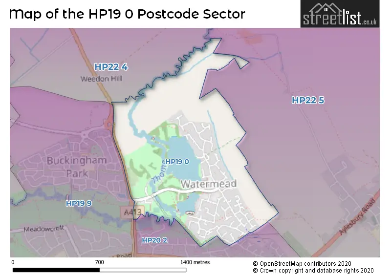
The HP19 0 Postcode shares a border with HP19 9 (AYLESBURY), HP20 2 (AYLESBURY), HP22 4 (Quainton, Wingrave, Whitchurch) and HP22 5 (Aston Clinton, Weston Turville, Stoke Mandeville).
The sector is within the post town of AYLESBURY.
HP19 0 is a postcode sector within the HP19 postcode district which is within the HP Hemel Hempstead postcode area.
The Royal Mail delivery office for the HP19 0 postal sector is the Aylesbury Delivery Office.
The area of the HP19 0 postcode sector is 0.49 square miles which is 1.27 square kilometres or 314.14 square acres.
Waterways within the HP19 0 postcode sector include the Thame.

Map of the HP19 0 Postcode Sector
Explore the HP19 0 postcode sector by using our free interactive map.
| H | P | 1 | 9 | - | 0 | X | X |
| H | P | 1 | 9 | Space | 0 | Letter | Letter |
Official List of Streets
AYLESBURY (57 Streets)
Unofficial Streets or Alternative Spellings
House Prices in the HP19 0 Postcode Sector
| Type of Property | 2018 Average | 2018 Sales | 2017 Average | 2017 Sales | 2016 Average | 2016 Sales | 2015 Average | 2015 Sales |
|---|---|---|---|---|---|---|---|---|
| Detached | £388,711 | 14 | £507,444 | 9 | £449,263 | 19 | £441,834 | 22 |
| Semi-Detached | £274,625 | 8 | £326,356 | 9 | £304,505 | 11 | £260,681 | 13 |
| Terraced | £293,467 | 15 | £280,948 | 20 | £260,796 | 23 | £252,198 | 27 |
| Flats | £196,188 | 8 | £190,586 | 11 | £176,820 | 15 | £153,100 | 19 |
| The HP19 0 Sector is within these Local Authorities |
|
|---|---|
| The HP19 0 Sector is within these Counties |
|
| The HP19 0 Sector is within these Water Company Areas |
|