The HP2 4 postcode sector is within the county of Hertfordshire.
Did you know? According to the 2021 Census, the HP2 4 postcode sector is home to a bustling 12,335 residents!
Given that each sector allows for 400 unique postcode combinations. Letters C, I, K, M, O and V are not allowed in the last two letters of a postcode. With 278 postcodes already in use, this leaves 122 units available.
The largest settlements in the HP2 4 postal code are HEMEL HEMPSTEAD and Paradise Industrial Estate.
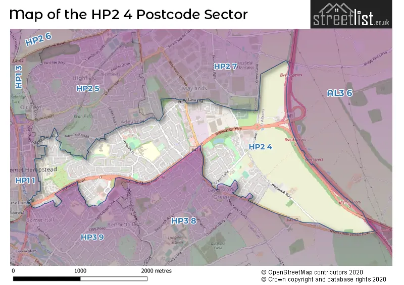
The HP2 4 Postcode shares a border with AL2 3 (BRICKET WOOD, CHISWELL GREEN, ST ALBANS), AL3 6 (ST. ALBANS, Childwickbury, Gorhambury), HP2 5 (HEMEL HEMPSTEAD), HP1 1 (HEMEL HEMPSTEAD), HP2 7 (HEMEL HEMPSTEAD, Hemel Hempstead Industrial Estate), HP3 8 (HEMEL HEMPSTEAD, NASH MILLS, Pimlico) and HP3 9 (HEMEL HEMPSTEAD, Nash Mills Wharf, APSLEY).
The sector is within the post town of HEMEL HEMPSTEAD.
HP2 4 is a postcode sector within the HP2 postcode district which is within the HP Hemel Hempstead postcode area.
The Royal Mail delivery office for the HP2 4 postal sector is the Hemel Hempstead Delivery Office.
The area of the HP2 4 postcode sector is 1.90 square miles which is 4.93 square kilometres or 1,217.74 square acres.
The HP2 4 postcode sector is crossed by the A414 Major A road.
The HP2 4 postcode sector is crossed by the M1 motorway.

Map of the HP2 4 Postcode Sector
Explore the HP2 4 postcode sector by using our free interactive map.
| H | P | 2 | - | 4 | X | X |
| H | P | 2 | Space | 4 | Letter | Letter |
Official List of Streets
HEMEL HEMPSTEAD (137 Streets)
Hemel Hempstead Industrial Estate (1 Streets)
Maylands Gateway (1 Streets)
Schools and Places of Education Within the HP2 4 Postcode Sector
Broadfield Academy
Academy converter
Windmill Road, Hemel Hempstead, Hertfordshire, HP2 4BX
Head: Mrs Rebecca Baggaley
Ofsted Rating: Good
Inspection: 2022-05-18 (740 days ago)
Website: Visit Broadfield Academy Website
Phone: 01442262103
Number of Pupils: 395
Dacorum Education Support Centre
Pupil referral unit
30 Tenzing Road, Hemel Hempstead, Hertfordshire, HP2 4HS
Head: Ms Sara Lalis
Ofsted Rating: Outstanding
Inspection: 2023-05-25 (368 days ago)
Website: Visit Dacorum Education Support Centre Website
Phone: 01442247476
Number of Pupils: 5
Leverstock Green Church of England Primary School
Voluntary controlled school
Green Lane, Hemel Hempstead, Hertfordshire, HP2 4SA
Head: Mrs Victoria Burgess
Ofsted Rating: Good
Inspection: 2018-07-11 (2147 days ago)
Website: Visit Leverstock Green Church of England Primary School Website
Phone: 01442406520
Number of Pupils: 234
The Adeyfield Academy
Academy sponsor led
Longlands, Hemel Hempstead, Hertfordshire, HP2 4DE
Head: Miss Dawn Mason
Ofsted Rating: Good
Inspection: 2023-01-11 (502 days ago)
Website: Visit The Adeyfield Academy Website
Phone: 01442406020
Number of Pupils: 709
House Prices in the HP2 4 Postcode Sector
| Type of Property | 2018 Average | 2018 Sales | 2017 Average | 2017 Sales | 2016 Average | 2016 Sales | 2015 Average | 2015 Sales |
|---|---|---|---|---|---|---|---|---|
| Detached | £621,193 | 23 | £609,500 | 30 | £613,798 | 20 | £493,831 | 20 |
| Semi-Detached | £409,300 | 20 | £426,333 | 21 | £420,435 | 31 | £331,128 | 23 |
| Terraced | £344,206 | 70 | £348,928 | 49 | £327,291 | 63 | £294,233 | 64 |
| Flats | £220,677 | 72 | £224,065 | 62 | £215,898 | 59 | £188,139 | 60 |
Important Postcodes HP2 4 in the Postcode Sector
HP2 4AB is the postcode for High Trees, Hillfield Road
HP2 4AD is the postcode for X RAY WING, Hemel Hempstead General Hospital, MAIN WING, West Hertfordshire Hospitals NHS Trust, Hemel Hempstead General Hospital, VERULAM WING, West Hertfordshire Hospitals NHS Trust, Hemel Hempstead General Hospital, JUBILEE WING, Hemel Hempstead General Hospital, MAIN WING, Hemel Hempstead General Hospital, West Hertfordshire Hospitals NHS Trust, Hemel Hempstead General Hospital, MARNHAM WING, West Hertfordshire Hospitals NHS Trust, Hemel Hempstead General Hospital, X RAY WING, West Hertfordshire Hospitals NHS Trust, Hemel Hempstead General Hospital, JUBILEE WING, West Hertfordshire Hospitals NHS Trust, Hemel Hempstead General Hospital, QUEEN ELIZABETH WING, West Hertfordshire Hospitals NHS Trust, Hemel Hempstead General Hospital, VERULAM WING, Hemel Hempstead General Hospital, and QUEEN ELIZABETH WING, Hemel Hempstead General Hospital
HP2 4BX is the postcode for Broadfield Academy, Windmill Road, and Broadfield Primary School, Windmill Road
HP2 4DE is the postcode for MAIN BLOCK, The Adeyfield Academy, Longlands, and Adeyfield School, Longlands
HP2 4EX is the postcode for Mountbatten Lodge, Old Crabtree Lane
HP2 4HS is the postcode for Hertfordshire County Council, Greenhill Site, Tenzing Road
HP2 4JS is the postcode for Jarman Park Athletics Track, Jarman Way
HP2 4JW is the postcode for The Jarman Centre, Old Crabtree Lane, and Jarman Day Centre, Old Crabtree Lane
HP2 4SA is the postcode for LEVERSTOCK CHURCH OF ENGLAND SCHOOL, GREEN LANE, HEMEL HEMPSTEAD, Leverstock Green C of E Primary School, Green Lane, NURSERY BLOCK, Leverstock Green Church of England Primary School, Green Lane, Leverstock Green Church of England Primary School, Green Lane, and MAIN BLOCK, Leverstock Green Church of England Primary School, Green Lane
HP2 4XN is the postcode for Department for Communities and Local Government, Hempstead House
HP2 4XW is the postcode for Hempstead House, Selden Hill
| The HP2 4 Sector is within these Local Authorities |
|
|---|---|
| The HP2 4 Sector is within these Counties |
|
| The HP2 4 Sector is within these Water Company Areas |
|