The HP2 5 postcode sector is within the county of Hertfordshire.
Did you know? According to the 2021 Census, the HP2 5 postcode sector is home to a bustling 13,730 residents!
Given that each sector allows for 400 unique postcode combinations. Letters C, I, K, M, O and V are not allowed in the last two letters of a postcode. With 304 postcodes already in use, this leaves 96 units available.
The HP2 5 postal code covers the settlement of HEMEL HEMPSTEAD.
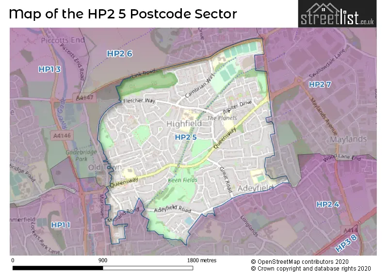
The HP2 5 Postcode shares a border with HP1 3 (HEMEL HEMPSTEAD, Great Gaddesden, Water End), HP2 4 (HEMEL HEMPSTEAD, Paradise Industrial Estate), HP2 6 (HEMEL HEMPSTEAD, Gaddesden Row, Bridens Camp), HP1 1 (HEMEL HEMPSTEAD) and HP2 7 (HEMEL HEMPSTEAD, Hemel Hempstead Industrial Estate).
The sector is within the post town of HEMEL HEMPSTEAD.
HP2 5 is a postcode sector within the HP2 postcode district which is within the HP Hemel Hempstead postcode area.
The Royal Mail delivery office for the HP2 5 postal sector is the Hemel Hempstead Delivery Office.
The area of the HP2 5 postcode sector is 0.96 square miles which is 2.50 square kilometres or 617.32 square acres.

Map of the HP2 5 Postcode Sector
Explore the HP2 5 postcode sector by using our free interactive map.
| H | P | 2 | - | 5 | X | X |
| H | P | 2 | Space | 5 | Letter | Letter |
Official List of Streets
HEMEL HEMPSTEAD (155 Streets)
Schools and Places of Education Within the HP2 5 Postcode Sector
George Street Primary School
Community school
George Street, Hemel Hempstead, Hertfordshire, HP2 5HJ
Head: Mrs Angela Hughes
Ofsted Rating: Good
Inspection: 2021-12-01 (908 days ago)
Website: Visit George Street Primary School Website
Phone: 01442255638
Number of Pupils: 232
Hammond Academy
Academy converter
Cambrian Way, Hemel Hempstead, Hertfordshire, HP2 5TD
Head: Mrs Kerry Graham
Ofsted Rating: Good
Inspection: 2023-06-21 (341 days ago)
Website: Visit Hammond Academy Website
Phone: 01442404020
Number of Pupils: 384
Hobletts Manor Infants' School
Community school
Adeyfield Road, Hemel Hempstead, Hertfordshire, HP2 5JS
Head: Mrs Susan Dyer
Ofsted Rating: Good
Inspection: 2023-06-21 (341 days ago)
Website: Visit Hobletts Manor Infants' School Website
Phone: 01442213854
Number of Pupils: 217
Hobletts Manor Junior School
Community school
Adeyfield Road, Hemel Hempstead, Hertfordshire, HP2 5JS
Head: Mrs Sally Short
Ofsted Rating: Good
Inspection: 2023-03-14 (440 days ago)
Website: Visit Hobletts Manor Junior School Website
Phone: 01442251805
Number of Pupils: 225
Jupiter Primary School
Free schools
Jupiter Drive, Hemel Hempstead, Hertfordshire, HP2 5NT
Head: Mrs Karen Armstrong
Ofsted Rating: Good
Inspection: 2022-09-28 (607 days ago)
Website: Visit Jupiter Primary School Website
Phone: 01442217188
Number of Pupils: 385
Yewtree Primary School
Community school
Fletcher Way, Hemel Hempstead, Hertfordshire, HP2 5QR
Head: Mrs Karen Yilmaz
Ofsted Rating: Good
Inspection: 2022-03-23 (796 days ago)
Website: Visit Yewtree Primary School Website
Phone: 01442424920
Number of Pupils: 361
House Prices in the HP2 5 Postcode Sector
| Type of Property | 2018 Average | 2018 Sales | 2017 Average | 2017 Sales | 2016 Average | 2016 Sales | 2015 Average | 2015 Sales |
|---|---|---|---|---|---|---|---|---|
| Detached | £485,455 | 11 | £505,409 | 13 | £462,857 | 7 | £501,846 | 13 |
| Semi-Detached | £407,147 | 30 | £398,520 | 25 | £365,926 | 35 | £333,726 | 37 |
| Terraced | £314,006 | 86 | £316,073 | 82 | £308,080 | 80 | £256,084 | 89 |
| Flats | £209,227 | 55 | £219,926 | 68 | £216,204 | 66 | £185,265 | 71 |
Important Postcodes HP2 5 in the Postcode Sector
HP2 5BL is the postcode for Fernville Surgery, Midland Road
HP2 5HA is the postcode for Hertfordshire Fire & Rescue Service, Ambulance & Fire Station, Queensway, and Hertfordshire Fire And Rescue Service, Queensway
HP2 5HJ is the postcode for GEORGE STREET PRIMARY SCHOOL, GEORGE STREET, HEMEL HEMPSTEAD, and George Street Primary School, George Street
HP2 5JS is the postcode for Hobletts Manor Infants & Nursery School, Adeyfield Road, and Hobletts Manor Junior School, Adeyfield Road
HP2 5NT is the postcode for Jupiter Community Free School, Jupiter Drive, and Jupiter Drive Jmi School, Jupiter Drive
HP2 5QR is the postcode for INFANT BLOCK, Yewtree Primary School, Fletcher Way, Bellgate Primary School, Fletcher Way, JUNIOR BLOCK, Yewtree Primary School, Fletcher Way, and Yewtree Primary School, Fletcher Way
HP2 5TD is the postcode for Hammond Primary School, Cambrian Way, HAMMOND ACADEMY, CAMBRIAN WAY, HEMEL HEMPSTEAD, THE DEAN WING, The Hammond Academy, Cambrian Way, and The Hammond Academy, Cambrian Way
HP2 5XY is the postcode for St. Pauls, Slippers Hill
| The HP2 5 Sector is within these Local Authorities |
|
|---|---|
| The HP2 5 Sector is within these Counties |
|
| The HP2 5 Sector is within these Water Company Areas |
|