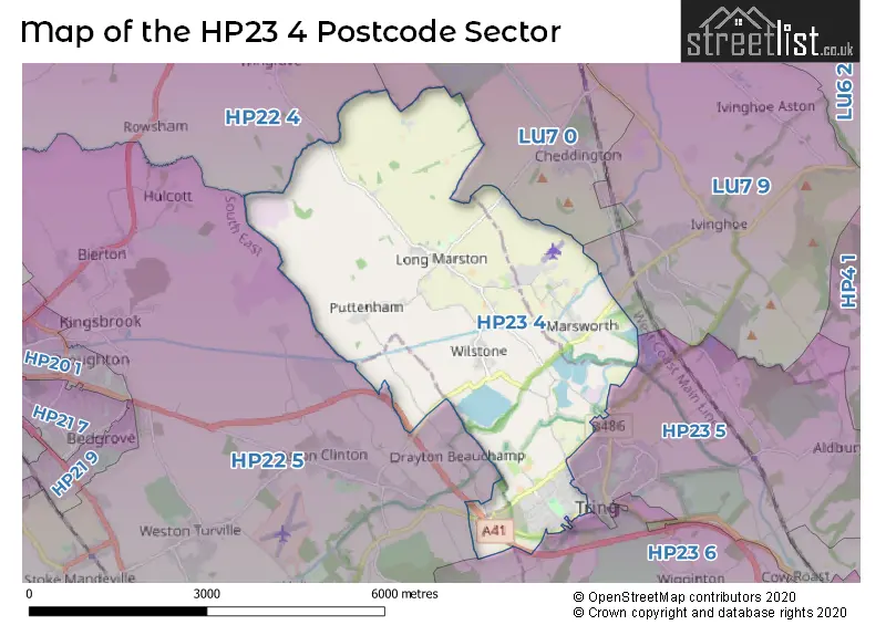
The HP23 4 postcode sector stands on the Buckinghamshire and Hertfordshire border.
Did you know? According to the 2021 Census, the HP23 4 postcode sector is home to a bustling 6,497 residents!
Given that each sector allows for 400 unique postcode combinations. Letters C, I, K, M, O and V are not allowed in the last two letters of a postcode. With 185 postcodes already in use, this leaves 215 units available.
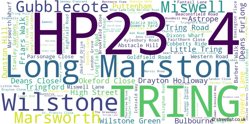
The largest settlement in the HP23 4 postal code is TRING followed by Long Marston, and Marsworth.
The HP23 4 Postcode shares a border with HP23 5 (TRING, Aldbury, Cow Roast), HP23 6 (TRING, Wigginton, Buckland Common), LU7 0 (Wing, Stewkley, Cheddington), HP22 4 (Quainton, Wingrave, Whitchurch), HP22 5 (Aston Clinton, Weston Turville, Stoke Mandeville) and LU7 9 (Pitstone, LEIGHTON BUZZARD, Hockliffe).
The sector is within the post town of TRING.
HP23 4 is a postcode sector within the HP2 postcode district which is within the HP Hemel Hempstead postcode area.
The Royal Mail delivery office for the HP23 4 postal sector is the Hemel Hempstead Delivery Office.
The area of the HP23 4 postcode sector is 10.12 square miles which is 26.22 square kilometres or 6,478.58 square acres.
Waterways within the HP23 4 postcode sector include the Grand Union Canal - Aylesbury Arm, Grand Union Canal - Wendover Arm, Grand Union Canal, Thistle Brook.

Map of the HP23 4 Postcode Sector
Explore the HP23 4 postcode sector by using our free interactive map.
| H | P | 2 | 3 | - | 4 | X | X |
| H | P | 2 | 3 | Space | 4 | Letter | Letter |
Official List of Streets
TRING (63 Streets)
Long Marston (9 Streets)
Wilstone (13 Streets)
Marsworth (15 Streets)
Puttenham (2 Streets)
Drayton Holloway (1 Streets)
Gubblecote (3 Streets)
Wilstone Green (1 Streets)
Tringford (2 Streets)
Weather Forecast for HP23 4
Press Button to Show Forecast for Tring
| Time Period | Icon | Description | Temperature | Rain Probability | Wind |
|---|---|---|---|---|---|
| 18:00 to 21:00 | Partly cloudy (day) | 14.0°C (feels like 13.0°C) | 4.00% | WSW 7 mph | |
| 21:00 to 00:00 | Clear night | 11.0°C (feels like 10.0°C) | 1.00% | SSW 9 mph |
Press Button to Show Forecast for Tring
| Time Period | Icon | Description | Temperature | Rain Probability | Wind |
|---|---|---|---|---|---|
| 00:00 to 03:00 | Cloudy | 10.0°C (feels like 8.0°C) | 6.00% | SSW 9 mph | |
| 03:00 to 06:00 | Overcast | 10.0°C (feels like 9.0°C) | 12.00% | S 9 mph | |
| 06:00 to 09:00 | Overcast | 12.0°C (feels like 10.0°C) | 14.00% | S 9 mph | |
| 09:00 to 12:00 | Light rain | 13.0°C (feels like 11.0°C) | 62.00% | S 11 mph | |
| 12:00 to 15:00 | Heavy rain | 15.0°C (feels like 13.0°C) | 80.00% | SSW 11 mph | |
| 15:00 to 18:00 | Light rain shower (day) | 16.0°C (feels like 13.0°C) | 46.00% | SW 13 mph | |
| 18:00 to 21:00 | Light rain shower (day) | 16.0°C (feels like 13.0°C) | 43.00% | SW 13 mph | |
| 21:00 to 00:00 | Light rain shower (night) | 14.0°C (feels like 12.0°C) | 44.00% | SW 13 mph |
Press Button to Show Forecast for Tring
| Time Period | Icon | Description | Temperature | Rain Probability | Wind |
|---|---|---|---|---|---|
| 00:00 to 03:00 | Cloudy | 12.0°C (feels like 10.0°C) | 8.00% | WSW 13 mph | |
| 03:00 to 06:00 | Cloudy | 12.0°C (feels like 9.0°C) | 11.00% | WSW 13 mph | |
| 06:00 to 09:00 | Cloudy | 12.0°C (feels like 10.0°C) | 7.00% | WSW 11 mph | |
| 09:00 to 12:00 | Partly cloudy (day) | 14.0°C (feels like 12.0°C) | 17.00% | W 11 mph | |
| 12:00 to 15:00 | Light rain shower (day) | 16.0°C (feels like 14.0°C) | 31.00% | W 13 mph | |
| 15:00 to 18:00 | Light rain shower (day) | 17.0°C (feels like 14.0°C) | 31.00% | WNW 11 mph | |
| 18:00 to 21:00 | Partly cloudy (day) | 16.0°C (feels like 14.0°C) | 10.00% | WNW 9 mph | |
| 21:00 to 00:00 | Clear night | 13.0°C (feels like 11.0°C) | 1.00% | WNW 7 mph |
Press Button to Show Forecast for Tring
| Time Period | Icon | Description | Temperature | Rain Probability | Wind |
|---|---|---|---|---|---|
| 00:00 to 03:00 | Clear night | 11.0°C (feels like 9.0°C) | 0.00% | WNW 9 mph | |
| 03:00 to 06:00 | Partly cloudy (night) | 10.0°C (feels like 8.0°C) | 1.00% | WNW 9 mph | |
| 06:00 to 09:00 | Partly cloudy (day) | 11.0°C (feels like 9.0°C) | 2.00% | WNW 11 mph | |
| 09:00 to 12:00 | Cloudy | 13.0°C (feels like 11.0°C) | 10.00% | NW 11 mph | |
| 12:00 to 15:00 | Light rain shower (day) | 15.0°C (feels like 13.0°C) | 33.00% | NW 11 mph | |
| 15:00 to 18:00 | Light rain shower (day) | 16.0°C (feels like 13.0°C) | 37.00% | NNW 11 mph | |
| 18:00 to 21:00 | Light rain shower (day) | 14.0°C (feels like 12.0°C) | 37.00% | NNW 11 mph | |
| 21:00 to 00:00 | Partly cloudy (night) | 12.0°C (feels like 10.0°C) | 4.00% | N 7 mph |
Press Button to Show Forecast for Tring
| Time Period | Icon | Description | Temperature | Rain Probability | Wind |
|---|---|---|---|---|---|
| 00:00 to 03:00 | Clear night | 10.0°C (feels like 9.0°C) | 2.00% | NNW 7 mph | |
| 03:00 to 06:00 | Clear night | 9.0°C (feels like 7.0°C) | 2.00% | NNW 7 mph | |
| 06:00 to 09:00 | Partly cloudy (day) | 10.0°C (feels like 8.0°C) | 3.00% | NNW 9 mph | |
| 09:00 to 12:00 | Cloudy | 13.0°C (feels like 11.0°C) | 9.00% | N 11 mph | |
| 12:00 to 15:00 | Cloudy | 15.0°C (feels like 13.0°C) | 15.00% | N 11 mph | |
| 15:00 to 18:00 | Partly cloudy (day) | 16.0°C (feels like 13.0°C) | 15.00% | N 11 mph | |
| 18:00 to 21:00 | Partly cloudy (day) | 14.0°C (feels like 13.0°C) | 12.00% | N 11 mph | |
| 21:00 to 00:00 | Partly cloudy (night) | 12.0°C (feels like 10.0°C) | 3.00% | NNE 7 mph |
Schools and Places of Education Within the HP23 4 Postcode Sector
Goldfield Infants' and Nursery School
Community school
Christchurch Road, Tring, Hertfordshire, HP23 4EE
Head: Miss Katherine Cooper
Ofsted Rating: Outstanding
Inspection: 2013-09-26 (3896 days ago)
Website: Visit Goldfield Infants' and Nursery School Website
Phone: 01442823551
Number of Pupils: 219
Long Marston VA Church of England Primary School
Voluntary aided school
Station Road, Tring, Hertfordshire, HP23 4QS
Head: Mrs Laura Whateley
Ofsted Rating: Good
Inspection: 2023-03-21 (433 days ago)
Website: Visit Long Marston VA Church of England Primary School Website
Phone: 01296668386
Number of Pupils: 120
Marsworth Church of England Infant School
Voluntary aided school
Vicarage Road, Marsworth, Buckinghamshire, HP23 4LT
Head: Mrs Angela Polatci
Ofsted Rating: Good
Inspection: 2023-04-26 (397 days ago)
Website: Visit Marsworth Church of England Infant School Website
Phone: 01296668440
Number of Pupils: 25
House Prices in the HP23 4 Postcode Sector
| Type of Property | 2018 Average | 2018 Sales | 2017 Average | 2017 Sales | 2016 Average | 2016 Sales | 2015 Average | 2015 Sales |
|---|---|---|---|---|---|---|---|---|
| Detached | £730,000 | 22 | £669,972 | 32 | £703,229 | 33 | £659,448 | 32 |
| Semi-Detached | £586,351 | 32 | £496,985 | 33 | £505,776 | 29 | £497,265 | 34 |
| Terraced | £400,250 | 16 | £372,000 | 17 | £412,563 | 32 | £369,867 | 38 |
| Flats | £256,667 | 6 | £238,900 | 10 | £240,000 | 10 | £203,083 | 18 |
Important Postcodes HP23 4 in the Postcode Sector
HP23 4EE is the postcode for Goldfield Infant & Nursery School, Christchurch Road
HP23 4QS is the postcode for Long Marston VA CE Primary School, Station Road
HP23 4RN is the postcode for Grass Roots Group Plc, Bellis House, Icknield Way Industrial Estate, Icknield Way
HP23 4ZZ is the postcode for Royal Mail, Tring Delivery Office, 46 Western Road
| The HP23 4 Sector is within these Local Authorities |
|
|---|---|
| The HP23 4 Sector is within these Counties |
|
| The HP23 4 Sector is within these Water Company Areas |
|