The HP4 postcode district is a postal district located in the HP Hemel Hempstead postcode area with a population of 24,811 residents according to the 2021 England and Wales Census.
The area of the HP4 postcode district is 23.09 square miles which is 59.79 square kilometres or 14,774.39 acres.
Currently, the HP4 district has about 747 postcode units spread across 3 geographic postcode sectors.
Given that each sector allows for 400 unique postcode combinations, the district has a capacity of 1,200 postcodes. With 747 postcodes already in use, this leaves 453 units available.
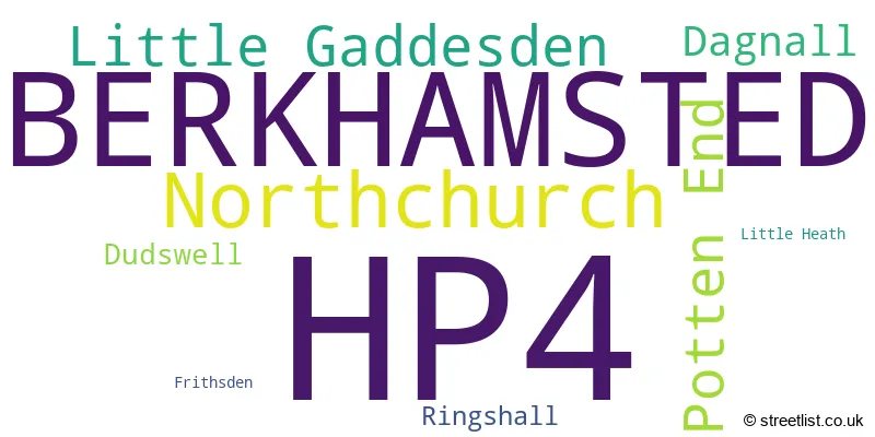
The largest settlement in the HP4 postal code is BERKHAMSTED followed by Northchurch, and Potten End.
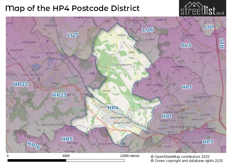
The HP4 Postcode shares a border with LU6 (DUNSTABLE, Eaton Bray, Edlesborough), HP1 (HEMEL HEMPSTEAD, Great Gaddesden, Water End), HP23 (TRING, Wigginton, Long Marston) and HP5 (CHESHAM, Ashley Green, Bellingdon).
In the HP4 postcode district, the primary settlement is Berkhamsted in Hertfordshire, with the highest count. Other significant settlements include Dagnall in Buckinghamshire, Frithsden, Little Gaddesden, Northchurch, Potten End, and Ringshall. The post town for the district is Berkhamsted, also located in Hertfordshire. The county for Berkhamsted is Hertfordshire in England.
For the district HP4, we have data on 4 postcode sectors. Here's a breakdown: The sector HP4 1, covers Berkhamsted and Little Gaddesden in Hertfordshire. The sector HP4 2, covers Berkhamsted and Potten End in Hertfordshire. The sector HP4 3, covers Berkhamsted and Northchurch in Hertfordshire. The sector HP4 9 is non-geographic. It's often designated for PO Boxes, large organisations, or special services.

Map of the HP4 Postcode District
Explore the HP4 postcode district by using our free interactive map.
When it comes to local government, postal geography often disregards political borders. However, for a breakdown in the HP4 District: the district mostly encompasses the Dacorum District (B) (720 postcodes), and finally, the Buckinghamshire area (22 postcodes).
Recent House Sales in HP4
| Date | Price | Address |
|---|---|---|
| 04/10/2023 | £315,000 | Mill Street, Berkhamsted, HP4 2DT |
| 28/09/2023 | £310,000 | Benningfield Gardens, Berkhamsted, HP4 2GX |
| 20/09/2023 | £495,000 | Britwell Drive, Berkhamsted, HP4 2GR |
| 15/09/2023 | £400,000 | Sheldon Way, Berkhamsted, HP4 1FF |
| 13/09/2023 | £745,000 | Archive Mews, Berkhamsted, HP4 3TN |
| 08/09/2023 | £705,000 | Charles Street, Berkhamsted, HP4 3DH |
| 05/09/2023 | £1,280,000 | Upper Hall Park, Berkhamsted, HP4 2NR |
| 05/09/2023 | £700,000 | Darrs Lane, Northchurch, Berkhamsted, HP4 3TT |
| 01/09/2023 | £933,000 | Montague Road, Berkhamsted, HP4 3DS |
| 01/09/2023 | £3,900,000 | Doctors Commons Road, Berkhamsted, HP4 3BY |
Weather Forecast for HP4
Press Button to Show Forecast for Berkhamsted
| Time Period | Icon | Description | Temperature | Rain Probability | Wind |
|---|---|---|---|---|---|
| 03:00 to 06:00 | Clear night | 3.0°C (feels like 0.0°C) | 1.00% | ENE 4 mph | |
| 06:00 to 09:00 | Partly cloudy (day) | 3.0°C (feels like 0.0°C) | 1.00% | NE 7 mph | |
| 09:00 to 12:00 | Partly cloudy (day) | 7.0°C (feels like 4.0°C) | 2.00% | ENE 7 mph | |
| 12:00 to 15:00 | Overcast | 9.0°C (feels like 8.0°C) | 10.00% | ENE 7 mph | |
| 15:00 to 18:00 | Overcast | 10.0°C (feels like 9.0°C) | 14.00% | ENE 4 mph | |
| 18:00 to 21:00 | Cloudy | 9.0°C (feels like 7.0°C) | 10.00% | ENE 7 mph | |
| 21:00 to 00:00 | Cloudy | 6.0°C (feels like 3.0°C) | 12.00% | ENE 7 mph |
Press Button to Show Forecast for Berkhamsted
| Time Period | Icon | Description | Temperature | Rain Probability | Wind |
|---|---|---|---|---|---|
| 00:00 to 03:00 | Cloudy | 4.0°C (feels like 1.0°C) | 12.00% | ENE 7 mph | |
| 03:00 to 06:00 | Cloudy | 3.0°C (feels like 1.0°C) | 14.00% | ENE 7 mph | |
| 06:00 to 09:00 | Cloudy | 4.0°C (feels like 1.0°C) | 19.00% | ENE 9 mph | |
| 09:00 to 12:00 | Overcast | 8.0°C (feels like 5.0°C) | 21.00% | ENE 9 mph | |
| 12:00 to 15:00 | Overcast | 10.0°C (feels like 8.0°C) | 19.00% | E 9 mph | |
| 15:00 to 18:00 | Overcast | 11.0°C (feels like 9.0°C) | 22.00% | ENE 11 mph | |
| 18:00 to 21:00 | Cloudy | 10.0°C (feels like 7.0°C) | 23.00% | ENE 9 mph | |
| 21:00 to 00:00 | Light rain | 8.0°C (feels like 5.0°C) | 55.00% | NE 11 mph |
Press Button to Show Forecast for Berkhamsted
| Time Period | Icon | Description | Temperature | Rain Probability | Wind |
|---|---|---|---|---|---|
| 00:00 to 03:00 | Heavy rain | 7.0°C (feels like 4.0°C) | 74.00% | NE 11 mph | |
| 03:00 to 06:00 | Heavy rain | 7.0°C (feels like 5.0°C) | 77.00% | NE 9 mph | |
| 06:00 to 09:00 | Light rain shower (day) | 8.0°C (feels like 6.0°C) | 43.00% | ESE 9 mph | |
| 09:00 to 12:00 | Light rain | 10.0°C (feels like 7.0°C) | 52.00% | ESE 9 mph | |
| 12:00 to 15:00 | Light rain shower (day) | 11.0°C (feels like 9.0°C) | 47.00% | SE 9 mph | |
| 15:00 to 18:00 | Heavy rain shower (day) | 12.0°C (feels like 10.0°C) | 57.00% | WSW 11 mph | |
| 18:00 to 21:00 | Cloudy | 10.0°C (feels like 8.0°C) | 18.00% | W 11 mph | |
| 21:00 to 00:00 | Partly cloudy (night) | 8.0°C (feels like 6.0°C) | 7.00% | WSW 7 mph |
Where is the HP4 Postcode District?
The postcode district HP4 is located in Berkhamsted, which is a town in the UK. It is situated near several other towns, including Tring to the west, Whelpley Hill to the south, and Hemel Hempstead to the southeast. Additionally, Berkhamsted is approximately 27.09 miles away from the center of London.
The district is within the post town of BERKHAMSTED.
The sector has postcodes within the nation of England.
The HP4 Postcode District is covers the following regions.
- Hertfordshire - Bedfordshire and Hertfordshire - East of England
- Central Bedfordshire - Bedfordshire and Hertfordshire - East of England
| Postcode Sector | Delivery Office |
|---|---|
| HP4 1 | Berkhamsted Delivery Office |
| HP4 2 | Berkhamsted Delivery Office |
| HP4 3 | Berkhamsted Delivery Office |
| H | P | 4 | - | X | X | X |
| H | P | 4 | Space | Numeric | Letter | Letter |
Tourist Attractions within the Postcode Area
We found 1 visitor attractions within the HP4 postcode area
| Ashridge Estate |
|---|
| Other |
| View Ashridge Estate on Google Maps |
Current Monthly Rental Prices
| # Bedrooms | Min Price | Max Price | Avg Price |
|---|---|---|---|
| 1 | £875 | £1,650 | £1,156 |
| 2 | £1,195 | £1,750 | £1,358 |
| 3 | £1,850 | £2,750 | £2,183 |
| 4 | £2,525 | £2,600 | £2,563 |
| 5 | £4,800 | £4,800 | £4,800 |
Current House Prices
| # Bedrooms | Min Price | Max Price | Avg Price |
|---|---|---|---|
| £50,000 | £450,000 | £183,333 | |
| 1 | £175,000 | £385,000 | £282,376 |
| 2 | £130,000 | £1,000,000 | £423,063 |
| 3 | £220,000 | £1,150,000 | £686,737 |
| 4 | £625,000 | £2,750,000 | £1,108,906 |
| 5 | £750,000 | £3,500,000 | £1,625,000 |
| 6 | £999,995 | £3,950,000 | £2,092,856 |
| 7 | £2,500,000 | £4,000,000 | £3,250,000 |
Estate Agents who Operate in the HP4 District
| Logo | Name | Brand Name | Address | Contact Number | Total Properties |
|---|---|---|---|---|---|
 | Berkhamsted | Brown & Merry | 124 High Street, Berkhamsted, HP4 3AT | 01442 504152 | 21 |
 | Berkhamsted | Castles Estate Agents | 148 High Street, Berkhamsted, HP4 3AT | 01442 501600 | 18 |
 | Berkhamsted | Regent Estates | 141-143 High Street, Berkhamsted, HP4 3HH | 01442 504044 | 18 |
 | Berkhamsted | Ashtons | 158 High Street, Berkhamsted, HP4 3AT | 01442 501614 | 17 |
 | Berkhamsted | Nash Partnership | 152 High Street, Berkhamsted, HP4 3AT | 01442 971253 | 16 |
| Type of Property | 2018 Average | 2018 Sales | 2017 Average | 2017 Sales | 2016 Average | 2016 Sales | 2015 Average | 2015 Sales |
|---|---|---|---|---|---|---|---|---|
| Detached | £1,016,906 | 128 | £937,933 | 169 | £933,333 | 136 | £925,123 | 171 |
| Semi-Detached | £602,036 | 97 | £594,783 | 103 | £547,139 | 77 | £538,706 | 98 |
| Terraced | £533,927 | 97 | £525,191 | 113 | £514,657 | 100 | £486,114 | 136 |
| Flats | £398,929 | 80 | £377,048 | 107 | £372,848 | 100 | £321,451 | 161 |