The HP7 postcode district is a postal district located in the HP Hemel Hempstead postcode area with a population of 11,067 residents according to the 2021 England and Wales Census.
The area of the HP7 postcode district is 12.19 square miles which is 31.58 square kilometres or 7,803.86 acres.
Currently, the HP7 district has about 361 postcode units spread across 2 geographic postcode sectors.
Given that each sector allows for 400 unique postcode combinations, the district has a capacity of 800 postcodes. With 361 postcodes already in use, this leaves 439 units available.
The largest settlement in the HP7 postal code is AMERSHAM followed by Coleshill, and Winchmore Hill.
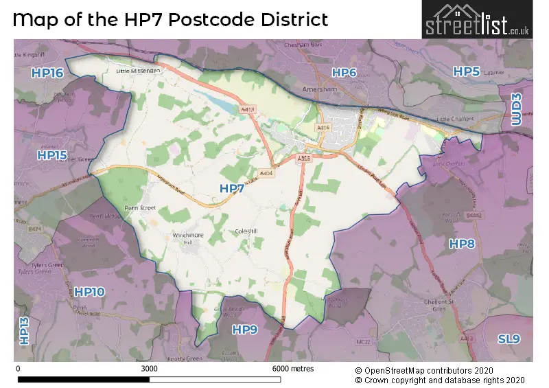
The HP7 Postcode shares a border with HP15 (Hazlemere, Holmer Green, Great Kingshill), HP6 (AMERSHAM, Hyde Heath, LITTLE CHALFONT), HP8 (CHALFONT ST. GILES, CHALFONT ST GILES, LITTLE CHALFONT), HP9 (BEACONSFIELD, Seer Green, Knotty Green) and HP16 (Prestwood, GREAT MISSENDEN, Little Kingshill).
The HP7 postcode district is primarily based in Amersham, Buckinghamshire. Other significant settlements within this district include Beamond End, Coleshill, Little Missenden, Mop End, Penn Street, Winchmore Hill, Woodrow, and Little Chalfont. The most significant post town in this district is Amersham. The county associated with this postcode district is Buckinghamshire.
For the district HP7, we have data on 2 postcode sectors. Here's a breakdown: The sector HP7 0, covers Amersham and Winchmore Hill and Coleshill in Buckinghamshire. The sector HP7 9, covers Amersham in Buckinghamshire.

Map of the HP7 Postcode District
Explore the HP7 postcode district by using our free interactive map.
When it comes to local government, postal geography often disregards political borders. However, for a breakdown in the HP7 District: the district mostly encompasses the Buckinghamshire area with a total of 360 postcodes.
Recent House Sales in HP7
| Date | Price | Address |
|---|---|---|
| 09/10/2023 | £500,000 | Thornhill Close, Amersham, HP7 0EW |
| 26/09/2023 | £575,000 | High Street, Amersham, HP7 0DY |
| 06/09/2023 | £750,000 | Pomeroy Close, Amersham, HP7 9BW |
| 06/09/2023 | £667,500 | Quarrendon Road, Amersham, HP7 9EH |
| 04/09/2023 | £910,000 | White Lion Road, Amersham, HP7 9NQ |
| 01/09/2023 | £720,000 | Little Reeves Avenue, Amersham, HP7 9JB |
| 31/08/2023 | £960,000 | High Street, Amersham, HP7 0DY |
| 30/08/2023 | £1,080,000 | Millshot Drive, Amersham, HP7 9DG |
| 25/08/2023 | £699,950 | Whielden Street, Amersham, HP7 0AP |
| 24/08/2023 | £4,100,000 | Meadowcot Lane, Coleshill, Amersham, HP7 0LL |
Weather Forecast for HP7
Press Button to Show Forecast for Amersham
| Time Period | Icon | Description | Temperature | Rain Probability | Wind |
|---|---|---|---|---|---|
| 00:00 to 03:00 | Cloudy | 4.0°C (feels like 2.0°C) | 4.00% | NE 7 mph | |
| 03:00 to 06:00 | Cloudy | 3.0°C (feels like 0.0°C) | 4.00% | NE 7 mph | |
| 06:00 to 09:00 | Cloudy | 3.0°C (feels like 0.0°C) | 4.00% | NE 7 mph | |
| 09:00 to 12:00 | Partly cloudy (day) | 6.0°C (feels like 4.0°C) | 2.00% | ENE 9 mph | |
| 12:00 to 15:00 | Overcast | 9.0°C (feels like 8.0°C) | 11.00% | ENE 7 mph | |
| 15:00 to 18:00 | Overcast | 10.0°C (feels like 8.0°C) | 14.00% | ENE 4 mph | |
| 18:00 to 21:00 | Cloudy | 9.0°C (feels like 7.0°C) | 12.00% | ENE 7 mph | |
| 21:00 to 00:00 | Cloudy | 6.0°C (feels like 3.0°C) | 12.00% | ENE 7 mph |
Press Button to Show Forecast for Amersham
| Time Period | Icon | Description | Temperature | Rain Probability | Wind |
|---|---|---|---|---|---|
| 00:00 to 03:00 | Cloudy | 4.0°C (feels like 1.0°C) | 13.00% | ENE 7 mph | |
| 03:00 to 06:00 | Cloudy | 3.0°C (feels like 1.0°C) | 15.00% | ENE 7 mph | |
| 06:00 to 09:00 | Cloudy | 4.0°C (feels like 1.0°C) | 23.00% | ENE 9 mph | |
| 09:00 to 12:00 | Overcast | 8.0°C (feels like 5.0°C) | 21.00% | ENE 9 mph | |
| 12:00 to 15:00 | Overcast | 10.0°C (feels like 8.0°C) | 19.00% | E 9 mph | |
| 15:00 to 18:00 | Cloudy | 11.0°C (feels like 9.0°C) | 18.00% | ENE 11 mph | |
| 18:00 to 21:00 | Cloudy | 10.0°C (feels like 7.0°C) | 20.00% | ENE 11 mph | |
| 21:00 to 00:00 | Light rain | 8.0°C (feels like 5.0°C) | 55.00% | NE 13 mph |
Press Button to Show Forecast for Amersham
| Time Period | Icon | Description | Temperature | Rain Probability | Wind |
|---|---|---|---|---|---|
| 00:00 to 03:00 | Heavy rain | 7.0°C (feels like 4.0°C) | 75.00% | NE 11 mph | |
| 03:00 to 06:00 | Heavy rain | 7.0°C (feels like 5.0°C) | 76.00% | NE 9 mph | |
| 06:00 to 09:00 | Light rain | 8.0°C (feels like 5.0°C) | 54.00% | SE 9 mph | |
| 09:00 to 12:00 | Light rain shower (day) | 9.0°C (feels like 7.0°C) | 41.00% | ESE 9 mph | |
| 12:00 to 15:00 | Light rain | 10.0°C (feels like 8.0°C) | 58.00% | SE 9 mph | |
| 15:00 to 18:00 | Light rain shower (day) | 12.0°C (feels like 10.0°C) | 43.00% | WSW 11 mph | |
| 18:00 to 21:00 | Light rain shower (day) | 10.0°C (feels like 7.0°C) | 33.00% | W 11 mph | |
| 21:00 to 00:00 | Cloudy | 8.0°C (feels like 6.0°C) | 7.00% | WSW 9 mph |
Where is the HP7 Postcode District?
The data shows that the postcode district HP7 is located in Amersham, which is a district town. Amersham is situated to the North East of Chalfont St. Giles, approximately 3.14 miles away. It is also close to other nearby towns such as Latimer (4.18 miles), Chesham (4.20 miles), Beaconsfield (4.36 miles), and Chalfont St Peter (4.98 miles). Additionally, the postcode district is approximately 24.08 miles away from the center of London.
The district is within the post town of AMERSHAM.
The sector has postcodes within the nation of England.
The HP7 Postcode District is in the region of within the .
| Postcode Sector | Delivery Office |
|---|---|
| HP7 0 | Amersham Delivery Office |
| HP7 9 | Amersham Delivery Office |
| H | P | 7 | - | X | X | X |
| H | P | 7 | Space | Numeric | Letter | Letter |
Tourist Attractions within the Postcode Area
We found 1 visitor attractions within the HP7 postcode area
| Amersham Museum |
|---|
| Museums & Art Galleries |
| Museum and / or Art Gallery |
| View Amersham Museum on Google Maps |
Current Monthly Rental Prices
| # Bedrooms | Min Price | Max Price | Avg Price |
|---|---|---|---|
| 1 | £1,000 | £1,095 | £1,048 |
| 2 | £1,350 | £1,600 | £1,500 |
| 3 | £1,800 | £2,650 | £2,200 |
| 4 | £2,500 | £2,500 | £2,500 |
| 5 | £2,600 | £2,600 | £2,600 |
Current House Prices
| # Bedrooms | Min Price | Max Price | Avg Price |
|---|---|---|---|
| £15,000 | £850,000 | £184,000 | |
| 1 | £235,000 | £365,000 | £291,250 |
| 2 | £279,950 | £750,000 | £502,892 |
| 3 | £390,000 | £1,000,000 | £756,083 |
| 4 | £600,000 | £2,250,000 | £1,130,526 |
| 5 | £850,000 | £3,250,000 | £2,105,000 |
| 6 | £1,895,000 | £3,950,000 | £3,069,000 |
| 7 | £2,250,000 | £2,250,000 | £2,250,000 |
| 8 | £2,250,000 | £2,250,000 | £2,250,000 |
Estate Agents who Operate in the HP7 District
| Logo | Name | Brand Name | Address | Contact Number | Total Properties |
|---|---|---|---|---|---|
 | Amersham | The Frost Partnership | 61 Hill Avenue, Amersham, HP6 5BX | 01494 341284 | 12 |
 | Amersham | Savills | 55 Hill Avenue, Amersham, HP6 5BX | 01494 341308 | 11 |
 | Amersham | John Nash & Co. | 31 Hill Avenue, Amersham, HP6 5BX | 01494 341307 | 9 |
 | Amersham | Robsons | 19 Hill Avenue Amersham HP6 5BD | 01494 341342 | 7 |
 | Amersham | Hamptons Sales | 3 Sycamore Road, Amersham, HP6 5EQ | 01494 977333 | 5 |
| Type of Property | 2018 Average | 2018 Sales | 2017 Average | 2017 Sales | 2016 Average | 2016 Sales | 2015 Average | 2015 Sales |
|---|---|---|---|---|---|---|---|---|
| Detached | £944,043 | 35 | £832,086 | 54 | £802,072 | 50 | £741,160 | 59 |
| Semi-Detached | £581,715 | 44 | £525,310 | 50 | £567,245 | 43 | £515,022 | 61 |
| Terraced | £483,302 | 24 | £558,917 | 30 | £567,607 | 40 | £510,732 | 45 |
| Flats | £376,052 | 23 | £337,769 | 21 | £333,052 | 48 | £321,141 | 59 |