The IP31 3 postcode sector is within the county of Suffolk.
Did you know? According to the 2021 Census, the IP31 3 postcode sector is home to a bustling 7,297 residents!
Given that each sector allows for 400 unique postcode combinations. Letters C, I, K, M, O and V are not allowed in the last two letters of a postcode. With 258 postcodes already in use, this leaves 142 units available.
The largest settlement in the IP31 3 postal code is Thurston followed by Walsham-le-Willows, and Norton.
The IP31 3 Postcode shares a border with IP30 9 (Elmswell, Woolpit, Rougham), IP31 2 (Stanton, Great Barton, Ixworth), IP14 3 (Haughley, Great Finborough, Onehouse), IP14 4 (Stowupland, Bacton, Old Newton) and IP22 1 (Rickinghall, Palgrave, Wortham).
The sector is within the post town of BURY ST. EDMUNDS.
IP31 3 is a postcode sector within the IP3 postcode district which is within the IP Ipswich postcode area.
The Royal Mail delivery office for the IP31 3 postal sector is the unknown.
The area of the IP31 3 postcode sector is 23.11 square miles which is 59.87 square kilometres or 14,793.55 square acres.
The IP31 3 postcode sector is crossed by the A14 Major A road.

Map of the IP31 3 Postcode Sector
Explore the IP31 3 postcode sector by using our free interactive map.
| I | P | 3 | 1 | - | 3 | X | X |
| I | P | 3 | 1 | Space | 3 | Letter | Letter |
Official List of Streets
Badwell Ash (30 Streets)
Norton (23 Streets)
Walsham-le-Willows (30 Streets)
Thurston (100 Streets)
Langham (1 Streets)
Stowlangtoft (5 Streets)
Great Ashfield (9 Streets)
Hunston (2 Streets)
Unofficial Streets or Alternative Spellings
Finningham
WALSHAM ROADStanton
UPTHORPE ROADElmswell
ASHFIELD ROADTostock
NORTON ROADRickinghall
WEST HALL ROADWattisfield
WALSHAM ROADBadwell Ash
ASH MEADHepworth
SUMNER ROADPakenham
BULL ROAD ORCHARD LANE STOW LANEBeyton
THURSTON ROADGreat Barton
THURSTON ROAD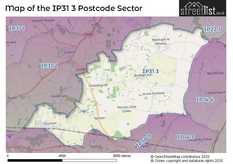
House Prices in the IP31 3 Postcode Sector
| Type of Property | 2018 Average | 2018 Sales | 2017 Average | 2017 Sales | 2016 Average | 2016 Sales | 2015 Average | 2015 Sales |
|---|---|---|---|---|---|---|---|---|
| Detached | £456,029 | 77 | £441,287 | 75 | £419,751 | 82 | £381,291 | 63 |
| Semi-Detached | £258,670 | 28 | £264,455 | 33 | £223,294 | 27 | £211,617 | 38 |
| Terraced | £212,697 | 9 | £213,273 | 22 | £230,787 | 27 | £198,538 | 20 |
| Flats | £195,000 | 2 | £158,333 | 3 | £264,190 | 5 | £189,750 | 4 |
Important Postcodes IP31 3 in the Postcode Sector
IP31 3BD is the postcode for Walsham Primary School, Wattisfield Road, and Walsham le Willows CEVC Primary School, Wattisfield Road, Walsham le Willows
IP31 3LZ is the postcode for Norton VC School, School Close, Block B, Norton CEVC Primary School, School Close, and Main Building, Norton CEVC Primary School, School Close
IP31 3PB is the postcode for SPORTS HALL, Thurston Community College, Norton Road, SIXTH FORM/LIBRARY, Thurston Community College, Norton Road, Block 6 Library, Thurston Community College, Norton Road, and Thurston Community College, Norton Road
IP31 3RY is the postcode for Thurston VC Primary School, School Lane, and Priory Aspire, School Lane, Thurston
| The IP31 3 Sector is within these Local Authorities |
|
|---|---|
| The IP31 3 Sector is within these Counties |
|
| The IP31 3 Sector is within these Water Company Areas |
|