The IP33 2 postcode sector is within the county of Suffolk.
Did you know? According to the 2021 Census, the IP33 2 postcode sector is home to a bustling 8,886 residents!
Given that each sector allows for 400 unique postcode combinations. Letters C, I, K, M, O and V are not allowed in the last two letters of a postcode. With 224 postcodes already in use, this leaves 176 units available.
The IP33 2 postal code covers the settlement of BURY ST. EDMUNDS.
The IP33 2 Postcode shares a border with IP33 3 (BURY ST. EDMUNDS, Westley), IP30 0 (Cockfield, Rattlesden, Great Whelnetham), IP32 7 (BURY ST. EDMUNDS), IP29 5 (Barrow, Horringer, Chevington) and IP33 1 (BURY ST. EDMUNDS).
The sector is within the post town of BURY ST. EDMUNDS.
IP33 2 is a postcode sector within the IP3 postcode district which is within the IP Ipswich postcode area.
The Royal Mail delivery office for the IP33 2 postal sector is the unknown.
The area of the IP33 2 postcode sector is 2.30 square miles which is 5.97 square kilometres or 1,474.74 square acres.
The IP33 2 postcode sector is crossed by the A14 Major A road.
Waterways within the IP33 2 postcode sector include the Lark.

Map of the IP33 2 Postcode Sector
Explore the IP33 2 postcode sector by using our free interactive map.
| I | P | 3 | 3 | - | 2 | X | X |
| I | P | 3 | 3 | Space | 2 | Letter | Letter |
Official List of Streets
BURY ST. EDMUNDS (122 Streets)
Unofficial Streets or Alternative Spellings
BURY ST. EDMUNDS
FLEMYNG ROAD LINNET PLACE PETTICOAT LANE SAXON RISE WESTGATE STREETHorringer
WESTLEY LANE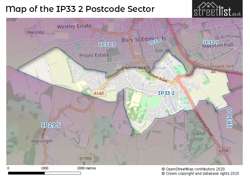
House Prices in the IP33 2 Postcode Sector
| Type of Property | 2018 Average | 2018 Sales | 2017 Average | 2017 Sales | 2016 Average | 2016 Sales | 2015 Average | 2015 Sales |
|---|---|---|---|---|---|---|---|---|
| Detached | £412,437 | 46 | £425,838 | 34 | £392,584 | 53 | £416,725 | 50 |
| Semi-Detached | £274,474 | 39 | £263,842 | 49 | £260,273 | 33 | £244,857 | 42 |
| Terraced | £328,185 | 43 | £267,578 | 40 | £225,043 | 46 | £210,769 | 50 |
| Flats | £203,875 | 22 | £147,955 | 11 | £170,245 | 26 | £208,329 | 35 |
Important Postcodes IP33 2 in the Postcode Sector
IP33 2AA is the postcode for St Edmunds Hospital, St Marys Square
IP33 2AP is the postcode for Suffolk Constabulary, Raingate Street, and Suffolk Constabulary, Police Station, Raingate Street
IP33 2AR is the postcode for Records Office, 77 Raingate Street
IP33 2BD is the postcode for State Veterinary Service, 100 Southgate Street
IP33 2EX is the postcode for Glastonbury Court, Glastonbury Road, and Horringer Court Middle School, Glastonbury Road
IP33 2PD is the postcode for Hardwick Middle School, Mayfield Road, and Riverwalk School, Mayfield Road
IP33 2PW is the postcode for The Childrens Centre, Steward Road, HARDWICK PRIMARY SCHOOL, STEWARD ROAD, BURY ST EDMUNDS, and Hardwick Primary School, Steward Road
IP33 2QZ is the postcode for West Suffolk Hospital, Hardwick Lane, WEST SUFFOLK HOSPITAL MAIN HOSPITAL, West Suffolk Hospital, Hardwick Lane, Main Hospital, West Suffolk Hospital, Hardwick Lane, WEDGWOOD UNIT, WEST SUFFOLK HOSPITAL, HARDWICK LANE, Education Centre, West Suffolk Hospital, Hardwick Lane, WEDGEWOOD UNIT, West Suffolk Hospital, Hardwick Lane, WEST SUFFOLK HOSPITAL EDUCATION CENTRE, West Suffolk Hospital, Hardwick Lane, WEST SUFFOLK HOSPITAL DAY SURGERY TREATMENT UNIT, West Suffolk Hospital, Hardwick Lane, QUINCE HOUSE, West Suffolk Hospital, Hardwick Lane, and Day Surgery Treatment Unit, West Suffolk Hospital, Hardwick Lane
IP33 2RT is the postcode for Suffolk Police, Bury St Edmunds PIC, River Lane, and Police Investigation Centre, River Lane
IP33 2RX is the postcode for Department For Enviroment, Food & Rural Affairs, APHA Veterinary Investigation Centre, Rougham Hill, and Department for Environment Food & Rural Affairs (D E F R A), Rougham Hill
| The IP33 2 Sector is within these Local Authorities |
|
|---|---|
| The IP33 2 Sector is within these Counties |
|
| The IP33 2 Sector is within these Water Company Areas |
|