The IP30 0 postcode sector is within the county of Suffolk.
Did you know? According to the 2021 Census, the IP30 0 postcode sector is home to a bustling 4,674 residents!
Given that each sector allows for 400 unique postcode combinations. Letters C, I, K, M, O and V are not allowed in the last two letters of a postcode. With 224 postcodes already in use, this leaves 176 units available.
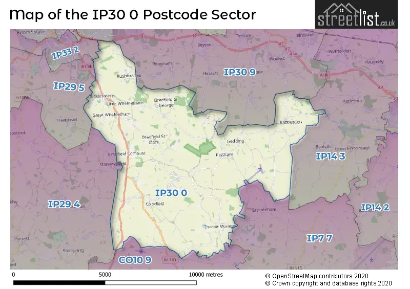
The largest settlement in the IP30 0 postal code is Cockfield followed by Rattlesden, and Great Whelnetham.
The IP30 0 Postcode shares a border with CO10 9 (Long Melford, Lavenham, Stanstead), IP7 7 (Bildeston, Hitcham, Wattisham Airfield), IP33 2 (BURY ST. EDMUNDS), IP30 9 (Elmswell, Woolpit, Rougham), IP32 7 (BURY ST. EDMUNDS), IP14 3 (Haughley, Great Finborough, Onehouse), IP29 4 (Lawshall, Chedburgh, Whepstead) and IP29 5 (Barrow, Horringer, Chevington).
The sector is within the post town of BURY ST. EDMUNDS.
IP30 0 is a postcode sector within the IP30 postcode district which is within the IP Ipswich postcode area.
The Royal Mail delivery office for the IP30 0 postal sector is the Bury St. Edmunds Delivery Office.
The area of the IP30 0 postcode sector is 30.21 square miles which is 78.25 square kilometres or 19,335.64 square acres.
The IP30 0 postcode sector is crossed by the A14 Major A road.
Waterways within the IP30 0 postcode sector include the Lark.

Map of the IP30 0 Postcode Sector
Explore the IP30 0 postcode sector by using our free interactive map.
| I | P | 3 | 0 | - | 0 | X | X |
| I | P | 3 | 0 | Space | 0 | Letter | Letter |
Official List of Streets
Rattlesden (30 Streets)
Cockfield (29 Streets)
Thorpe Morieux (5 Streets)
Bradfield St. Clare (3 Streets)
Bradfield St. George (11 Streets)
Felsham (11 Streets)
Sicklesmere (4 Streets)
Great Whelnetham (10 Streets)
Little Whelnetham (7 Streets)
Gedding (2 Streets)
Bradfield Combust (2 Streets)
Rushbrooke (2 Streets)
Unofficial Streets or Alternative Spellings
Buxhall
BRETTENHAM ROAD BACK ROAD BENTON LANE BLACKSMITH LANE CHAPEL HILL CRIMBOLDS LANE CROWBROOK PLACE DARKINGS LANE EUSTONS GALLOW LANE GEDDING ROAD GIPSY LANE GREEN ROAD HAWKERS LANE HOLLYBUSH LANE LAWSHALL ROAD LINKWOOD ROAD LITTLE WELNETHAM ROAD LOUSE LANE LOWER STREET MANOR ROAD PERRYDOWN LANE POY STREET RATTLESDEN ROAD SHEEPGATE LANE THE DRIVERougham
KINGSHALL STREETBURY ST. EDMUNDS
RUSHBROOKE LANEWeather Forecast for IP30 0
Press Button to Show Forecast for Maypole Green
| Time Period | Icon | Description | Temperature | Rain Probability | Wind |
|---|---|---|---|---|---|
| 21:00 to 00:00 | Overcast | 10.0°C (feels like 8.0°C) | 8.00% | NNE 7 mph |
Press Button to Show Forecast for Maypole Green
| Time Period | Icon | Description | Temperature | Rain Probability | Wind |
|---|---|---|---|---|---|
| 00:00 to 03:00 | Overcast | 9.0°C (feels like 8.0°C) | 8.00% | N 7 mph | |
| 03:00 to 06:00 | Overcast | 8.0°C (feels like 7.0°C) | 9.00% | N 7 mph | |
| 06:00 to 09:00 | Overcast | 8.0°C (feels like 7.0°C) | 10.00% | N 7 mph | |
| 09:00 to 12:00 | Cloudy | 11.0°C (feels like 10.0°C) | 6.00% | N 4 mph | |
| 12:00 to 15:00 | Partly cloudy (day) | 15.0°C (feels like 15.0°C) | 1.00% | NNE 4 mph | |
| 15:00 to 18:00 | Partly cloudy (day) | 17.0°C (feels like 17.0°C) | 0.00% | NNE 4 mph | |
| 18:00 to 21:00 | Partly cloudy (day) | 15.0°C (feels like 14.0°C) | 1.00% | SE 7 mph | |
| 21:00 to 00:00 | Clear night | 10.0°C (feels like 8.0°C) | 1.00% | SSE 7 mph |
Press Button to Show Forecast for Maypole Green
| Time Period | Icon | Description | Temperature | Rain Probability | Wind |
|---|---|---|---|---|---|
| 00:00 to 03:00 | Cloudy | 9.0°C (feels like 7.0°C) | 4.00% | S 7 mph | |
| 03:00 to 06:00 | Cloudy | 9.0°C (feels like 7.0°C) | 5.00% | S 7 mph | |
| 06:00 to 09:00 | Cloudy | 10.0°C (feels like 9.0°C) | 4.00% | SSW 4 mph | |
| 09:00 to 12:00 | Sunny day | 16.0°C (feels like 16.0°C) | 1.00% | SSW 4 mph | |
| 12:00 to 15:00 | Cloudy | 19.0°C (feels like 19.0°C) | 6.00% | SSW 4 mph | |
| 15:00 to 18:00 | Cloudy | 20.0°C (feels like 19.0°C) | 8.00% | SSW 4 mph | |
| 18:00 to 21:00 | Cloudy | 18.0°C (feels like 18.0°C) | 4.00% | SSE 4 mph | |
| 21:00 to 00:00 | Cloudy | 12.0°C (feels like 11.0°C) | 4.00% | SSE 7 mph |
Press Button to Show Forecast for Maypole Green
| Time Period | Icon | Description | Temperature | Rain Probability | Wind |
|---|---|---|---|---|---|
| 00:00 to 03:00 | Cloudy | 10.0°C (feels like 9.0°C) | 4.00% | SSE 4 mph | |
| 03:00 to 06:00 | Cloudy | 9.0°C (feels like 8.0°C) | 4.00% | S 4 mph | |
| 06:00 to 09:00 | Cloudy | 11.0°C (feels like 11.0°C) | 5.00% | SSE 4 mph | |
| 09:00 to 12:00 | Cloudy | 17.0°C (feels like 17.0°C) | 4.00% | SSE 4 mph | |
| 12:00 to 15:00 | Cloudy | 19.0°C (feels like 19.0°C) | 4.00% | SE 4 mph | |
| 15:00 to 18:00 | Cloudy | 20.0°C (feels like 19.0°C) | 5.00% | SE 7 mph | |
| 18:00 to 21:00 | Cloudy | 17.0°C (feels like 16.0°C) | 4.00% | SE 7 mph | |
| 21:00 to 00:00 | Cloudy | 13.0°C (feels like 12.0°C) | 4.00% | SE 4 mph |
Press Button to Show Forecast for Maypole Green
| Time Period | Icon | Description | Temperature | Rain Probability | Wind |
|---|---|---|---|---|---|
| 00:00 to 03:00 | Partly cloudy (night) | 11.0°C (feels like 10.0°C) | 1.00% | SE 4 mph | |
| 03:00 to 06:00 | Clear night | 9.0°C (feels like 8.0°C) | 2.00% | SE 4 mph | |
| 06:00 to 09:00 | Sunny day | 12.0°C (feels like 11.0°C) | 2.00% | SE 4 mph | |
| 09:00 to 12:00 | Sunny day | 17.0°C (feels like 17.0°C) | 1.00% | SE 4 mph | |
| 12:00 to 15:00 | Partly cloudy (day) | 20.0°C (feels like 19.0°C) | 3.00% | SSE 7 mph | |
| 15:00 to 18:00 | Partly cloudy (day) | 21.0°C (feels like 19.0°C) | 4.00% | SSE 7 mph | |
| 18:00 to 21:00 | Sunny day | 18.0°C (feels like 17.0°C) | 1.00% | SE 7 mph | |
| 21:00 to 00:00 | Clear night | 13.0°C (feels like 12.0°C) | 1.00% | SE 7 mph |
Schools and Places of Education Within the IP30 0 Postcode Sector
Great Whelnetham Church of England Primary School
Academy sponsor led
Stanningfield Road, Bury St. Edmunds, , IP30 0UA
Head: Mrs Claire Flatman
Ofsted Rating: Good
Inspection: 2023-10-12 (208 days ago)
Website: Visit Great Whelnetham Church of England Primary School Website
Phone: 01284386203
Number of Pupils: 76
Rattlesden Church of England Primary Academy
Academy converter
School Road, Bury St Edmunds, Suffolk, IP30 0SE
Head: Helen Ballam
Ofsted Rating: Good
Inspection: 2018-10-18 (2028 days ago)
Website: Visit Rattlesden Church of England Primary Academy Website
Phone: 01449736335
Number of Pupils: 120
House Prices in the IP30 0 Postcode Sector
| Type of Property | 2018 Average | 2018 Sales | 2017 Average | 2017 Sales | 2016 Average | 2016 Sales | 2015 Average | 2015 Sales |
|---|---|---|---|---|---|---|---|---|
| Detached | £488,816 | 34 | £518,581 | 31 | £498,519 | 27 | £418,210 | 45 |
| Semi-Detached | £291,294 | 17 | £254,633 | 15 | £257,262 | 13 | £260,000 | 14 |
| Terraced | £219,271 | 12 | £217,300 | 5 | £196,900 | 10 | £203,115 | 17 |
| Flats | £0 | 0 | £0 | 0 | £95,000 | 1 | £209,165 | 3 |
Important Postcodes IP30 0 in the Postcode Sector
IP30 0LA is the postcode for Cockfield Cp School, Church Lane
IP30 0UA is the postcode for Great Whelnetham Primary School, Stanningfield Road
| The IP30 0 Sector is within these Local Authorities |
|
|---|---|
| The IP30 0 Sector is within these Counties |
|
| The IP30 0 Sector is within these Water Company Areas |
|