The IP33 3 postcode sector is within the county of Suffolk.
Did you know? According to the 2021 Census, the IP33 3 postcode sector is home to a bustling 10,313 residents!
Given that each sector allows for 400 unique postcode combinations. Letters C, I, K, M, O and V are not allowed in the last two letters of a postcode. With 285 postcodes already in use, this leaves 115 units available.
The largest settlements in the IP33 3 postal code are BURY ST. EDMUNDS and Westley.
The IP33 3 Postcode shares a border with IP33 2 (BURY ST. EDMUNDS), IP32 6 (BURY ST. EDMUNDS), IP28 6 (Risby, Barton Mills, Fornham All Saints), IP29 5 (Barrow, Horringer, Chevington) and IP33 1 (BURY ST. EDMUNDS).
The sector is within the post town of BURY ST. EDMUNDS.
IP33 3 is a postcode sector within the IP3 postcode district which is within the IP Ipswich postcode area.
The Royal Mail delivery office for the IP33 3 postal sector is the unknown.
The area of the IP33 3 postcode sector is 2.78 square miles which is 7.20 square kilometres or 1,779.56 square acres.
The IP33 3 postcode sector is crossed by the A14 Major A road.

Map of the IP33 3 Postcode Sector
Explore the IP33 3 postcode sector by using our free interactive map.
| I | P | 3 | 3 | - | 3 | X | X |
| I | P | 3 | 3 | Space | 3 | Letter | Letter |
Official List of Streets
BURY ST. EDMUNDS (142 Streets)
Unofficial Streets or Alternative Spellings
BURY ST. EDMUNDS
GUILDHALL STREET HUNTINGFIELD ROAD WESTGATE STREET WOOLHALL STREET BEETONS COTTAGES BULL RUSH CRESCENT BYRD CLOSE CATHEDRAL MEADOW CHALK ROAD (NORTH) CHALK ROAD (SOUTH) CHALLICE ROAD CORNWALLIS COURT CORNWALLIS MEWS DRUMMOND COURT ELSEYS YARD LACY COURT LANGTON ROAD MERCHANTS PLACE MILL ROAD (SOUTH) PARKWAY NORTH PARKWAY SOUTH PLUMPTONS COURT PUDDING LANE SAINT ANDREWS STREET SOUTH SAINT EDMUNDSBURY MEWS ST ANDREWS COURT ST EDMUNDSBURY MEWS ST MARYS COURT THE BEECHES THE MEAD TIDYS COURT WESTBANK PLACE WESTERN WAY (EAST) WESTERN WAY (WEST) WESTLEY INTERCHANGE WESTLEY TO WESTLEY SCHOOLHorringer
WESTLEY LANE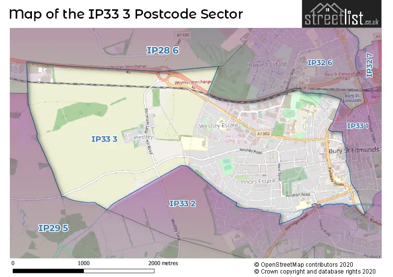
House Prices in the IP33 3 Postcode Sector
| Type of Property | 2018 Average | 2018 Sales | 2017 Average | 2017 Sales | 2016 Average | 2016 Sales | 2015 Average | 2015 Sales |
|---|---|---|---|---|---|---|---|---|
| Detached | £429,586 | 38 | £402,073 | 34 | £400,412 | 43 | £373,960 | 63 |
| Semi-Detached | £316,199 | 51 | £317,884 | 41 | £299,740 | 46 | £272,127 | 43 |
| Terraced | £278,725 | 55 | £270,697 | 67 | £253,185 | 81 | £234,595 | 81 |
| Flats | £163,929 | 14 | £168,024 | 31 | £153,965 | 36 | £161,034 | 25 |
Important Postcodes IP33 3 in the Postcode Sector
IP33 3BA is the postcode for Suffolk Fire & Rescue Service, Parkway
IP33 3BH is the postcode for ART BLOCK, King Edward VI Upper School, Grove Road, King Edward BT Block, King Edward V1 CEVP School, Grove Road, King Edward V1 Main Building, Grove Road, King Edward VI Upper School, Grove Road, King Edward Sports Dome, King Edward V1 CEVP School, Grove Road, King Edward V1 Art Block, King Edward V1 CEVP School, Grove Road, and King Edward Maths Block, King Edward V1 CEVP School, Grove Road
IP33 3BJ is the postcode for St. Edmundsbury CEVA Primary School, Grove Road, St. Edmundsbury CE VA Primary School, Grove Road, St Edmundsbury Ceva Primary School, Grove Road, ST EDMUNDSBURY CEVA PRIMARY SCHOOL, GROVE ROAD, BURY ST EDMUNDS, and St Edmundsbury Church of England Voluntary Aided Primary School, Grove Road
IP33 3FD is the postcode for The Apex, Charter Square, and The Apex, 1-2 Charter Square
IP33 3HG is the postcode for Sextons Manor Community Primary School, Greene Road
IP33 3JB is the postcode for Westley County Middle School, Oliver Road
IP33 3JX is the postcode for Westgate Community Primary School, Brooklands Close, and Westgate Cp School, Brooklands Close
IP33 3JZ is the postcode for Riverwalk School, South Close
IP33 3ND is the postcode for Child Health Centre, Hospital Road, and Child Development Centre, Hospital Road
IP33 3NR is the postcode for F BLOCK, The Local Health Partnership N H S Trust, Hospital Road, G BLOCK, The Local Health Partnership N H S Trust, Hospital Road, and S BLOCK, The Local Health Partnership N H S Trust, Hospital Road
IP33 3PH is the postcode for St. Louis RC Middle School, St. Andrews Street South
IP33 3RL is the postcode for MINDEN HOUSE, West Suffolk College, Out Risbygate, MAIN BUILDING. SUFFOLK - EDMUND HOUSE, West Suffolk College, Out Risbygate, GIBRALTAR HOUSE, West Suffolk College, Out Risbygate, LEONARDO HOUSE, West Suffolk College, Out Risbygate, GATEWAY, West Suffolk College, Out Risbygate, and AUSTRALIA HOUSE, West Suffolk College, Out Risbygate
IP33 3RN is the postcode for The Regiment Secretary, Out Risbygate, Gibraltar Barracks
IP33 3SP is the postcode for The Havebury Housing Partnership, Havebury House, Western Way
IP33 3TB is the postcode for West Suffolk College, STEM Innovation Campus, 73 Western Way
IP33 3TT is the postcode for Bury St. Edmunds Leisure Centre, Beetons Way
IP33 3TU is the postcode for SUITE 3, Dettingen House, Dettingen Way
IP33 3YS is the postcode for St. Edmundsbury Borough Council, and ST EDMUNDSBURY DEPOT, St. Edmundsbury Borough Council
IP33 3YU is the postcode for Abbeygate Sixth Form College, Beetons Way, and West Suffolk House, Western Way
| The IP33 3 Sector is within these Local Authorities |
|
|---|---|
| The IP33 3 Sector is within these Counties |
|
| The IP33 3 Sector is within these Water Company Areas |
|