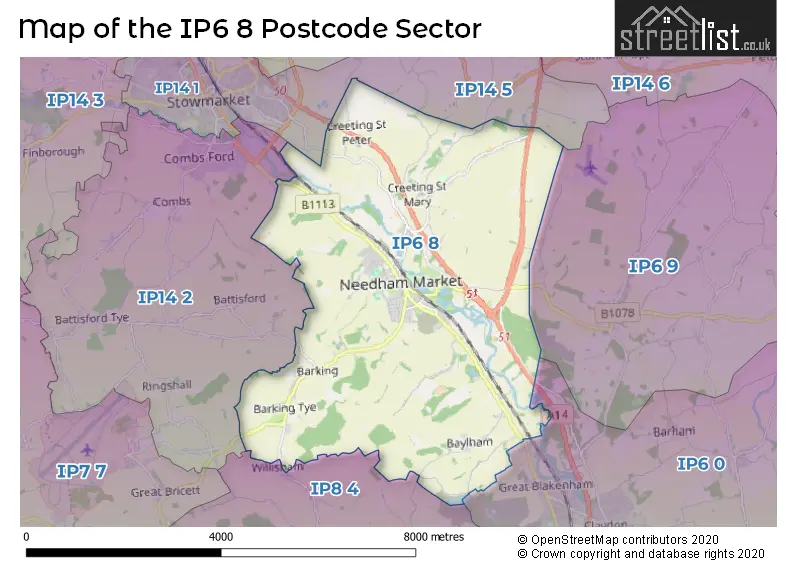
The IP6 8 postcode sector is within the county of Suffolk.
Did you know? According to the 2021 Census, the IP6 8 postcode sector is home to a bustling 6,549 residents!
Given that each sector allows for 400 unique postcode combinations. Letters C, I, K, M, O and V are not allowed in the last two letters of a postcode. With 269 postcodes already in use, this leaves 131 units available.
The largest settlement in the IP6 8 postal code is Needham Market followed by Creeting St. Mary, and Barking.
The IP6 8 Postcode shares a border with IP6 0 (Great Blakenham, Claydon, Barham), IP6 9 (Otley, Witnesham, Coddenham), IP14 2 (STOWMARKET, Combs, Battisford), IP14 5 (STOWMARKET, Mendlesham, Wetheringsett) and IP8 4 (Bramford, Lower Somersham, Offton).
The sector is within the post town of IPSWICH.
IP6 8 is a postcode sector within the IP6 postcode district which is within the IP Ipswich postcode area.
The Royal Mail delivery office for the IP6 8 postal sector is the Needham Market Scale Payment Delivery Office and Ipswich Delivery Office.
The area of the IP6 8 postcode sector is 15.22 square miles which is 39.42 square kilometres or 9,741.73 square acres.
The IP6 8 postcode sector is crossed by the A14 Major A road.
Waterways within the IP6 8 postcode sector include the Gipping, River Gipping.


Map of the IP6 8 Postcode Sector
Explore the IP6 8 postcode sector by using our free interactive map.
| I | P | 6 | - | 8 | X | X |
| I | P | 6 | Space | 8 | Letter | Letter |
Official List of Streets
Needham Market (85 Streets)
Creeting St. Mary (18 Streets)
Badley (1 Streets)
Barking (9 Streets)
Baylham (11 Streets)
Creeting St. Peter (5 Streets)
Coddenham (1 Streets)
Unofficial Streets or Alternative Spellings
Coddenham
NEEDHAM ROADCreeting St. Mary
JORDAN CLOSENeedham Market
MILL LANEGreat Blakenham
STOWMARKET ROADBarham
NORWICH ROADSchools and Places of Education Within the IP6 8 Postcode Sector
Creeting St Mary Church of England Voluntary Aided Primary School
Voluntary aided school
All Saints Road, Ipswich, Suffolk, IP6 8NF
Head: Mrs Christine Friar
Ofsted Rating: Good
Inspection: 2022-02-09 (851 days ago)
Website: Visit Creeting St Mary Church of England Voluntary Aided Primary School Website
Phone: 01449720312
Number of Pupils: 98

House Prices in the IP6 8 Postcode Sector
| Type of Property | 2018 Average | 2018 Sales | 2017 Average | 2017 Sales | 2016 Average | 2016 Sales | 2015 Average | 2015 Sales |
|---|---|---|---|---|---|---|---|---|
| Detached | £384,351 | 44 | £363,588 | 34 | £330,988 | 27 | £289,438 | 24 |
| Semi-Detached | £235,493 | 47 | £217,542 | 42 | £213,909 | 47 | £193,275 | 34 |
| Terraced | £213,209 | 44 | £220,969 | 32 | £203,646 | 29 | £191,597 | 36 |
| Flats | £133,190 | 21 | £120,133 | 15 | £129,488 | 32 | £116,284 | 31 |
Important Postcodes IP6 8 in the Postcode Sector
IP6 8BB is the postcode for Needham Market Middle School, School Street
IP6 8BP is the postcode for Bosmere Cp School, Quinton Road, and Bosmere Cp School, Quinton Road, Needham Market
IP6 8DA is the postcode for Bosmere Community Primary School, Quinton Road
IP6 8DL is the postcode for Mid Suffolk District Council, Council Offices, 131 High Street
IP6 8EZ is the postcode for Needham Market Country Practice, Barking Road
IP6 8NF is the postcode for Creeting St. Mary Primary School, All Saints Road
| The IP6 8 Sector is within these Local Authorities |
|
|---|---|
| The IP6 8 Sector is within these Counties |
|
| The IP6 8 Sector is within these Water Company Areas |
|
Tourist Attractions within the IP6 8 Postcode Area
We found 1 visitor attractions within the IP6 postcode area
| Needham Lake and Nature Reserve |
|---|
| Wildlife |
| Nature Reserve / Wetlands / Wildlife Trips |
| View Needham Lake and Nature Reserve on Google Maps |