The IP14 2 postcode sector is within the county of Suffolk.
Did you know? According to the 2021 Census, the IP14 2 postcode sector is home to a bustling 6,689 residents!
Given that each sector allows for 400 unique postcode combinations. Letters C, I, K, M, O and V are not allowed in the last two letters of a postcode. With 203 postcodes already in use, this leaves 197 units available.
The largest settlement in the IP14 2 postal code is STOWMARKET followed by Combs, and Battisford.
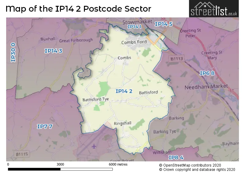
The IP14 2 Postcode shares a border with IP6 8 (Needham Market, Creeting St. Mary, Barking), IP7 7 (Bildeston, Hitcham, Wattisham Airfield), IP14 1 (STOWMARKET, Onehouse), IP14 3 (Haughley, Great Finborough, Onehouse), IP14 5 (STOWMARKET, Mendlesham, Wetheringsett) and IP8 4 (Bramford, Lower Somersham, Offton).
The sector is within the post town of STOWMARKET.
IP14 2 is a postcode sector within the IP14 postcode district which is within the IP Ipswich postcode area.
The Royal Mail delivery office for the IP14 2 postal sector is the Stowmarket Delivery Office.
The area of the IP14 2 postcode sector is 10.77 square miles which is 27.91 square kilometres or 6,895.56 square acres.
Waterways within the IP14 2 postcode sector include the River Gipping.

Map of the IP14 2 Postcode Sector
Explore the IP14 2 postcode sector by using our free interactive map.
| I | P | 1 | 4 | - | 2 | X | X |
| I | P | 1 | 4 | Space | 2 | Letter | Letter |
Official List of Streets
STOWMARKET (74 Streets)
Battisford (13 Streets)
Combs (23 Streets)
Little Finborough (1 Streets)
Unofficial Streets or Alternative Spellings
Needham Market
STOWMARKET ROAD BADLEY LANE BURNTHOUSE LANE CAGMANS LANE CARTERS LANE CITY LANE GIPPING VALLEY RIVER PATH HASCOT HILL LABURNUM DRIVE STOWMARKET ROAD TAYLORS FARM VALLEY LANE WARE ROADSTOWMARKET
BRIDGE STREET GIPPING WAY IPSWICH ROADGreat Finborough
COMBS LANE VALLEY LANEWeather Forecast for IP14 2
Press Button to Show Forecast for Wattisham
| Time Period | Icon | Description | Temperature | Rain Probability | Wind |
|---|---|---|---|---|---|
| 09:00 to 12:00 | Partly cloudy (day) | 8.0°C (feels like 6.0°C) | 1.00% | NE 7 mph | |
| 12:00 to 15:00 | Cloudy | 10.0°C (feels like 9.0°C) | 7.00% | ENE 7 mph | |
| 15:00 to 18:00 | Overcast | 9.0°C (feels like 8.0°C) | 11.00% | ESE 9 mph | |
| 18:00 to 21:00 | Cloudy | 8.0°C (feels like 7.0°C) | 10.00% | E 9 mph | |
| 21:00 to 00:00 | Cloudy | 5.0°C (feels like 3.0°C) | 8.00% | ENE 7 mph |
Press Button to Show Forecast for Wattisham
| Time Period | Icon | Description | Temperature | Rain Probability | Wind |
|---|---|---|---|---|---|
| 00:00 to 03:00 | Cloudy | 4.0°C (feels like 2.0°C) | 11.00% | NE 7 mph | |
| 03:00 to 06:00 | Cloudy | 4.0°C (feels like 1.0°C) | 12.00% | NE 7 mph | |
| 06:00 to 09:00 | Cloudy | 5.0°C (feels like 2.0°C) | 19.00% | NE 9 mph | |
| 09:00 to 12:00 | Cloudy | 10.0°C (feels like 7.0°C) | 14.00% | E 11 mph | |
| 12:00 to 15:00 | Overcast | 11.0°C (feels like 9.0°C) | 17.00% | E 11 mph | |
| 15:00 to 18:00 | Cloudy | 12.0°C (feels like 10.0°C) | 13.00% | E 11 mph | |
| 18:00 to 21:00 | Cloudy | 10.0°C (feels like 8.0°C) | 18.00% | ENE 11 mph | |
| 21:00 to 00:00 | Light rain | 9.0°C (feels like 6.0°C) | 51.00% | ENE 11 mph |
Press Button to Show Forecast for Wattisham
| Time Period | Icon | Description | Temperature | Rain Probability | Wind |
|---|---|---|---|---|---|
| 00:00 to 03:00 | Light rain shower (night) | 9.0°C (feels like 7.0°C) | 42.00% | ENE 11 mph | |
| 03:00 to 06:00 | Heavy rain | 9.0°C (feels like 7.0°C) | 77.00% | ESE 9 mph | |
| 06:00 to 09:00 | Light rain shower (day) | 9.0°C (feels like 7.0°C) | 40.00% | SE 9 mph | |
| 09:00 to 12:00 | Light rain shower (day) | 11.0°C (feels like 9.0°C) | 42.00% | SSE 13 mph | |
| 12:00 to 15:00 | Light rain shower (day) | 11.0°C (feels like 8.0°C) | 40.00% | S 16 mph | |
| 15:00 to 18:00 | Heavy rain shower (day) | 13.0°C (feels like 10.0°C) | 57.00% | SSW 16 mph | |
| 18:00 to 21:00 | Partly cloudy (day) | 12.0°C (feels like 10.0°C) | 12.00% | SW 11 mph | |
| 21:00 to 00:00 | Partly cloudy (night) | 9.0°C (feels like 7.0°C) | 6.00% | WSW 9 mph |
Schools and Places of Education Within the IP14 2 Postcode Sector
Ringshall School
Academy converter
Offton Road, Stowmarket, Suffolk, IP14 2JD
Head: Mr James Gough
Ofsted Rating: Good
Inspection: 2023-12-13 (135 days ago)
Website: Visit Ringshall School Website
Phone: 01473658307
Number of Pupils: 123
Trinity Church of England Voluntary Aided Primary School
Voluntary aided school
Lavenham Way, Stowmarket, Suffolk, IP14 2BZ
Head: Mrs Linda Curran-Spain
Ofsted Rating: Good
Inspection: 2019-06-05 (1787 days ago)
Website: Visit Trinity Church of England Voluntary Aided Primary School Website
Phone: 01449770462
Number of Pupils: 164
House Prices in the IP14 2 Postcode Sector
| Type of Property | 2018 Average | 2018 Sales | 2017 Average | 2017 Sales | 2016 Average | 2016 Sales | 2015 Average | 2015 Sales |
|---|---|---|---|---|---|---|---|---|
| Detached | £308,623 | 54 | £320,531 | 59 | £348,589 | 44 | £300,637 | 47 |
| Semi-Detached | £203,683 | 26 | £215,878 | 35 | £208,265 | 32 | £184,352 | 27 |
| Terraced | £176,228 | 23 | £188,079 | 19 | £169,426 | 23 | £148,378 | 33 |
| Flats | £0 | 0 | £90,000 | 2 | £0 | 0 | £85,000 | 1 |
Important Postcodes IP14 2 in the Postcode Sector
IP14 2BD is the postcode for Stowmarket Community Centre, Hillside
IP14 2BZ is the postcode for Combs Middle School, Lavenham Way, and Trinity Cevap School, Lavenham Way
IP14 2JD is the postcode for Ringshall Primary School, Offton Road, and Ringshall Primary School, Offton Road, Ringshall
IP14 2PN is the postcode for Combs Ford Primary School, Glemsford Road
IP14 2SY is the postcode for Combs Ford Surgery, Combs Lane
| The IP14 2 Sector is within these Local Authorities |
|
|---|---|
| The IP14 2 Sector is within these Counties |
|
| The IP14 2 Sector is within these Water Company Areas |
|