The KT15 1 postcode sector is within the county of Surrey.
Did you know? According to the 2021 Census, the KT15 1 postcode sector is home to a bustling 10,587 residents!
Given that each sector allows for 400 unique postcode combinations. Letters C, I, K, M, O and V are not allowed in the last two letters of a postcode. With 240 postcodes already in use, this leaves 160 units available.
The largest settlements in the KT15 1 postal code are ADDLESTONE and OTTERSHAW .
The KT15 1 Postcode shares a border with KT15 2 (ADDLESTONE , MEADOWLANDS PARK , MEADOWLANDS ), KT15 3 (ADDLESTONE , NEW HAW , WOODHAM ), KT16 0 (CHERTSEY, OTTERSHAW, Longcross) and KT16 9 (CHERTSEY).
The sector is within the post town of ADDLESTONE.
KT15 1 is a postcode sector within the KT15 postcode district which is within the KT Kingston upon Thames postcode area.
The Royal Mail delivery office for the KT15 1 postal sector is the Addlestone Delivery Office.
The area of the KT15 1 postcode sector is 1.55 square miles which is 4.01 square kilometres or 990.52 square acres.
The KT15 1 postcode sector is crossed by the M25 motorway.
Waterways within the KT15 1 postcode sector include the River Bourne.

Map of the KT15 1 Postcode Sector
Explore the KT15 1 postcode sector by using our free interactive map.
| K | T | 1 | 5 | - | 1 | X | X |
| K | T | 1 | 5 | Space | 1 | Letter | Letter |
Official List of Streets
ADDLESTONE (118 Streets)
Unofficial Streets or Alternative Spellings
ADDLESTONE
BOURNE WAY CROCKFORD PARK ROAD CROUCH OAK LANE NEW HAW ROAD PRINCESS PARK STATION ROAD ADDLESTONE INTERCHANGE BRENTWOOD COURT BROCKHURST ROAD BROOCKHURST ROAD COOMBELANDS GARDENS FRANKLANDS PARK EXERCISE TRACK FRANKLANDS PARK LOOP TRAIL PINE COURT SAINT PETERS WAY ST PETERS WAY TEMPLE FIELD CLOSEWoodham
WOODHAM PARK ROADOttershaw
BROX LANE MURRAY ROADCHERTSEY
BITTAMS LANE CROSSLANDS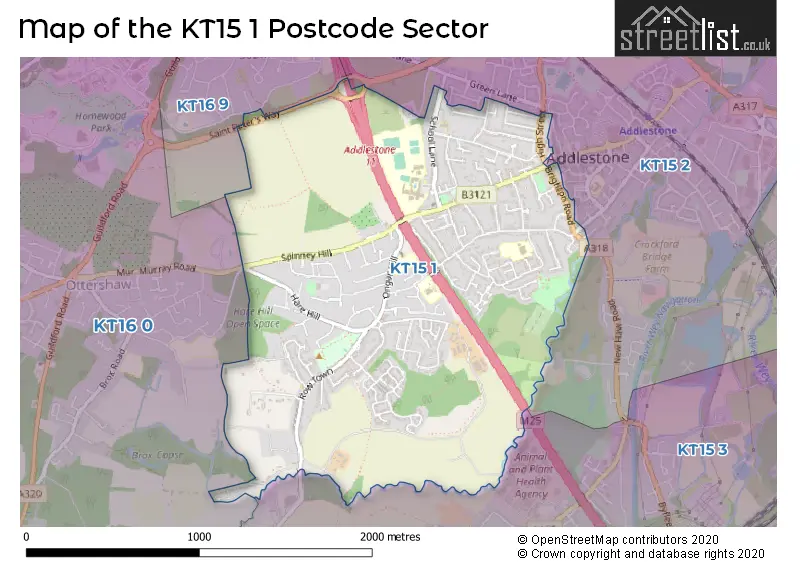
House Prices in the KT15 1 Postcode Sector
| Type of Property | 2018 Average | 2018 Sales | 2017 Average | 2017 Sales | 2016 Average | 2016 Sales | 2015 Average | 2015 Sales |
|---|---|---|---|---|---|---|---|---|
| Detached | £528,271 | 35 | £599,114 | 33 | £527,303 | 33 | £492,707 | 40 |
| Semi-Detached | £430,854 | 68 | £431,365 | 64 | £427,679 | 57 | £389,517 | 52 |
| Terraced | £341,964 | 28 | £344,673 | 42 | £339,544 | 31 | £287,468 | 33 |
| Flats | £234,409 | 28 | £236,813 | 36 | £240,070 | 46 | £202,964 | 51 |
Important Postcodes KT15 1 in the Postcode Sector
KT15 1BP is the postcode for Holy Family Catholic Primary School, Ongar Hill
KT15 1HH is the postcode for Rodwell Farm Nursing Home, Rowtown
KT15 1NB is the postcode for Sayes Court Primary School, Sayes Court Farm Drive
KT15 1NY is the postcode for Ongar Place Primary School, Milton Road, and Ongar Place Infant School, Milton Road
KT15 1TB is the postcode for Achieve POWER, School Lane, and Addlestone Health & Fitness, School Lane
KT15 1TD is the postcode for Addlestone Leisure Centre, School Lane, St. Pauls First School, School Lane, and St. Pauls Primary School, School Lane
KT15 1TE is the postcode for Jubilee High School, School Lane, CDT BLOCK, Jubilee High School, School Lane, SPORTS CENTRE, Jubilee High School, School Lane, and MAIN BUILDING, Jubilee High School, School Lane
| The KT15 1 Sector is within these Local Authorities |
|
|---|---|
| The KT15 1 Sector is within these Counties |
|
| The KT15 1 Sector is within these Water Company Areas |
|