The KT15 2 postcode sector is within the county of Surrey.
Did you know? According to the 2021 Census, the KT15 2 postcode sector is home to a bustling 10,113 residents!
Given that each sector allows for 400 unique postcode combinations. Letters C, I, K, M, O and V are not allowed in the last two letters of a postcode. With 274 postcodes already in use, this leaves 126 units available.
The largest settlement in the KT15 2 postal code is ADDLESTONE followed by MEADOWLANDS PARK , and MEADOWLANDS .
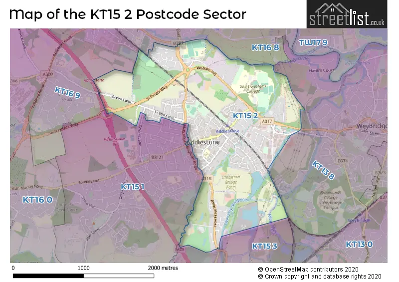
The KT15 2 Postcode shares a border with KT13 8 (WEYBRIDGE , ADDLESTONE ), KT15 1 (ADDLESTONE , OTTERSHAW ), KT15 3 (ADDLESTONE , NEW HAW , WOODHAM ), KT16 8 (CHERTSEY, PENTON PARK), KT13 0 (WEYBRIDGE , BROOKLANDS INDUSTRIAL PARK ) and KT16 9 (CHERTSEY).
The sector is within the post town of ADDLESTONE.
KT15 2 is a postcode sector within the KT15 postcode district which is within the KT Kingston upon Thames postcode area.
The Royal Mail delivery office for the KT15 2 postal sector is the Addlestone Delivery Office.
The area of the KT15 2 postcode sector is 1.75 square miles which is 4.52 square kilometres or 1,117.63 square acres.
The KT15 2 postcode sector is crossed by the M25 motorway.
Waterways within the KT15 2 postcode sector include the River Bourne, Wey Navigation, River Wey.

Map of the KT15 2 Postcode Sector
Explore the KT15 2 postcode sector by using our free interactive map.
| K | T | 1 | 5 | - | 2 | X | X |
| K | T | 1 | 5 | Space | 2 | Letter | Letter |
Official List of Streets
ADDLESTONE (96 Streets)
Bourne Business Park (2 Streets)
Unofficial Streets or Alternative Spellings
ADDLESTONE
BRIGHTON ROAD CHAPEL PARK ROAD CHURCH ROAD HIGH STREET MARSH LANE RICKMAN COURT SCHOOL LANE ADDLESTONE INTERCHANGE ADDLESTONE MOOR CYCLE PATH AVENUE C AVENUE ONE AVENUE THREE AVENUE TWO BLACK BOY BRIDGE CHERTSEY ROAD CYCLE PATH CHURCH MEWS CROCKFORD BRIDGE HAZELDENE JAY AVENUE KAY AVENUE LINK ROAD MAIN STREET NEW SITE NIGHTINGALE RISE OAKLANDS COURT RIVER WEY NAVIGATION PATH ST PETERS WAY THE OLD DAIRY THE RETREAT WATERS EDGE WOBURN HALL WOODLANDSADDLESTONE,
GREEN LANESchools and Places of Education Within the KT15 2 Postcode Sector
Chertsey High School
Free schools
Chertsey Road, Addlestone, , KT15 2EP
Head: Mrs Mary Gould
Ofsted Rating: Good
Inspection: 2022-02-23 (830 days ago)
Website: Visit Chertsey High School Website
Phone: 01932598020
Number of Pupils: 846
House Prices in the KT15 2 Postcode Sector
| Type of Property | 2018 Average | 2018 Sales | 2017 Average | 2017 Sales | 2016 Average | 2016 Sales | 2015 Average | 2015 Sales |
|---|---|---|---|---|---|---|---|---|
| Detached | £554,769 | 13 | £497,659 | 28 | £509,298 | 22 | £434,232 | 17 |
| Semi-Detached | £414,057 | 53 | £444,694 | 49 | £405,992 | 48 | £352,829 | 49 |
| Terraced | £402,459 | 32 | £454,864 | 45 | £415,333 | 40 | £339,563 | 38 |
| Flats | £274,128 | 80 | £261,253 | 102 | £246,283 | 72 | £209,457 | 73 |
Important Postcodes KT15 2 in the Postcode Sector
KT15 2AA is the postcode for Royal Mail, Addlestone Delivery Office, 76 Station Road
KT15 2AH is the postcode for Runnymede Borough Council, Runnymede Civic Centre, Station Road
KT15 2BH is the postcode for Addlestone Health Centre, 45 Station Road
KT15 2EP is the postcode for Runnymede Youth & Adult Education Centre, Runnymede Centre, Chertsey Road, and THE MEADS, Runnymede Youth & Adult Education Centre, Runnymede Centre, Chertsey Road
KT15 2NP is the postcode for Darley Dene Cp School, Garfield Road, Darley Dene Primary School, Garfield Road, MAIN BUILDING, Darley Dene Infant and Nursery School, Garfield Road, and Darley Dene Infant and Nursery School, Garfield Road
KT15 2QH is the postcode for Philip Southcote School, Addlestone Moor, and Surrey Fire & Rescue Service, Fire Station, Addlestone Moor
| The KT15 2 Sector is within these Local Authorities |
|
|---|---|
| The KT15 2 Sector is within these Counties |
|
| The KT15 2 Sector is within these Water Company Areas |
|