The L13 6 postcode sector is within the county of Merseyside.
Did you know? According to the 2021 Census, the L13 6 postcode sector is home to a bustling 3,250 residents!
Given that each sector allows for 400 unique postcode combinations. Letters C, I, K, M, O and V are not allowed in the last two letters of a postcode. With 50 postcodes already in use, this leaves 350 units available.
The largest settlement in the L13 6 postal code is LIVERPOOL followed by Stoneycroft, and Old Swan.
The L13 6 Postcode shares a border with L13 0 (LIVERPOOL, West Derby, Stoneycroft), L13 3 (LIVERPOOL, Old Swan), L13 5 (LIVERPOOL, Old Swan, Stoneycroft) and L13 7 (LIVERPOOL, Stoneycroft, Old Swan).
The sector is within the post town of LIVERPOOL.
L13 6 is a postcode sector within the L1 postcode district which is within the L Liverpool postcode area.
The Royal Mail delivery office for the L13 6 postal sector is the Liverpool 1-3.
The area of the L13 6 postcode sector is 0.14 square miles which is 0.37 square kilometres or 90.39 square acres.

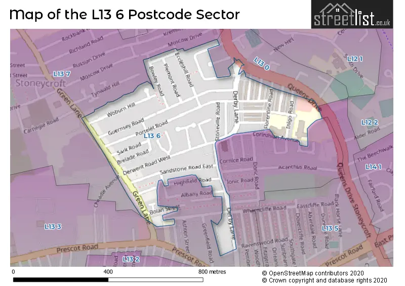
Map of the L13 6 Postcode Sector
Explore the L13 6 postcode sector by using our free interactive map.
| L | 1 | 3 | - | 6 | X | X |
| L | 1 | 3 | Space | 6 | Letter | Letter |
Official List of Streets
LIVERPOOL (33 Streets)
Old Swan (1 Streets)
Stoneycroft (1 Streets)
Unofficial Streets or Alternative Spellings
LIVERPOOL
ABACUS ROAD ACANTHUS ROAD BROOKLAND ROAD EAST BROOKLAND ROAD WEST CHEADLE AVENUE CORINTHIAN AVENUE CORNICE ROAD ETRUSCAN ROAD GREENVILLE WAY HIGHFIELD VIEW RAVENSWOOD ROAD SHAFTESBURY TERRACE STONEYCROFT CLOSE WHARNCLIFFE ROAD WOODCHURCH ROAD WOODGREEN ROAD ETNA STREET QUEENS DRIVE STONEYCROFT QUEENS DRIVE WEST DERBYOld Swan
ALBANY ROAD EVENSON WAY GREEN LANE HIGHFIELD ROADStoneycroft
QUEENS DRIVEWeather Forecast for L13 6
Press Button to Show Forecast for West Derby
| Time Period | Icon | Description | Temperature | Rain Probability | Wind |
|---|---|---|---|---|---|
| 03:00 to 06:00 | Cloudy | 10.0°C (feels like 7.0°C) | 7.00% | SSE 16 mph | |
| 06:00 to 09:00 | Cloudy | 10.0°C (feels like 6.0°C) | 5.00% | SE 16 mph | |
| 09:00 to 12:00 | Cloudy | 12.0°C (feels like 8.0°C) | 8.00% | SE 18 mph | |
| 12:00 to 15:00 | Cloudy | 15.0°C (feels like 11.0°C) | 9.00% | SSE 18 mph | |
| 15:00 to 18:00 | Cloudy | 15.0°C (feels like 12.0°C) | 15.00% | SSE 16 mph | |
| 18:00 to 21:00 | Light rain shower (day) | 13.0°C (feels like 11.0°C) | 35.00% | SSE 11 mph | |
| 21:00 to 00:00 | Cloudy | 12.0°C (feels like 10.0°C) | 16.00% | SE 9 mph |
Press Button to Show Forecast for West Derby
| Time Period | Icon | Description | Temperature | Rain Probability | Wind |
|---|---|---|---|---|---|
| 00:00 to 03:00 | Cloudy | 10.0°C (feels like 9.0°C) | 9.00% | SE 7 mph | |
| 03:00 to 06:00 | Cloudy | 9.0°C (feels like 8.0°C) | 4.00% | SE 7 mph | |
| 06:00 to 09:00 | Cloudy | 9.0°C (feels like 7.0°C) | 4.00% | SE 7 mph | |
| 09:00 to 12:00 | Cloudy | 11.0°C (feels like 10.0°C) | 5.00% | ESE 7 mph | |
| 12:00 to 15:00 | Cloudy | 14.0°C (feels like 13.0°C) | 8.00% | SE 7 mph | |
| 15:00 to 18:00 | Cloudy | 15.0°C (feels like 14.0°C) | 13.00% | SSE 7 mph | |
| 18:00 to 21:00 | Cloudy | 14.0°C (feels like 13.0°C) | 12.00% | WNW 7 mph | |
| 21:00 to 00:00 | Cloudy | 13.0°C (feels like 12.0°C) | 11.00% | NW 7 mph |
Press Button to Show Forecast for West Derby
| Time Period | Icon | Description | Temperature | Rain Probability | Wind |
|---|---|---|---|---|---|
| 00:00 to 03:00 | Cloudy | 12.0°C (feels like 10.0°C) | 12.00% | NNW 7 mph | |
| 03:00 to 06:00 | Cloudy | 11.0°C (feels like 10.0°C) | 9.00% | NNW 7 mph | |
| 06:00 to 09:00 | Cloudy | 11.0°C (feels like 10.0°C) | 7.00% | NNW 7 mph | |
| 09:00 to 12:00 | Partly cloudy (day) | 13.0°C (feels like 11.0°C) | 5.00% | N 9 mph | |
| 12:00 to 15:00 | Sunny day | 16.0°C (feels like 14.0°C) | 5.00% | N 9 mph | |
| 15:00 to 18:00 | Sunny day | 17.0°C (feels like 15.0°C) | 3.00% | N 11 mph | |
| 18:00 to 21:00 | Sunny day | 17.0°C (feels like 14.0°C) | 4.00% | N 11 mph | |
| 21:00 to 00:00 | Clear night | 14.0°C (feels like 12.0°C) | 3.00% | NNE 9 mph |
Schools and Places of Education Within the L13 6 Postcode Sector
Corinthian Community Primary School
Community school
Inigo Road, Liverpool, Merseyside, L13 6SH
Head: Andy Hudson
Ofsted Rating: Good
Inspection: 2021-11-04 (908 days ago)
Website: Visit Corinthian Community Primary School Website
Phone: 01512285806
Number of Pupils: 388
House Prices in the L13 6 Postcode Sector
| Type of Property | 2018 Average | 2018 Sales | 2017 Average | 2017 Sales | 2016 Average | 2016 Sales | 2015 Average | 2015 Sales |
|---|---|---|---|---|---|---|---|---|
| Detached | £110,000 | 1 | £0 | 0 | £0 | 0 | £105,875 | 4 |
| Semi-Detached | £138,833 | 9 | £160,573 | 13 | £121,611 | 9 | £128,417 | 6 |
| Terraced | £107,688 | 32 | £99,961 | 35 | £107,647 | 35 | £99,384 | 22 |
| Flats | £89,325 | 10 | £52,667 | 3 | £36,750 | 4 | £40,000 | 1 |
Important Postcodes L13 6 in the Postcode Sector
L13 6QD is the postcode for Stoneycroft Medical Centre, Stoneville Road
L13 6QJ is the postcode for Childrens Centre, 38 Scotia Road
L13 6SH is the postcode for Corinthian Cp School, Inigo Road
| The L13 6 Sector is within these Local Authorities |
|
|---|---|
| The L13 6 Sector is within these Counties |
|
| The L13 6 Sector is within these Water Company Areas |
|