The L14 5 postcode sector is within the county of Merseyside.
Did you know? According to the 2021 Census, the L14 5 postcode sector is home to a bustling 1,439 residents!
Given that each sector allows for 400 unique postcode combinations. Letters C, I, K, M, O and V are not allowed in the last two letters of a postcode. With 30 postcodes already in use, this leaves 370 units available.
The L14 5 postal code covers the settlement of LIVERPOOL.
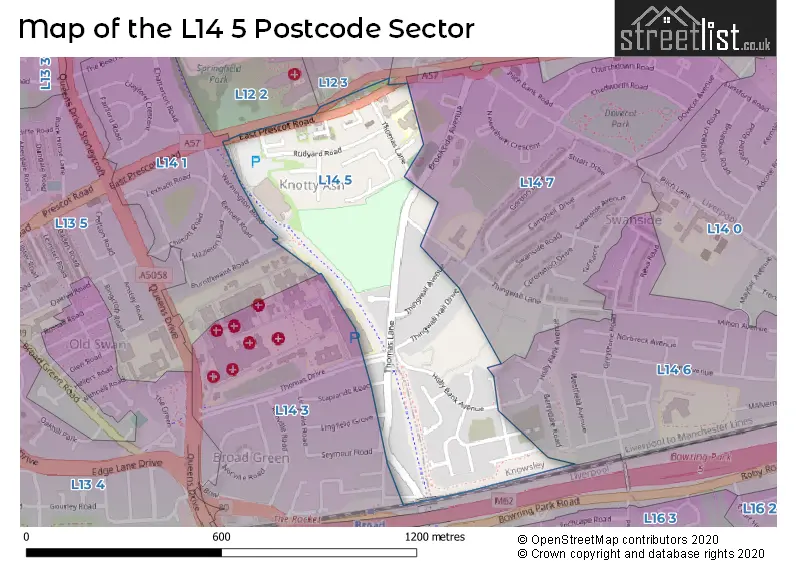
The L14 5 Postcode shares a border with L12 3 (LIVERPOOL, Knotty Ash, West Derby), L12 2 (West Derby, LIVERPOOL, Sandfield Park), L14 1 (LIVERPOOL), L14 2 (LIVERPOOL), L14 3 (LIVERPOOL, Broadgreen, Bowring Park), L14 6 (LIVERPOOL, Broadgreen, Bowring Park) and L14 7 (LIVERPOOL, Knotty Ash, Dovecot).
The sector is within the post town of LIVERPOOL.
L14 5 is a postcode sector within the L1 postcode district which is within the L Liverpool postcode area.
The Royal Mail delivery office for the L14 5 postal sector is the Liverpool 1-3.
The area of the L14 5 postcode sector is 0.21 square miles which is 0.54 square kilometres or 134.19 square acres.

Map of the L14 5 Postcode Sector
Explore the L14 5 postcode sector by using our free interactive map.
| L | 1 | 4 | - | 5 | X | X |
| L | 1 | 4 | Space | 5 | Letter | Letter |
Official List of Streets
LIVERPOOL (12 Streets)
Unofficial Streets or Alternative Spellings
LIVERPOOL
BURNTHWAITE ROAD HOLLY BANK AVENUE LINGFIELD GROVE OLD THOMAS LANE STAPLANDS ROAD THINGWALL LANE THOMAS DRIVE WARMINGTON ROAD BRADFIELD ROAD CROWTHER ROAD EVINGTON DRIVE FRIARS WAY LITTLEDALE LIVERPOOL LOOP LINE MARWOOD ROAD MERCHANT GROVE ROAD OAKVALE ROAD SANDOWN AVENUE SOUTH ROAD TRESWELL ROADKnotty Ash
BROOKSIDE AVENUEWest Derby
EATON ROADBroadgreen
SEYMOUR ROADWeather Forecast for L14 5
Press Button to Show Forecast for Knotty Ash
| Time Period | Icon | Description | Temperature | Rain Probability | Wind |
|---|---|---|---|---|---|
| 06:00 to 09:00 | Cloudy | 10.0°C (feels like 6.0°C) | 5.00% | SE 16 mph | |
| 09:00 to 12:00 | Cloudy | 12.0°C (feels like 8.0°C) | 8.00% | SE 18 mph | |
| 12:00 to 15:00 | Cloudy | 14.0°C (feels like 11.0°C) | 9.00% | SSE 18 mph | |
| 15:00 to 18:00 | Cloudy | 15.0°C (feels like 12.0°C) | 15.00% | SSE 16 mph | |
| 18:00 to 21:00 | Light rain shower (day) | 13.0°C (feels like 11.0°C) | 35.00% | SSE 11 mph | |
| 21:00 to 00:00 | Cloudy | 11.0°C (feels like 10.0°C) | 16.00% | SE 9 mph |
Press Button to Show Forecast for Knotty Ash
| Time Period | Icon | Description | Temperature | Rain Probability | Wind |
|---|---|---|---|---|---|
| 00:00 to 03:00 | Cloudy | 10.0°C (feels like 9.0°C) | 8.00% | SE 7 mph | |
| 03:00 to 06:00 | Cloudy | 9.0°C (feels like 8.0°C) | 4.00% | SE 7 mph | |
| 06:00 to 09:00 | Cloudy | 9.0°C (feels like 7.0°C) | 4.00% | SE 7 mph | |
| 09:00 to 12:00 | Cloudy | 11.0°C (feels like 10.0°C) | 5.00% | ESE 7 mph | |
| 12:00 to 15:00 | Cloudy | 14.0°C (feels like 13.0°C) | 8.00% | SE 7 mph | |
| 15:00 to 18:00 | Cloudy | 15.0°C (feels like 14.0°C) | 13.00% | SSE 7 mph | |
| 18:00 to 21:00 | Cloudy | 14.0°C (feels like 13.0°C) | 12.00% | WNW 7 mph | |
| 21:00 to 00:00 | Cloudy | 13.0°C (feels like 12.0°C) | 11.00% | NW 7 mph |
Press Button to Show Forecast for Knotty Ash
| Time Period | Icon | Description | Temperature | Rain Probability | Wind |
|---|---|---|---|---|---|
| 00:00 to 03:00 | Cloudy | 12.0°C (feels like 10.0°C) | 12.00% | NNW 7 mph | |
| 03:00 to 06:00 | Cloudy | 11.0°C (feels like 10.0°C) | 9.00% | NNW 7 mph | |
| 06:00 to 09:00 | Cloudy | 11.0°C (feels like 10.0°C) | 7.00% | NNW 7 mph | |
| 09:00 to 12:00 | Partly cloudy (day) | 13.0°C (feels like 11.0°C) | 5.00% | N 9 mph | |
| 12:00 to 15:00 | Sunny day | 16.0°C (feels like 14.0°C) | 5.00% | N 9 mph | |
| 15:00 to 18:00 | Sunny day | 17.0°C (feels like 15.0°C) | 3.00% | N 11 mph | |
| 18:00 to 21:00 | Sunny day | 17.0°C (feels like 14.0°C) | 4.00% | N 11 mph | |
| 21:00 to 00:00 | Clear night | 14.0°C (feels like 12.0°C) | 3.00% | NNE 9 mph |
Schools and Places of Education Within the L14 5 Postcode Sector
Knotty Ash Primary School
Community school
Thomas Lane, Liverpool, Merseyside, L14 5NX
Head: Mrs Roanne Clements-Bedson
Ofsted Rating: Good
Inspection: 2022-03-16 (776 days ago)
Website: Visit Knotty Ash Primary School Website
Phone: 01512284222
Number of Pupils: 254
House Prices in the L14 5 Postcode Sector
| Type of Property | 2018 Average | 2018 Sales | 2017 Average | 2017 Sales | 2016 Average | 2016 Sales | 2015 Average | 2015 Sales |
|---|---|---|---|---|---|---|---|---|
| Detached | £168,000 | 1 | £0 | 0 | £0 | 0 | £0 | 0 |
| Semi-Detached | £147,542 | 6 | £158,154 | 13 | £165,893 | 14 | £169,809 | 11 |
| Terraced | £103,063 | 8 | £113,279 | 7 | £118,667 | 3 | £102,167 | 6 |
| Flats | £0 | 0 | £85,000 | 1 | £0 | 0 | £0 | 0 |
Important Postcodes L14 5 in the Postcode Sector
L14 5NA is the postcode for Knotty Ash Village Community Centre, 251 East Prescot Road
L14 5NX is the postcode for Knotty Ash Cp School, Thomas Lane
| The L14 5 Sector is within these Local Authorities |
|
|---|---|
| The L14 5 Sector is within these Counties |
|
| The L14 5 Sector is within these Water Company Areas |
|