The L17 6 postcode sector is within the county of Merseyside.
Did you know? According to the 2021 Census, the L17 6 postcode sector is home to a bustling 2,613 residents!
Given that each sector allows for 400 unique postcode combinations. Letters C, I, K, M, O and V are not allowed in the last two letters of a postcode. With 63 postcodes already in use, this leaves 337 units available.
The largest settlements in the L17 6 postal code are LIVERPOOL and Aigburth.
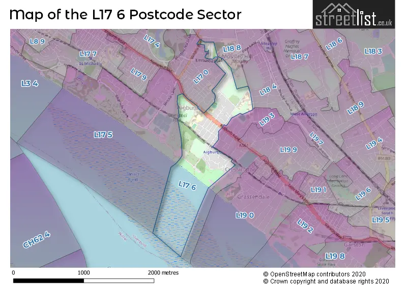
The L17 6 Postcode shares a border with L18 4 (LIVERPOOL), L17 5 (LIVERPOOL), L18 8 (LIVERPOOL, Mossley Hill), L17 0 (LIVERPOOL, Aigburth) and L19 3 (LIVERPOOL, Aigburth).
The sector is within the post town of LIVERPOOL.
L17 6 is a postcode sector within the L1 postcode district which is within the L Liverpool postcode area.
The Royal Mail delivery office for the L17 6 postal sector is the Liverpool 1-3.
The area of the L17 6 postcode sector is 0.37 square miles which is 0.97 square kilometres or 239.11 square acres.

Map of the L17 6 Postcode Sector
Explore the L17 6 postcode sector by using our free interactive map.
| L | 1 | 7 | - | 6 | X | X |
| L | 1 | 7 | Space | 6 | Letter | Letter |
Official List of Streets
LIVERPOOL (28 Streets)
Unofficial Streets or Alternative Spellings
LIVERPOOL
BIRCHTREE ROAD BRABANT ROAD CHERMSIDE ROAD CROMER ROAD DESFORD ROAD DUNDONALD ROAD HAILSHAM ROAD HOLLYWOOD ROAD MILNER ROAD MOSSLEY HILL ROAD NETHERTON ROAD OTTERSPOOL DRIVE RANGEMORE ROAD THE SPINNAKERS TULLIMORE ROADAigburth
ASHLAR ROAD RIVERSDALE ROAD WOODLANDS ROAD BENTFIELD CHURCH LANE ERRINGTON COURT SAINT ANNES GARDENS SAINT ANNES GROVE SAINT ANNES ROAD THE ORCHARDWeather Forecast for L17 6
Press Button to Show Forecast for Grassendale
| Time Period | Icon | Description | Temperature | Rain Probability | Wind |
|---|---|---|---|---|---|
| 06:00 to 09:00 | Cloudy | 10.0°C (feels like 6.0°C) | 5.00% | SE 18 mph | |
| 09:00 to 12:00 | Cloudy | 12.0°C (feels like 8.0°C) | 8.00% | SE 18 mph | |
| 12:00 to 15:00 | Cloudy | 15.0°C (feels like 11.0°C) | 9.00% | SSE 18 mph | |
| 15:00 to 18:00 | Cloudy | 15.0°C (feels like 11.0°C) | 15.00% | SSE 16 mph | |
| 18:00 to 21:00 | Light rain shower (day) | 13.0°C (feels like 11.0°C) | 35.00% | SSE 11 mph | |
| 21:00 to 00:00 | Overcast | 11.0°C (feels like 10.0°C) | 16.00% | SE 9 mph |
Press Button to Show Forecast for Grassendale
| Time Period | Icon | Description | Temperature | Rain Probability | Wind |
|---|---|---|---|---|---|
| 00:00 to 03:00 | Cloudy | 10.0°C (feels like 9.0°C) | 7.00% | SE 9 mph | |
| 03:00 to 06:00 | Cloudy | 9.0°C (feels like 8.0°C) | 4.00% | SE 7 mph | |
| 06:00 to 09:00 | Cloudy | 9.0°C (feels like 7.0°C) | 4.00% | SE 7 mph | |
| 09:00 to 12:00 | Cloudy | 12.0°C (feels like 10.0°C) | 5.00% | ESE 7 mph | |
| 12:00 to 15:00 | Cloudy | 14.0°C (feels like 13.0°C) | 8.00% | SE 7 mph | |
| 15:00 to 18:00 | Cloudy | 15.0°C (feels like 14.0°C) | 13.00% | SSE 7 mph | |
| 18:00 to 21:00 | Cloudy | 15.0°C (feels like 13.0°C) | 12.00% | WNW 7 mph | |
| 21:00 to 00:00 | Cloudy | 13.0°C (feels like 12.0°C) | 11.00% | WNW 7 mph |
Press Button to Show Forecast for Grassendale
| Time Period | Icon | Description | Temperature | Rain Probability | Wind |
|---|---|---|---|---|---|
| 00:00 to 03:00 | Cloudy | 12.0°C (feels like 10.0°C) | 12.00% | N 7 mph | |
| 03:00 to 06:00 | Cloudy | 11.0°C (feels like 10.0°C) | 9.00% | NNW 7 mph | |
| 06:00 to 09:00 | Cloudy | 11.0°C (feels like 10.0°C) | 7.00% | NNW 7 mph | |
| 09:00 to 12:00 | Cloudy | 13.0°C (feels like 12.0°C) | 8.00% | N 9 mph | |
| 12:00 to 15:00 | Sunny day | 16.0°C (feels like 14.0°C) | 5.00% | N 9 mph | |
| 15:00 to 18:00 | Sunny day | 18.0°C (feels like 15.0°C) | 3.00% | N 11 mph | |
| 18:00 to 21:00 | Sunny day | 17.0°C (feels like 14.0°C) | 4.00% | N 11 mph | |
| 21:00 to 00:00 | Clear night | 14.0°C (feels like 12.0°C) | 3.00% | NNE 9 mph |
Schools and Places of Education Within the L17 6 Postcode Sector
Palmerston School
Community special school
Minehead Road, Liverpool, Merseyside, L17 6AU
Head: Mrs Alison Buckley
Ofsted Rating: Outstanding
Inspection: 2019-12-11 (1602 days ago)
Website: Visit Palmerston School Website
Phone: 01514282128
Number of Pupils: 149
St Margaret's Church of England Academy
Academy converter
Aigburth Road, Liverpool, Merseyside, L17 6AB
Head: Mrs Jeniffer Sing
Ofsted Rating: Requires improvement
Inspection: 2021-11-04 (908 days ago)
Website: Visit St Margaret's Church of England Academy Website
Phone: 01514271825
Number of Pupils: 1026
House Prices in the L17 6 Postcode Sector
| Type of Property | 2018 Average | 2018 Sales | 2017 Average | 2017 Sales | 2016 Average | 2016 Sales | 2015 Average | 2015 Sales |
|---|---|---|---|---|---|---|---|---|
| Detached | £404,295 | 10 | £369,286 | 7 | £496,278 | 9 | £360,318 | 15 |
| Semi-Detached | £295,000 | 2 | £269,136 | 11 | £305,905 | 11 | £289,543 | 13 |
| Terraced | £193,103 | 15 | £184,898 | 25 | £146,132 | 19 | £187,430 | 24 |
| Flats | £140,867 | 15 | £157,231 | 13 | £151,714 | 7 | £178,914 | 25 |
Important Postcodes L17 6 in the Postcode Sector
L17 6AB is the postcode for CRICKET & SPORTS CENTRE, St. Margarets C of E High School, Aigburth Road, CRICKET & SPORTS CENTRE, St. Margarets CofE Academy, Aigburth Road, CRICKET & SPORTS CENTRE, St. Margarets C of E Academy, Aigburth Road, MAIN SCHOOL BUILDING, St. Margarets CofE Academy, Aigburth Road, MAIN SCHOOL BUILDING, St. Margarets C of E Academy, Aigburth Road, and MAIN SCHOOL BUILDING, St. Margarets C of E High School, Aigburth Road
L17 6AU is the postcode for Palmerston School, 2a Minehead Road
L17 6AX is the postcode for Aigburth High School, Minehead Road, and Mersey View School, Minehead Road
L17 6BD is the postcode for SPORT HALL, Liverpool John Moores University, I M Marsh Campus, Barkhill Road, SUDLEY BUILDING, Liverpool John Moores University, I M Marsh Campus, Barkhill Road, HOMERFIELD HOUSE, Liverpool John Moores University, I M Marsh Campus, Barkhill Road, EGG DANCE STUDIO, Liverpool John Moores University, I M Marsh Campus, Barkhill Road, HOLMFIELD HOUSE, Liverpool John Moores University, I M Marsh Campus, Barkhill Road, NORTH BUILDING, Liverpool John Moores University, I M Marsh Campus, Barkhill Road, REFECTORY BUILDING, Liverpool John Moores University, I M Marsh Campus, Barkhill Road, BLOCK E, F, G, BARKHILL COURT, Liverpool John Moores University, I M Marsh Campus, Barkhill Road, BARKHILL AND MOSSLEY BUILDING, Liverpool John Moores University, I M Marsh Campus, Barkhill Road, GREENBANK AND LANGTON BUILDING, Liverpool John Moores University, I M Marsh Campus, Barkhill Road, and SCIENCE PRIMARY NORTH BUILDING, Liverpool John Moores University, I M Marsh Campus, Barkhill Road
L17 6BH is the postcode for Sudley Junior School, Aigburth Road
| The L17 6 Sector is within these Local Authorities |
|
|---|---|
| The L17 6 Sector is within these Counties |
|
| The L17 6 Sector is within these Water Company Areas |
|