The L25 0 postcode sector is within the county of Merseyside.
Did you know? According to the 2021 Census, the L25 0 postcode sector is home to a bustling 3,775 residents!
Given that each sector allows for 400 unique postcode combinations. Letters C, I, K, M, O and V are not allowed in the last two letters of a postcode. With 69 postcodes already in use, this leaves 331 units available.
The largest settlement in the L25 0 postal code is LIVERPOOL followed by Hunts Cross, and Woolton.
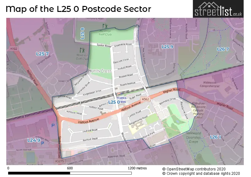
The L25 0 Postcode shares a border with L24 9 (LIVERPOOL, Speke, Halewood), L25 7 (Woolton, LIVERPOOL), L25 8 (LIVERPOOL, Woolton), L25 9 (LIVERPOOL, Hunts Cross, Woolton) and L26 1 (LIVERPOOL, Halewood).
The sector is within the post town of LIVERPOOL.
L25 0 is a postcode sector within the L25 postcode district which is within the L Liverpool postcode area.
The Royal Mail delivery office for the L25 0 postal sector is the Woolton Delivery Office.
The area of the L25 0 postcode sector is 0.40 square miles which is 1.04 square kilometres or 257.10 square acres.

Map of the L25 0 Postcode Sector
Explore the L25 0 postcode sector by using our free interactive map.
| L | 2 | 5 | - | 0 | X | X |
| L | 2 | 5 | Space | 0 | Letter | Letter |
Official List of Streets
LIVERPOOL (31 Streets)
Hunts Cross (4 Streets)
Woolton (3 Streets)
Unofficial Streets or Alternative Spellings
LIVERPOOL,
HIGHER ROADHunts Cross
YEW TREE ROADLIVERPOOL
STOWE CLOSESpeke
ADDENBROOKE DRIVE LIGHTSTREAM DRIVE TRIUMPH WAYSchools and Places of Education Within the L25 0 Postcode Sector
Hunts Cross Primary School
Community school
Kingsthorne Road, Liverpool, Merseyside, L25 0PJ
Head: Mrs Nicola Ware
Ofsted Rating: Good
Inspection: 2023-09-27 (239 days ago)
Website: Visit Hunts Cross Primary School Website
Phone: 01514861777
Number of Pupils: 355
House Prices in the L25 0 Postcode Sector
| Type of Property | 2018 Average | 2018 Sales | 2017 Average | 2017 Sales | 2016 Average | 2016 Sales | 2015 Average | 2015 Sales |
|---|---|---|---|---|---|---|---|---|
| Detached | £220,873 | 8 | £233,750 | 4 | £246,405 | 11 | £219,586 | 24 |
| Semi-Detached | £185,837 | 41 | £204,600 | 41 | £182,762 | 42 | £173,267 | 57 |
| Terraced | £170,417 | 6 | £144,119 | 8 | £147,667 | 3 | £124,125 | 8 |
| Flats | £0 | 0 | £105,000 | 2 | £64,750 | 2 | £120,000 | 1 |
Important Postcodes L25 0 in the Postcode Sector
L25 0PJ is the postcode for Hunts Cross Cp School, Kingsthorne Road
| The L25 0 Sector is within these Local Authorities |
|
|---|---|
| The L25 0 Sector is within these Counties |
|
| The L25 0 Sector is within these Water Company Areas |
|