The L25 postcode district is a postal district located in the L Liverpool postcode area with a population of 34,045 residents according to the 2021 England and Wales Census.
The area of the L25 postcode district is 3.88 square miles which is 10.04 square kilometres or 2,482.08 acres.
Currently, the L25 district has about 846 postcode units spread across 10 geographic postcode sectors.
Given that each sector allows for 400 unique postcode combinations, the district has a capacity of 4,000 postcodes. With 846 postcodes already in use, this leaves 3154 units available.
The largest settlement in the L25 postal code is LIVERPOOL followed by Woolton, and Hunts Cross.
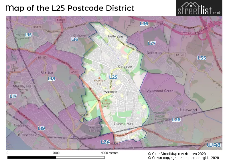
The L25 Postcode shares a border with L24 (LIVERPOOL, Speke, Hale Village), L19 (LIVERPOOL, Garston, Cressington), L18 (LIVERPOOL, Mossley Hill, Allerton), L16 (LIVERPOOL, Childwall) and L27 (LIVERPOOL, Netherley).
In the L25 postcode district, the primary settlement is Liverpool, which is located in the county of Merseyside. Woolton and Hunst Cross are other significant settlements within the district. The most significant post town in the L25 district is Liverpool.
For the district L25, we have data on 10 postcode sectors. Here's a breakdown: The sector L25 0, covers Liverpool and Hunts Cross in Merseyside. The sector L25 1, covers Liverpool in Merseyside. The sector L25 2, covers Liverpool in Merseyside. The sector L25 3, covers Liverpool in Merseyside. The sector L25 4, covers Liverpool in Merseyside. The sector L25 5, covers Liverpool in Merseyside. The sector L25 6, covers Liverpool and Woolton in Merseyside. The sector L25 7, covers Woolton and Liverpool in Merseyside. The sector L25 8, covers Liverpool and Woolton in Merseyside. The sector L25 9, covers Liverpool in Merseyside.


Map of the L25 Postcode District
Explore the L25 postcode district by using our free interactive map.
When it comes to local government, postal geography often disregards political borders. However, for a breakdown in the L25 District: the district mostly encompasses the Liverpool District (B) (747 postcodes), and finally, the Knowsley District (B) area (107 postcodes).
Recent House Sales in L25
| Date | Price | Address |
|---|---|---|
| 28/09/2023 | £545,000 | Gateacre Park Drive, Liverpool, L25 4RS |
| 28/09/2023 | £192,000 | Cranwell Road, Liverpool, L25 1NX |
| 25/09/2023 | £58,500 | Charlton Court, Woolton, Liverpool, L25 0QJ |
| 15/09/2023 | £375,000 | Manor Road, Woolton, Liverpool, L25 8QG |
| 15/09/2023 | £205,000 | Speke Hall Road, Liverpool, L25 0PS |
| 14/09/2023 | £105,000 | Dalebrook Close, Liverpool, L25 2YW |
| 08/09/2023 | £233,000 | Garway, Liverpool, L25 5LR |
| 01/09/2023 | £116,250 | Oakwood Close, Belle Vale, Liverpool, L25 2XZ |
| 01/09/2023 | £265,000 | Mackets Lane, Liverpool, L25 0LJ |
| 31/08/2023 | £320,000 | Wrekin Close, Liverpool, L25 8SP |
Weather Forecast for L25
Press Button to Show Forecast for Woolton
| Time Period | Icon | Description | Temperature | Rain Probability | Wind |
|---|---|---|---|---|---|
| 06:00 to 09:00 | Sunny day | 3.0°C (feels like 1.0°C) | 1.00% | E 4 mph | |
| 09:00 to 12:00 | Cloudy | 7.0°C (feels like 5.0°C) | 4.00% | E 4 mph | |
| 12:00 to 15:00 | Overcast | 9.0°C (feels like 8.0°C) | 9.00% | E 4 mph | |
| 15:00 to 18:00 | Cloudy | 10.0°C (feels like 9.0°C) | 9.00% | E 4 mph | |
| 18:00 to 21:00 | Cloudy | 9.0°C (feels like 8.0°C) | 6.00% | NNE 4 mph | |
| 21:00 to 00:00 | Cloudy | 6.0°C (feels like 4.0°C) | 8.00% | NE 7 mph |
Press Button to Show Forecast for Woolton
| Time Period | Icon | Description | Temperature | Rain Probability | Wind |
|---|---|---|---|---|---|
| 00:00 to 03:00 | Partly cloudy (night) | 5.0°C (feels like 2.0°C) | 6.00% | E 7 mph | |
| 03:00 to 06:00 | Partly cloudy (night) | 3.0°C (feels like 0.0°C) | 6.00% | E 7 mph | |
| 06:00 to 09:00 | Partly cloudy (day) | 4.0°C (feels like 1.0°C) | 5.00% | E 7 mph | |
| 09:00 to 12:00 | Partly cloudy (day) | 8.0°C (feels like 6.0°C) | 5.00% | ESE 7 mph | |
| 12:00 to 15:00 | Overcast | 10.0°C (feels like 8.0°C) | 14.00% | E 7 mph | |
| 15:00 to 18:00 | Light rain | 11.0°C (feels like 9.0°C) | 46.00% | ENE 9 mph | |
| 18:00 to 21:00 | Cloudy | 10.0°C (feels like 8.0°C) | 15.00% | ENE 9 mph | |
| 21:00 to 00:00 | Partly cloudy (night) | 7.0°C (feels like 5.0°C) | 13.00% | ENE 9 mph |
Press Button to Show Forecast for Woolton
| Time Period | Icon | Description | Temperature | Rain Probability | Wind |
|---|---|---|---|---|---|
| 00:00 to 03:00 | Cloudy | 6.0°C (feels like 3.0°C) | 17.00% | NE 7 mph | |
| 03:00 to 06:00 | Cloudy | 5.0°C (feels like 2.0°C) | 16.00% | NNE 9 mph | |
| 06:00 to 09:00 | Light rain | 6.0°C (feels like 3.0°C) | 49.00% | NNE 9 mph | |
| 09:00 to 12:00 | Light rain | 8.0°C (feels like 5.0°C) | 51.00% | N 9 mph | |
| 12:00 to 15:00 | Light rain | 9.0°C (feels like 6.0°C) | 54.00% | N 11 mph | |
| 15:00 to 18:00 | Heavy rain | 9.0°C (feels like 7.0°C) | 72.00% | N 11 mph | |
| 18:00 to 21:00 | Partly cloudy (day) | 10.0°C (feels like 8.0°C) | 14.00% | NW 11 mph | |
| 21:00 to 00:00 | Clear night | 7.0°C (feels like 5.0°C) | 11.00% | W 9 mph |
Where is the L25 Postcode District?
The data's postcode district is located in Liverpool. It is close to several nearby towns such as Prescot, Widnes, Ellesmere Port, Birkenhead, Runcorn, and Bootle. The distance from the postcode district to the center of London is approximately 173.37 miles.
The district is within the post town of LIVERPOOL.
The sector has postcodes within the nation of England.
The L25 Postcode District is covers the following regions.
- Liverpool - Merseyside - North West (England)
- East Merseyside - Merseyside - North West (England)
Postcode Sectors within the L25 District
| Postcode Sector | Delivery Office |
|---|---|
| L25 0 | Woolton Delivery Office |
| L25 1 | Woolton Delivery Office |
| L25 2 | Woolton Delivery Office |
| L25 3 | Woolton Delivery Office |
| L25 4 | Woolton Delivery Office |
| L25 5 | Woolton Delivery Office |
| L25 6 | Woolton Delivery Office |
| L25 7 | Woolton Delivery Office |
| L25 8 | Woolton Delivery Office |
| L25 9 | Woolton Delivery Office |
| L | 2 | 5 | - | X | X | X |
| L | 2 | 5 | Space | Numeric | Letter | Letter |
Tourist Attractions within the Postcode Area
We found 1 visitor attractions within the L25 postcode area
| Mendips & 20 Forthlin Road [Beatles] |
|---|
| Historic Properties |
| Historic House / House and Garden / Palace |
| View Mendips & 20 Forthlin Road [Beatles] on Google Maps |
Current Monthly Rental Prices
| # Bedrooms | Min Price | Max Price | Avg Price |
|---|---|---|---|
| £675 | £675 | £675 | |
| 1 | £675 | £775 | £733 |
| 2 | £875 | £1,395 | £1,054 |
| 3 | £995 | £1,250 | £1,123 |
| 4 | £2,000 | £2,000 | £2,000 |
| 5 | £1,250 | £1,250 | £1,250 |
| 7 | £4,750 | £4,750 | £4,750 |
Current House Prices
| # Bedrooms | Min Price | Max Price | Avg Price |
|---|---|---|---|
| £60,000 | £650,000 | £355,000 | |
| 1 | £70,000 | £145,000 | £101,429 |
| 2 | £90,000 | £375,000 | £220,476 |
| 3 | £75,000 | £650,000 | £314,901 |
| 4 | £165,000 | £895,000 | £412,279 |
| 5 | £395,000 | £1,200,000 | £754,900 |
| 6 | £425,000 | £650,000 | £537,500 |
| 8 | £55,300 | £1,625,000 | £840,150 |
Estate Agents who Operate in the L25 District
| Logo | Name | Brand Name | Address | Contact Number | Total Properties |
|---|---|---|---|---|---|
 | Mossley Hill | Move Residential | 52/54 Allerton Road, Mossley Hill, Liverpool, L18 1LN | 0151 453 1497 | 22 |
 | Woolton | Whitegates | 30a Allerton Road, Woolton, Liverpool, L25 7RG | 0151 453 3725 | 19 |
 | Allerton | Sutton Kersh | 38 Allerton Road Mossley Hill Liverpool L18 1LN | 0151 453 2272 | 18 |
 | Liverpool South | Century 21 Liverpool | 33 Allerton Road, Liverpool, L25 7RE | 0151 453 8082 | 18 |
 | covering Liverpool | Purplebricks | Suite 7 First Floor Cranmore Drive Shirley Solihull B90 4RZ | 020 3907 2647 | 13 |
| Type of Property | 2018 Average | 2018 Sales | 2017 Average | 2017 Sales | 2016 Average | 2016 Sales | 2015 Average | 2015 Sales |
|---|---|---|---|---|---|---|---|---|
| Detached | £377,374 | 171 | £405,526 | 152 | £370,839 | 101 | £326,589 | 102 |
| Semi-Detached | £209,709 | 268 | £208,606 | 246 | £185,788 | 246 | £180,101 | 237 |
| Terraced | £157,992 | 122 | £144,217 | 124 | £135,541 | 111 | £135,331 | 133 |
| Flats | £146,207 | 58 | £121,273 | 59 | £110,697 | 52 | £145,911 | 40 |