The L19 postcode district is a postal district located in the L Liverpool postcode area with a population of 24,634 residents according to the 2021 England and Wales Census.
The area of the L19 postcode district is 2.62 square miles which is 6.79 square kilometres or 1,678.14 acres.
Currently, the L19 district has about 499 postcode units spread across 10 geographic postcode sectors.
Given that each sector allows for 400 unique postcode combinations, the district has a capacity of 4,000 postcodes. With 499 postcodes already in use, this leaves 3501 units available.
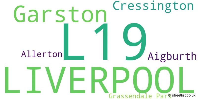
The largest settlement in the L19 postal code is LIVERPOOL followed by Garston, and Cressington.
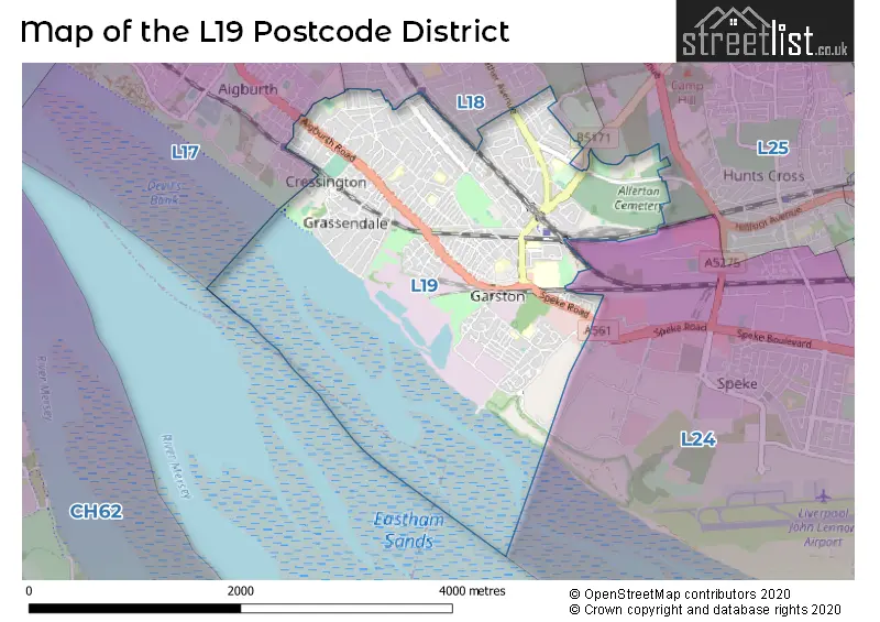
The postcode area has a boundary with Mersey.
The L19 Postcode shares a border with L24 (LIVERPOOL, Speke, Hale Village), L17 (LIVERPOOL, Aigburth, Sefton Park), L18 (LIVERPOOL, Mossley Hill, Allerton) and L25 (LIVERPOOL, Woolton, Hunts Cross).
In the L19 postcode district in Merseyside, the primary settlement is Liverpool, which has the highest count. Other significant settlements in the district include Aigburth, Cressington, and Garston. The post town for this district is Liverpool.
For the district L19, we have data on 10 postcode sectors. Here's a breakdown: The sector L19 0, covers Liverpool and Garston and Cressington in Merseyside. The sector L19 1, covers Liverpool and Garston in Merseyside. The sector L19 2, covers Liverpool and Garston in Merseyside. The sector L19 3, covers Liverpool in Merseyside. The sector L19 4, covers Liverpool in Merseyside. The sector L19 5, covers Liverpool and Allerton and Garston in Merseyside. The sector L19 6, covers Liverpool and Garston in Merseyside. The sector L19 7, covers Liverpool in Merseyside. The sector L19 8, covers Liverpool and Garston in Merseyside. The sector L19 9, covers Liverpool in Merseyside.

Map of the L19 Postcode District
Explore the L19 postcode district by using our free interactive map.
When it comes to local government, postal geography often disregards political borders. However, for a breakdown in the L19 District: the district mostly encompasses the Liverpool District (B) area with a total of 496 postcodes.
Recent House Sales in L19
| Date | Price | Address |
|---|---|---|
| 06/10/2023 | £95,000 | Bravery Court, Liverpool, L19 2QY |
| 29/09/2023 | £180,000 | King Street, Garston, Liverpool, L19 8EE |
| 13/09/2023 | £150,000 | Mcbride Street, Liverpool, L19 2ND |
| 06/09/2023 | £146,500 | Windfield Road, Liverpool, L19 8JN |
| 31/08/2023 | £146,000 | Basing Street, Liverpool, L19 1QS |
| 31/08/2023 | £350,000 | Lawrence Close, Liverpool, L19 3RW |
| 29/08/2023 | £85,000 | Canterbury Street, Garston, Liverpool, L19 8LQ |
| 29/08/2023 | £352,500 | Eastcote Road, Liverpool, L19 7NR |
| 18/08/2023 | £150,500 | The Spinnakers, Liverpool, L19 3RY |
| 18/08/2023 | £170,000 | Ivy Avenue, Liverpool, L19 9AH |
Weather Forecast for L19
Press Button to Show Forecast for Grassendale
| Time Period | Icon | Description | Temperature | Rain Probability | Wind |
|---|---|---|---|---|---|
| 03:00 to 06:00 | Partly cloudy (night) | 6.0°C (feels like 3.0°C) | 3.00% | ENE 7 mph | |
| 06:00 to 09:00 | Partly cloudy (day) | 5.0°C (feels like 2.0°C) | 2.00% | ENE 9 mph | |
| 09:00 to 12:00 | Cloudy | 8.0°C (feels like 6.0°C) | 5.00% | E 9 mph | |
| 12:00 to 15:00 | Overcast | 10.0°C (feels like 8.0°C) | 10.00% | ENE 9 mph | |
| 15:00 to 18:00 | Overcast | 10.0°C (feels like 8.0°C) | 46.00% | ENE 9 mph | |
| 18:00 to 21:00 | Light rain | 9.0°C (feels like 7.0°C) | 45.00% | NE 9 mph | |
| 21:00 to 00:00 | Cloudy | 8.0°C (feels like 6.0°C) | 5.00% | NE 7 mph |
Press Button to Show Forecast for Grassendale
| Time Period | Icon | Description | Temperature | Rain Probability | Wind |
|---|---|---|---|---|---|
| 00:00 to 03:00 | Cloudy | 7.0°C (feels like 4.0°C) | 4.00% | NE 7 mph | |
| 03:00 to 06:00 | Cloudy | 6.0°C (feels like 3.0°C) | 4.00% | N 9 mph | |
| 06:00 to 09:00 | Cloudy | 6.0°C (feels like 3.0°C) | 8.00% | N 9 mph | |
| 09:00 to 12:00 | Cloudy | 8.0°C (feels like 6.0°C) | 11.00% | NNW 9 mph | |
| 12:00 to 15:00 | Cloudy | 9.0°C (feels like 7.0°C) | 12.00% | NW 11 mph | |
| 15:00 to 18:00 | Partly cloudy (day) | 10.0°C (feels like 8.0°C) | 9.00% | WNW 13 mph | |
| 18:00 to 21:00 | Sunny day | 10.0°C (feels like 8.0°C) | 3.00% | W 11 mph | |
| 21:00 to 00:00 | Clear night | 8.0°C (feels like 6.0°C) | 2.00% | SW 11 mph |
Press Button to Show Forecast for Grassendale
| Time Period | Icon | Description | Temperature | Rain Probability | Wind |
|---|---|---|---|---|---|
| 00:00 to 03:00 | Clear night | 7.0°C (feels like 5.0°C) | 1.00% | SSW 9 mph | |
| 03:00 to 06:00 | Cloudy | 6.0°C (feels like 4.0°C) | 5.00% | SSE 11 mph | |
| 06:00 to 09:00 | Cloudy | 7.0°C (feels like 3.0°C) | 7.00% | SSE 13 mph | |
| 09:00 to 12:00 | Partly cloudy (day) | 10.0°C (feels like 7.0°C) | 2.00% | SSE 13 mph | |
| 12:00 to 15:00 | Overcast | 13.0°C (feels like 10.0°C) | 10.00% | S 16 mph | |
| 15:00 to 18:00 | Cloudy | 13.0°C (feels like 10.0°C) | 9.00% | S 16 mph | |
| 18:00 to 21:00 | Cloudy | 13.0°C (feels like 10.0°C) | 8.00% | SSE 16 mph | |
| 21:00 to 00:00 | Clear night | 11.0°C (feels like 8.0°C) | 3.00% | SSE 13 mph |
Press Button to Show Forecast for Grassendale
| Time Period | Icon | Description | Temperature | Rain Probability | Wind |
|---|---|---|---|---|---|
| 00:00 to 03:00 | Partly cloudy (night) | 10.0°C (feels like 7.0°C) | 4.00% | SE 13 mph | |
| 03:00 to 06:00 | Partly cloudy (night) | 9.0°C (feels like 6.0°C) | 4.00% | SE 13 mph | |
| 06:00 to 09:00 | Partly cloudy (day) | 9.0°C (feels like 6.0°C) | 4.00% | SE 13 mph | |
| 09:00 to 12:00 | Partly cloudy (day) | 12.0°C (feels like 9.0°C) | 4.00% | ESE 13 mph | |
| 12:00 to 15:00 | Partly cloudy (day) | 15.0°C (feels like 11.0°C) | 5.00% | SE 16 mph | |
| 15:00 to 18:00 | Cloudy | 16.0°C (feels like 13.0°C) | 14.00% | SE 13 mph | |
| 18:00 to 21:00 | Partly cloudy (day) | 15.0°C (feels like 13.0°C) | 6.00% | ESE 11 mph | |
| 21:00 to 00:00 | Cloudy | 13.0°C (feels like 11.0°C) | 8.00% | ESE 9 mph |
Where is the L19 Postcode District?
The L19 postcode district is located in Liverpool. It is situated near several towns such as Ellesmere Port to the south, Prescot to the northeast, Birkenhead to the west, Widnes to the east, Neston to the southwest, and Wallasey to the northwest. The distance from this postcode district to the center of London is approximately 173.37 miles.
The district is within the post town of LIVERPOOL.
The sector has postcodes within the nation of England.
The L19 Postcode District is in the Liverpool region of Merseyside within the North West (England).
Postcode Sectors within the L19 District
| Postcode Sector | Delivery Office |
|---|---|
| L19 0 | Garston Delivery Office |
| L19 1 | Garston Delivery Office |
| L19 2 | Garston Delivery Office |
| L19 3 | Garston Delivery Office |
| L19 4 | Garston Delivery Office |
| L19 5 | Garston Delivery Office |
| L19 6 | Garston Delivery Office |
| L19 7 | Garston Delivery Office |
| L19 8 | Garston Delivery Office |
| L19 9 | Garston Delivery Office |
| L | 1 | 9 | - | X | X | X |
| L | 1 | 9 | Space | Numeric | Letter | Letter |
Current Monthly Rental Prices
| # Bedrooms | Min Price | Max Price | Avg Price |
|---|---|---|---|
| 1 | £595 | £695 | £645 |
| 2 | £750 | £825 | £788 |
| 3 | £795 | £1,295 | £1,048 |
Current House Prices
| # Bedrooms | Min Price | Max Price | Avg Price |
|---|---|---|---|
| £220,000 | £220,000 | £220,000 | |
| 1 | £57,500 | £85,000 | £71,908 |
| 2 | £42,500 | £525,000 | £179,723 |
| 3 | £95,000 | £595,000 | £280,341 |
| 4 | £180,000 | £650,000 | £405,498 |
| 5 | £350,000 | £1,500,000 | £612,777 |
| 6 | £625,000 | £630,000 | £627,500 |
| 14 | £894,950 | £894,950 | £894,950 |
Estate Agents who Operate in the L19 District
| Logo | Name | Brand Name | Address | Contact Number | Total Properties |
|---|---|---|---|---|---|
 | Allerton | Entwistle Green | 18-20 Allerton Road, Mossley Hill, Liverpool, L18 1LN | 0151 453 3741 | 14 |
 | Allerton | Sutton Kersh | 38 Allerton Road Mossley Hill Liverpool L18 1LN | 0151 453 2272 | 14 |
 | Mossley Hill | Move Residential | 52/54 Allerton Road, Mossley Hill, Liverpool, L18 1LN | 0151 453 1497 | 13 |
 | Liverpool | Marshall Property | 372 Smithdown Road, Allerton, Liverpool, L15 5AN | 0151 453 2934 | 11 |
 | covering Liverpool | Purplebricks | Suite 7 First Floor Cranmore Drive Shirley Solihull B90 4RZ | 020 3907 2647 | 10 |
| Type of Property | 2018 Average | 2018 Sales | 2017 Average | 2017 Sales | 2016 Average | 2016 Sales | 2015 Average | 2015 Sales |
|---|---|---|---|---|---|---|---|---|
| Detached | £352,439 | 57 | £340,609 | 59 | £419,664 | 77 | £371,604 | 74 |
| Semi-Detached | £242,499 | 138 | £225,993 | 162 | £203,362 | 132 | £213,658 | 124 |
| Terraced | £141,544 | 166 | £135,302 | 170 | £132,074 | 179 | £128,329 | 135 |
| Flats | £98,686 | 39 | £104,752 | 83 | £120,231 | 56 | £92,833 | 38 |