The L19 8 postcode sector is within the county of Merseyside.
Did you know? According to the 2021 Census, the L19 8 postcode sector is home to a bustling 3,153 residents!
Given that each sector allows for 400 unique postcode combinations. Letters C, I, K, M, O and V are not allowed in the last two letters of a postcode. With 64 postcodes already in use, this leaves 336 units available.
The largest settlements in the L19 8 postal code are LIVERPOOL and Garston.
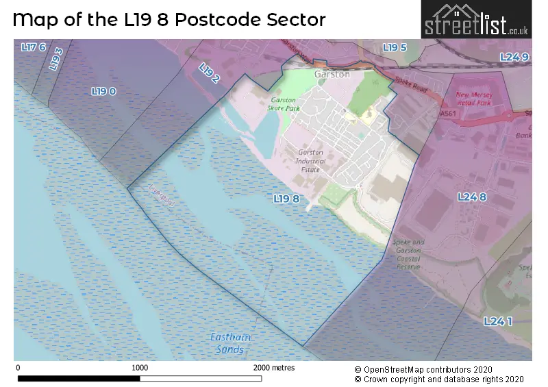
The L19 8 Postcode shares a border with L19 2 (LIVERPOOL, Garston) and L24 8 (Speke).
The sector is within the post town of LIVERPOOL.
L19 8 is a postcode sector within the L19 postcode district which is within the L Liverpool postcode area.
The Royal Mail delivery office for the L19 8 postal sector is the Garston Delivery Office.
The area of the L19 8 postcode sector is 0.58 square miles which is 1.50 square kilometres or 371.85 square acres.

Map of the L19 8 Postcode Sector
Explore the L19 8 postcode sector by using our free interactive map.
| L | 1 | 9 | - | 8 | X | X |
| L | 1 | 9 | Space | 8 | Letter | Letter |
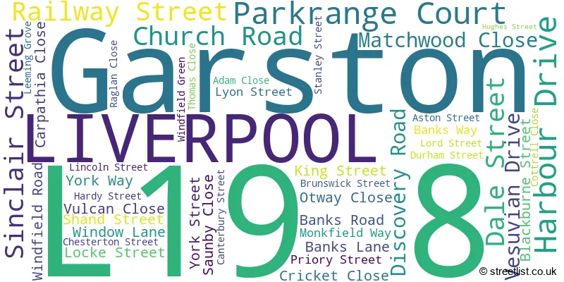
Official List of Streets
LIVERPOOL (26 Streets)
Garston (19 Streets)
Unofficial Streets or Alternative Spellings
Garston
SPEKE ROADLIVERPOOL
GARSTON WAY HORROCKS AVENUE LOGFIELD DRIVE VESTA ROADSpeke
DAKOTA DRIVE GARSTON SHORE ROAD DERBY STREET RAILWAY STREETWeather Forecast for L19 8
Press Button to Show Forecast for Grassendale
| Time Period | Icon | Description | Temperature | Rain Probability | Wind |
|---|---|---|---|---|---|
| 15:00 to 18:00 | Thunder shower (day) | 23.0°C (feels like 21.0°C) | 66.00% | SE 11 mph | |
| 18:00 to 21:00 | Heavy rain shower (day) | 19.0°C (feels like 19.0°C) | 55.00% | SSW 7 mph | |
| 21:00 to 00:00 | Cloudy | 17.0°C (feels like 17.0°C) | 9.00% | ESE 7 mph |
Press Button to Show Forecast for Grassendale
| Time Period | Icon | Description | Temperature | Rain Probability | Wind |
|---|---|---|---|---|---|
| 00:00 to 03:00 | Partly cloudy (night) | 16.0°C (feels like 16.0°C) | 24.00% | SW 4 mph | |
| 03:00 to 06:00 | Cloudy | 14.0°C (feels like 14.0°C) | 6.00% | W 4 mph | |
| 06:00 to 09:00 | Overcast | 14.0°C (feels like 13.0°C) | 9.00% | E 4 mph | |
| 09:00 to 12:00 | Cloudy | 16.0°C (feels like 14.0°C) | 5.00% | SSE 11 mph | |
| 12:00 to 15:00 | Cloudy | 19.0°C (feels like 16.0°C) | 5.00% | SSE 13 mph | |
| 15:00 to 18:00 | Cloudy | 20.0°C (feels like 17.0°C) | 6.00% | SSE 16 mph | |
| 18:00 to 21:00 | Cloudy | 18.0°C (feels like 15.0°C) | 10.00% | SSE 13 mph | |
| 21:00 to 00:00 | Cloudy | 16.0°C (feels like 14.0°C) | 21.00% | SE 13 mph |
Press Button to Show Forecast for Grassendale
| Time Period | Icon | Description | Temperature | Rain Probability | Wind |
|---|---|---|---|---|---|
| 00:00 to 03:00 | Light rain | 15.0°C (feels like 13.0°C) | 56.00% | SE 11 mph | |
| 03:00 to 06:00 | Heavy rain | 14.0°C (feels like 12.0°C) | 82.00% | ESE 11 mph | |
| 06:00 to 09:00 | Light rain | 14.0°C (feels like 12.0°C) | 57.00% | ESE 11 mph | |
| 09:00 to 12:00 | Heavy rain | 15.0°C (feels like 13.0°C) | 81.00% | ESE 11 mph | |
| 12:00 to 15:00 | Heavy rain | 16.0°C (feels like 14.0°C) | 85.00% | ESE 11 mph | |
| 15:00 to 18:00 | Light rain | 17.0°C (feels like 15.0°C) | 60.00% | SE 11 mph | |
| 18:00 to 21:00 | Light rain | 16.0°C (feels like 15.0°C) | 55.00% | S 9 mph | |
| 21:00 to 00:00 | Cloudy | 14.0°C (feels like 13.0°C) | 15.00% | SE 9 mph |
Press Button to Show Forecast for Grassendale
| Time Period | Icon | Description | Temperature | Rain Probability | Wind |
|---|---|---|---|---|---|
| 00:00 to 03:00 | Cloudy | 13.0°C (feels like 11.0°C) | 7.00% | ESE 9 mph | |
| 03:00 to 06:00 | Partly cloudy (night) | 12.0°C (feels like 10.0°C) | 3.00% | ESE 9 mph | |
| 06:00 to 09:00 | Sunny day | 13.0°C (feels like 11.0°C) | 2.00% | ESE 9 mph | |
| 09:00 to 12:00 | Cloudy | 16.0°C (feels like 14.0°C) | 8.00% | SE 11 mph | |
| 12:00 to 15:00 | Light rain shower (day) | 18.0°C (feels like 16.0°C) | 32.00% | SE 9 mph | |
| 15:00 to 18:00 | Partly cloudy (day) | 19.0°C (feels like 17.0°C) | 14.00% | SE 9 mph | |
| 18:00 to 21:00 | Sunny day | 17.0°C (feels like 16.0°C) | 11.00% | ESE 7 mph | |
| 21:00 to 00:00 | Clear night | 15.0°C (feels like 14.0°C) | 6.00% | SSE 7 mph |
Press Button to Show Forecast for Grassendale
| Time Period | Icon | Description | Temperature | Rain Probability | Wind |
|---|---|---|---|---|---|
| 00:00 to 03:00 | Clear night | 13.0°C (feels like 12.0°C) | 1.00% | SE 7 mph | |
| 03:00 to 06:00 | Clear night | 12.0°C (feels like 11.0°C) | 2.00% | SE 4 mph | |
| 06:00 to 09:00 | Sunny day | 13.0°C (feels like 12.0°C) | 2.00% | SE 7 mph | |
| 09:00 to 12:00 | Sunny day | 16.0°C (feels like 16.0°C) | 3.00% | S 4 mph | |
| 12:00 to 15:00 | Cloudy | 18.0°C (feels like 18.0°C) | 10.00% | W 7 mph | |
| 15:00 to 18:00 | Cloudy | 18.0°C (feels like 17.0°C) | 14.00% | NW 7 mph | |
| 18:00 to 21:00 | Light rain shower (day) | 16.0°C (feels like 15.0°C) | 30.00% | NNW 7 mph | |
| 21:00 to 00:00 | Light rain shower (night) | 14.0°C (feels like 13.0°C) | 29.00% | WNW 7 mph |
Schools and Places of Education Within the L19 8 Postcode Sector
Banks Road Primary School
Community school
Banks Road, Liverpool, Merseyside, L19 8JZ
Head: Mr Jamie Wilson
Ofsted Rating: Good
Inspection: 2023-06-15 (332 days ago)
Website: Visit Banks Road Primary School Website
Phone: 01514274360
Number of Pupils: 323
Holy Trinity Catholic Primary School
Voluntary aided school
Banks Road, Liverpool, Merseyside, L19 8JY
Head: Mrs Helen Raley-Williams
Ofsted Rating: Good
Inspection: 2023-02-03 (464 days ago)
Website: Visit Holy Trinity Catholic Primary School Website
Phone: 01514277466
Number of Pupils: 218
House Prices in the L19 8 Postcode Sector
| Type of Property | 2018 Average | 2018 Sales | 2017 Average | 2017 Sales | 2016 Average | 2016 Sales | 2015 Average | 2015 Sales |
|---|---|---|---|---|---|---|---|---|
| Detached | £233,333 | 3 | £182,500 | 2 | £0 | 0 | £0 | 0 |
| Semi-Detached | £127,667 | 3 | £105,500 | 5 | £161,250 | 22 | £154,249 | 8 |
| Terraced | £108,717 | 32 | £98,502 | 29 | £108,936 | 35 | £122,835 | 25 |
| Flats | £0 | 0 | £175,000 | 2 | £0 | 0 | £0 | 0 |
Important Postcodes L19 8 in the Postcode Sector
L19 8JY is the postcode for Holy Trinity Primary School, Banks Road
L19 8JZ is the postcode for Garston Childrens Centre, Banks Road, and Banks Road Cp School, Banks Road
| The L19 8 Sector is within these Local Authorities |
|
|---|---|
| The L19 8 Sector is within these Counties |
|
| The L19 8 Sector is within these Water Company Areas |
|