The L18 postcode district is a postal district located in the L Liverpool postcode area with a population of 26,123 residents according to the 2021 England and Wales Census.
The area of the L18 postcode district is 2.58 square miles which is 6.69 square kilometres or 1,653.88 acres.
Currently, the L18 district has about 558 postcode units spread across 10 geographic postcode sectors.
Given that each sector allows for 400 unique postcode combinations, the district has a capacity of 4,000 postcodes. With 558 postcodes already in use, this leaves 3442 units available.
The largest settlement in the L18 postal code is LIVERPOOL followed by Mossley Hill, and Allerton.
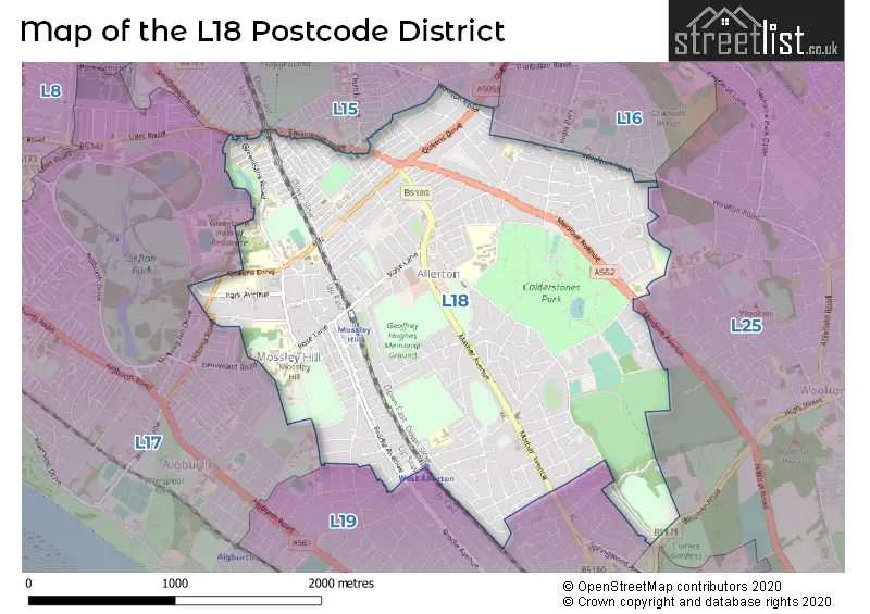
The L18 Postcode shares a border with L19 (LIVERPOOL, Garston, Cressington), L17 (LIVERPOOL, Aigburth, Sefton Park), L15 (LIVERPOOL, Wavertree), L16 (LIVERPOOL, Childwall) and L25 (LIVERPOOL, Woolton, Hunts Cross).
The primary settlement in the L18 postcode district is Mossley Hill, located in Liverpool, Merseyside. Other significant settlements include Allerton. The county is Merseyside, which is situated in England. The post town with the highest postcode count is Liverpool.
For the district L18, we have data on 10 postcode sectors. Here's a breakdown: The sector L18 0, covers Liverpool and Mossley Hill in Merseyside. The sector L18 1, covers Liverpool and Mossley Hill in Merseyside. The sector L18 2, covers Liverpool and Mossley Hill in Merseyside. The sector L18 3, covers Liverpool in Merseyside. The sector L18 4, covers Liverpool in Merseyside. The sector L18 5, covers Liverpool in Merseyside. The sector L18 6, covers Liverpool and Mossley Hill in Merseyside. The sector L18 7, covers Liverpool and Mossley Hill in Merseyside. The sector L18 8, covers Liverpool and Mossley Hill in Merseyside. The sector L18 9, covers Liverpool and Allerton in Merseyside.


Map of the L18 Postcode District
Explore the L18 postcode district by using our free interactive map.
When it comes to local government, postal geography often disregards political borders. However, for a breakdown in the L18 District: the district mostly encompasses the Liverpool District (B) area with a total of 555 postcodes.
Recent House Sales in L18
| Date | Price | Address |
|---|---|---|
| 27/10/2023 | £428,000 | Lyndon Drive, Liverpool, L18 6HP |
| 02/10/2023 | £175,500 | Elmsley Court, Liverpool, L18 8BA |
| 19/09/2023 | £566,000 | Beechfield Road, Liverpool, L18 3EQ |
| 19/09/2023 | £585,000 | Hornby Lane, Liverpool, L18 3HH |
| 15/09/2023 | £470,000 | Henley Road, Liverpool, L18 2DN |
| 08/09/2023 | £278,500 | Karslake Road, Liverpool, L18 1EY |
| 01/09/2023 | £270,000 | Nicander Road, Liverpool, L18 1HY |
| 01/09/2023 | £425,000 | Glenmore Avenue, Mossley Hill, Liverpool, L18 4QF |
| 31/08/2023 | £287,406 | Erylmore Road, Liverpool, L18 4QS |
| 29/08/2023 | £525,000 | Mentmore Road, Mossley Hill, Liverpool, L18 4PU |
Weather Forecast for L18
Press Button to Show Forecast for Allerton (Merseyside)
| Time Period | Icon | Description | Temperature | Rain Probability | Wind |
|---|---|---|---|---|---|
| 18:00 to 21:00 | Cloudy | 9.0°C (feels like 7.0°C) | 7.00% | ENE 9 mph | |
| 21:00 to 00:00 | Cloudy | 8.0°C (feels like 6.0°C) | 5.00% | ENE 9 mph |
Press Button to Show Forecast for Allerton (Merseyside)
| Time Period | Icon | Description | Temperature | Rain Probability | Wind |
|---|---|---|---|---|---|
| 00:00 to 03:00 | Cloudy | 7.0°C (feels like 4.0°C) | 6.00% | NNE 9 mph | |
| 03:00 to 06:00 | Overcast | 6.0°C (feels like 3.0°C) | 49.00% | N 9 mph | |
| 06:00 to 09:00 | Light rain | 6.0°C (feels like 3.0°C) | 57.00% | NNW 9 mph | |
| 09:00 to 12:00 | Light rain | 7.0°C (feels like 3.0°C) | 59.00% | NNW 11 mph | |
| 12:00 to 15:00 | Light rain | 8.0°C (feels like 4.0°C) | 55.00% | NW 13 mph | |
| 15:00 to 18:00 | Cloudy | 10.0°C (feels like 6.0°C) | 51.00% | WNW 16 mph | |
| 18:00 to 21:00 | Partly cloudy (day) | 10.0°C (feels like 7.0°C) | 4.00% | W 13 mph | |
| 21:00 to 00:00 | Partly cloudy (night) | 8.0°C (feels like 6.0°C) | 1.00% | SW 11 mph |
Press Button to Show Forecast for Allerton (Merseyside)
| Time Period | Icon | Description | Temperature | Rain Probability | Wind |
|---|---|---|---|---|---|
| 00:00 to 03:00 | Partly cloudy (night) | 7.0°C (feels like 4.0°C) | 7.00% | S 9 mph | |
| 03:00 to 06:00 | Cloudy | 6.0°C (feels like 3.0°C) | 18.00% | SSE 11 mph | |
| 06:00 to 09:00 | Partly cloudy (day) | 7.0°C (feels like 4.0°C) | 2.00% | SSE 11 mph | |
| 09:00 to 12:00 | Cloudy | 11.0°C (feels like 8.0°C) | 9.00% | S 16 mph | |
| 12:00 to 15:00 | Cloudy | 13.0°C (feels like 10.0°C) | 14.00% | S 16 mph | |
| 15:00 to 18:00 | Cloudy | 13.0°C (feels like 10.0°C) | 16.00% | S 18 mph | |
| 18:00 to 21:00 | Cloudy | 13.0°C (feels like 10.0°C) | 12.00% | SSE 16 mph | |
| 21:00 to 00:00 | Cloudy | 11.0°C (feels like 8.0°C) | 5.00% | SSE 16 mph |
Press Button to Show Forecast for Allerton (Merseyside)
| Time Period | Icon | Description | Temperature | Rain Probability | Wind |
|---|---|---|---|---|---|
| 00:00 to 03:00 | Cloudy | 10.0°C (feels like 7.0°C) | 5.00% | SSE 13 mph | |
| 03:00 to 06:00 | Partly cloudy (night) | 9.0°C (feels like 6.0°C) | 2.00% | SE 13 mph | |
| 06:00 to 09:00 | Partly cloudy (day) | 9.0°C (feels like 6.0°C) | 2.00% | SE 13 mph | |
| 09:00 to 12:00 | Partly cloudy (day) | 12.0°C (feels like 9.0°C) | 2.00% | SE 16 mph | |
| 12:00 to 15:00 | Cloudy | 16.0°C (feels like 12.0°C) | 7.00% | SE 16 mph | |
| 15:00 to 18:00 | Cloudy | 16.0°C (feels like 13.0°C) | 9.00% | SE 16 mph | |
| 18:00 to 21:00 | Cloudy | 15.0°C (feels like 13.0°C) | 10.00% | SE 11 mph | |
| 21:00 to 00:00 | Partly cloudy (night) | 13.0°C (feels like 11.0°C) | 5.00% | ESE 9 mph |
Press Button to Show Forecast for Allerton (Merseyside)
| Time Period | Icon | Description | Temperature | Rain Probability | Wind |
|---|---|---|---|---|---|
| 00:00 to 03:00 | Partly cloudy (night) | 12.0°C (feels like 10.0°C) | 5.00% | ESE 9 mph | |
| 03:00 to 06:00 | Cloudy | 11.0°C (feels like 9.0°C) | 9.00% | E 7 mph | |
| 06:00 to 09:00 | Cloudy | 11.0°C (feels like 10.0°C) | 14.00% | E 7 mph | |
| 09:00 to 12:00 | Cloudy | 13.0°C (feels like 12.0°C) | 15.00% | E 7 mph | |
| 12:00 to 15:00 | Light rain shower (day) | 16.0°C (feels like 14.0°C) | 36.00% | E 7 mph | |
| 15:00 to 18:00 | Cloudy | 17.0°C (feels like 16.0°C) | 20.00% | ENE 7 mph | |
| 18:00 to 21:00 | Cloudy | 16.0°C (feels like 15.0°C) | 14.00% | ESE 7 mph | |
| 21:00 to 00:00 | Cloudy | 14.0°C (feels like 12.0°C) | 11.00% | ESE 7 mph |
Where is the L18 Postcode District?
The postcode district of L18 is located in the town of Liverpool. It is in close proximity to several nearby towns, including Prescot to the North East, Birkenhead to the West, Ellesmere Port to the South, Widnes to the East, Wallasey to the North West, and Neston to the South West. Additionally, L18 is approximately 174.6 miles away from the center of London.
The district is within the post town of LIVERPOOL.
The sector has postcodes within the nation of England.
The L18 Postcode District is in the Liverpool region of Merseyside within the North West (England).
Postcode Sectors within the L18 District
| Postcode Sector | Delivery Office |
|---|---|
| L18 0 | Mossley Hill Delivery Office |
| L18 1 | Mossley Hill Delivery Office |
| L18 2 | Mossley Hill Delivery Office |
| L18 3 | Mossley Hill Delivery Office |
| L18 4 | Mossley Hill Delivery Office |
| L18 5 | Mossley Hill Delivery Office |
| L18 6 | Mossley Hill Delivery Office |
| L18 7 | Mossley Hill Delivery Office |
| L18 8 | Mossley Hill Delivery Office |
| L18 9 | Mossley Hill Delivery Office |
| L | 1 | 8 | - | X | X | X |
| L | 1 | 8 | Space | Numeric | Letter | Letter |
Tourist Attractions within the Postcode Area
We found 1 visitor attractions within the L18 postcode area
| Sudley House |
|---|
| Historic Properties |
| Historic House / House and Garden / Palace |
| View Sudley House on Google Maps |
Current Monthly Rental Prices
| # Bedrooms | Min Price | Max Price | Avg Price |
|---|---|---|---|
| 1 | £373 | £500 | £436 |
| 2 | £455 | £1,700 | £1,201 |
| 3 | £412 | £2,500 | £1,368 |
| 4 | £520 | £1,495 | £1,105 |
| 5 | £95 | £520 | £371 |
| 6 | £2,400 | £2,400 | £2,400 |
| 7 | £412 | £455 | £431 |
Current House Prices
| # Bedrooms | Min Price | Max Price | Avg Price |
|---|---|---|---|
| £800,000 | £800,000 | £800,000 | |
| 1 | £110,000 | £206,400 | £164,413 |
| 2 | £119,000 | £650,000 | £274,975 |
| 3 | £190,000 | £925,000 | £359,351 |
| 4 | £240,000 | £975,000 | £529,129 |
| 5 | £330,000 | £1,500,000 | £650,455 |
| 6 | £450,000 | £990,000 | £671,250 |
Estate Agents who Operate in the L18 District
| Logo | Name | Brand Name | Address | Contact Number | Total Properties |
|---|---|---|---|---|---|
 | Mossley Hill | Move Residential | 52/54 Allerton Road, Mossley Hill, Liverpool, L18 1LN | 0151 453 1497 | 40 |
 | Allerton | Sutton Kersh | 38 Allerton Road Mossley Hill Liverpool L18 1LN | 0151 453 2272 | 22 |
 | Liverpool | Venmore | 8/10 Allerton Road, Mossley Hill, Liverpool, L18 1LN | 0151 453 6513 | 17 |
 | Liverpool | Atlas Estate Agents | 2 Allerton Road Mossley Hill Liverpool L18 1LN | 0151 453 6186 | 16 |
 | Liverpool | Find Your Eden Limited | Liverpool | 0151 312 8288 | 16 |
| Type of Property | 2018 Average | 2018 Sales | 2017 Average | 2017 Sales | 2016 Average | 2016 Sales | 2015 Average | 2015 Sales |
|---|---|---|---|---|---|---|---|---|
| Detached | £521,411 | 45 | £496,048 | 55 | £463,161 | 49 | £495,623 | 70 |
| Semi-Detached | £313,439 | 156 | £307,453 | 182 | £279,842 | 136 | £283,976 | 142 |
| Terraced | £201,823 | 192 | £192,336 | 195 | £183,152 | 169 | £191,065 | 192 |
| Flats | £226,141 | 64 | £182,122 | 62 | £171,645 | 82 | £162,762 | 71 |