The L25 2 postcode sector is within the county of Merseyside.
Did you know? According to the 2021 Census, the L25 2 postcode sector is home to a bustling 3,977 residents!
Given that each sector allows for 400 unique postcode combinations. Letters C, I, K, M, O and V are not allowed in the last two letters of a postcode. With 108 postcodes already in use, this leaves 292 units available.
The largest settlements in the L25 2 postal code are LIVERPOOL and Belle Vale.
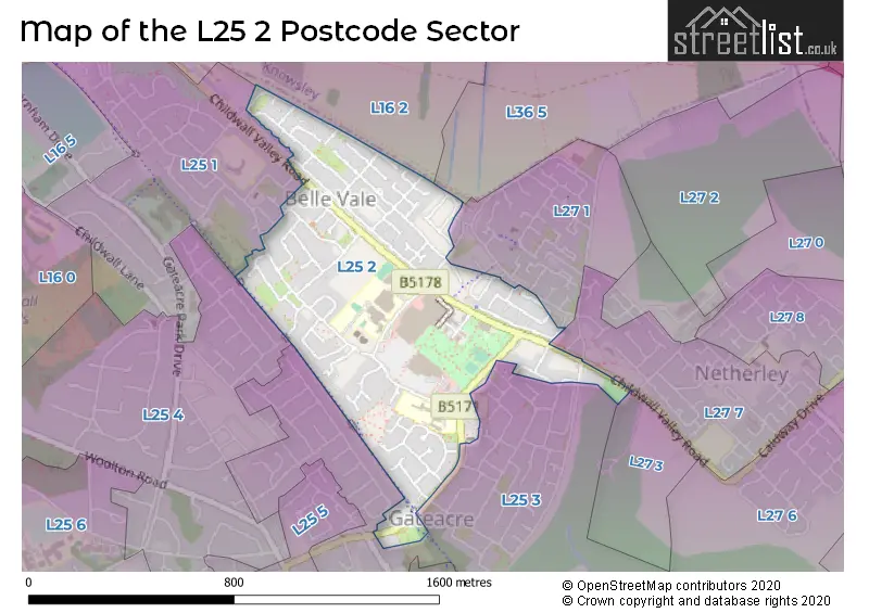
The L25 2 Postcode shares a border with L16 2 (LIVERPOOL, Broadgreen), L25 1 (LIVERPOOL, Childwall), L25 3 (LIVERPOOL, Woolton, Gateacre), L25 4 (LIVERPOOL, Woolton, Gateacre), L27 7 (LIVERPOOL, Netherley), L27 1 (LIVERPOOL), L27 3 (LIVERPOOL) and L36 5 (LIVERPOOL, Huyton).
The sector is within the post town of LIVERPOOL.
L25 2 is a postcode sector within the L25 postcode district which is within the L Liverpool postcode area.
The Royal Mail delivery office for the L25 2 postal sector is the Woolton Delivery Office.
The area of the L25 2 postcode sector is 0.39 square miles which is 1.02 square kilometres or 252.79 square acres.

Map of the L25 2 Postcode Sector
Explore the L25 2 postcode sector by using our free interactive map.
| L | 2 | 5 | - | 2 | X | X |
| L | 2 | 5 | Space | 2 | Letter | Letter |
Official List of Streets
LIVERPOOL (65 Streets)
Belle Vale (2 Streets)
Unofficial Streets or Alternative Spellings
Schools and Places of Education Within the L25 2 Postcode Sector
Belle Vale Community Primary School
Community school
Besford Road, Liverpool, Merseyside, L25 2QF
Head: Mrs Ruth Lancaster
Ofsted Rating: Good
Inspection: 2023-09-27 (239 days ago)
Website: Visit Belle Vale Community Primary School Website
Phone: 01514878571
Number of Pupils: 279
Gateacre School
Community school
Hedgefield Road, Liverpool, Merseyside, L25 2RW
Head: Mr Phil LLoyd
Ofsted Rating: Requires improvement
Inspection: 2023-12-06 (169 days ago)
Website: Visit Gateacre School Website
Phone: 01513631111
Number of Pupils: 1161
Hope School
Community special school
251 Hartsbourne Avenue, Liverpool, Merseyside, L25 2RY
Head: Mrs Maxine O'Neill
Ofsted Rating: Outstanding
Inspection: 2019-04-02 (1878 days ago)
Website: Visit Hope School Website
Phone: 01513633130
Number of Pupils: 59
Our Lady of the Assumption Catholic Primary School
Voluntary aided school
Hedgefield Road, Liverpool, Merseyside, L25 2RW
Head: Mr Martin Burke
Ofsted Rating: Good
Inspection: 2018-11-07 (2024 days ago)
Website: Visit Our Lady of the Assumption Catholic Primary School Website
Phone: 01514879301
Number of Pupils: 230
House Prices in the L25 2 Postcode Sector
| Type of Property | 2018 Average | 2018 Sales | 2017 Average | 2017 Sales | 2016 Average | 2016 Sales | 2015 Average | 2015 Sales |
|---|---|---|---|---|---|---|---|---|
| Detached | £170,778 | 9 | £170,000 | 1 | £155,000 | 1 | £149,167 | 3 |
| Semi-Detached | £157,993 | 7 | £100,667 | 3 | £118,438 | 8 | £148,346 | 13 |
| Terraced | £100,423 | 13 | £123,572 | 9 | £97,972 | 18 | £88,267 | 21 |
| Flats | £76,813 | 4 | £66,125 | 4 | £90,625 | 4 | £0 | 0 |
Important Postcodes L25 2 in the Postcode Sector
L25 2PL is the postcode for Merseyside Police, Police Station, Childwall Valley Road
L25 2PY is the postcode for Belle Vale Community Fire Station, Merseyside Fire and Rescue Service
L25 2QF is the postcode for BELLE VALE COMMUNITY PRIMARY SCHOOL, BESFORD ROAD, LIVERPOOL, and Belle Vale Community Primary School, Besford Road
L25 2RW is the postcode for Our Lady of the Assumption Primary School, Hedgefield Road, SPORTS BARN, Gateacre School, 8 Hedgefield Road, and Gateacre Comprehensive School, 8 Hedgefield Road
L25 2RY is the postcode for Hope School, 251 Hartsbourne Avenue
L25 2UF is the postcode for Jobcentre Plus, 302, Childwall Valley Road
L25 2XE is the postcode for Belle Vale Neighbourhood Health Centre, Hedgefield Road
| The L25 2 Sector is within these Local Authorities |
|
|---|---|
| The L25 2 Sector is within these Counties |
|
| The L25 2 Sector is within these Water Company Areas |
|