The L25 8 postcode sector is within the county of Merseyside.
Did you know? According to the 2021 Census, the L25 8 postcode sector is home to a bustling 3,411 residents!
Given that each sector allows for 400 unique postcode combinations. Letters C, I, K, M, O and V are not allowed in the last two letters of a postcode. With 76 postcodes already in use, this leaves 324 units available.
The largest settlements in the L25 8 postal code are LIVERPOOL and Woolton.
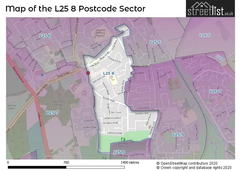
The L25 8 Postcode shares a border with L25 0 (LIVERPOOL, Hunts Cross, Woolton), L25 5 (LIVERPOOL, Woolton, Gateacre), L25 7 (Woolton, LIVERPOOL) and L25 9 (LIVERPOOL, Hunts Cross, Woolton).
The sector is within the post town of LIVERPOOL.
L25 8 is a postcode sector within the L25 postcode district which is within the L Liverpool postcode area.
The Royal Mail delivery office for the L25 8 postal sector is the Woolton Delivery Office.
The area of the L25 8 postcode sector is 0.25 square miles which is 0.65 square kilometres or 161.16 square acres.

Map of the L25 8 Postcode Sector
Explore the L25 8 postcode sector by using our free interactive map.
| L | 2 | 5 | - | 8 | X | X |
| L | 2 | 5 | Space | 8 | Letter | Letter |
Official List of Streets
LIVERPOOL (36 Streets)
Unofficial Streets or Alternative Spellings
Schools and Places of Education Within the L25 8 Postcode Sector
Much Woolton Catholic Primary School
Voluntary aided school
Watergate Lane, Liverpool, Merseyside, L25 8QH
Head: Mr Matthew White
Ofsted Rating: Good
Inspection: 2020-02-12 (1562 days ago)
Website: Visit Much Woolton Catholic Primary School Website
Phone: 01514286114
Number of Pupils: 417
House Prices in the L25 8 Postcode Sector
| Type of Property | 2018 Average | 2018 Sales | 2017 Average | 2017 Sales | 2016 Average | 2016 Sales | 2015 Average | 2015 Sales |
|---|---|---|---|---|---|---|---|---|
| Detached | £365,000 | 2 | £360,567 | 14 | £332,711 | 7 | £211,000 | 2 |
| Semi-Detached | £208,562 | 42 | £209,274 | 50 | £196,695 | 46 | £176,271 | 45 |
| Terraced | £206,292 | 12 | £193,313 | 8 | £174,000 | 5 | £158,545 | 11 |
| Flats | £65,000 | 5 | £69,667 | 3 | £65,500 | 4 | £96,665 | 3 |
Important Postcodes L25 8 in the Postcode Sector
L25 8QH is the postcode for Much Woolton Catholic Primary School, Watergate Lane
| The L25 8 Sector is within these Local Authorities |
|
|---|---|
| The L25 8 Sector is within these Counties |
|
| The L25 8 Sector is within these Water Company Areas |
|