The L28 7 postcode sector is within the county of Merseyside.
Did you know? According to the 2021 Census, the L28 7 postcode sector is home to a bustling 555 residents!
Given that each sector allows for 400 unique postcode combinations. Letters C, I, K, M, O and V are not allowed in the last two letters of a postcode. With 10 postcodes already in use, this leaves 390 units available.
The largest settlements in the L28 7 postal code are LIVERPOOL and Stockbridge Village.
The L28 7 Postcode shares a border with L28 5 (LIVERPOOL, Stockbridge Village), L28 6 (LIVERPOOL), L28 1 (LIVERPOOL, Stockbridge Village), L28 3 (LIVERPOOL) and L28 0 (LIVERPOOL).
The sector is within the post town of LIVERPOOL.
L28 7 is a postcode sector within the L28 postcode district which is within the L Liverpool postcode area.
The Royal Mail delivery office for the L28 7 postal sector is the West Derby Delivery Office.
The area of the L28 7 postcode sector is 0.05 square miles which is 0.12 square kilometres or 29.14 square acres.

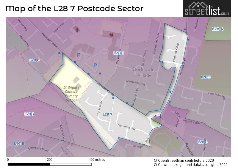
Map of the L28 7 Postcode Sector
Explore the L28 7 postcode sector by using our free interactive map.
| L | 2 | 8 | - | 7 | X | X |
| L | 2 | 8 | Space | 7 | Letter | Letter |
Official List of Streets
Stockbridge Village (4 Streets)
LIVERPOOL (3 Streets)
Unofficial Streets or Alternative Spellings
Stockbridge Village
HASWELL DRIVELIVERPOOL
BRANDEARTH HEY BUCKTHORN CLOSE GREENVALLEY ROAD MILLBROOK WAY QUICKTHORN CRESCENT THE WITHENS WHITETHORN DRIVE LEACH CROFTSchools and Places of Education Within the L28 7 Postcode Sector
St Brigid's Catholic Primary School
Voluntary aided school
Waterpark Drive, Liverpool, Merseyside, L28 7RE
Head: Mrs Rachael Tyler
Ofsted Rating: Good
Inspection: 2019-09-26 (1711 days ago)
Website: Visit St Brigid's Catholic Primary School Website
Phone: 01514778150
Number of Pupils: 257
House Prices in the L28 7 Postcode Sector
| Type of Property | 2018 Average | 2018 Sales | 2017 Average | 2017 Sales | 2016 Average | 2016 Sales | 2015 Average | 2015 Sales |
|---|---|---|---|---|---|---|---|---|
| Detached | £0 | 0 | £0 | 0 | £0 | 0 | £0 | 0 |
| Semi-Detached | £0 | 0 | £72,500 | 1 | £0 | 0 | £0 | 0 |
| Terraced | £75,625 | 4 | £77,500 | 3 | £60,000 | 1 | £56,000 | 1 |
| Flats | £0 | 0 | £0 | 0 | £0 | 0 | £0 | 0 |
Important Postcodes L28 7 in the Postcode Sector
L28 7RE is the postcode for St. Brigids Primary School, Waterpark Drive, and SPORTS AND ARTS BUILDING, St. Brigids Primary School, Waterpark Drive
| The L28 7 Sector is within these Local Authorities |
|
|---|---|
| The L28 7 Sector is within these Counties |
|
| The L28 7 Sector is within these Water Company Areas |
|