The L28 8 postcode sector is within the county of Merseyside.
Did you know? According to the 2021 Census, the L28 8 postcode sector is home to a bustling 482 residents!
Given that each sector allows for 400 unique postcode combinations. Letters C, I, K, M, O and V are not allowed in the last two letters of a postcode. With 8 postcodes already in use, this leaves 392 units available.
The L28 8 postal code covers the settlement of LIVERPOOL.
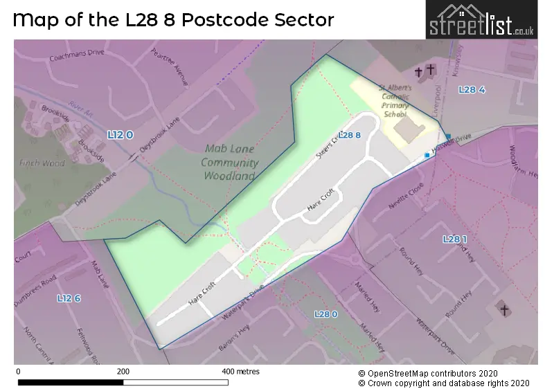
The L28 8 Postcode shares a border with L28 4 (LIVERPOOL), L28 1 (LIVERPOOL, Stockbridge Village), L12 6 (LIVERPOOL), L12 0 (LIVERPOOL, West Derby) and L28 0 (LIVERPOOL).
The sector is within the post town of LIVERPOOL.
L28 8 is a postcode sector within the L28 postcode district which is within the L Liverpool postcode area.
The Royal Mail delivery office for the L28 8 postal sector is the West Derby Delivery Office.
The area of the L28 8 postcode sector is 0.05 square miles which is 0.13 square kilometres or 32.59 square acres.


Map of the L28 8 Postcode Sector
Explore the L28 8 postcode sector by using our free interactive map.
| L | 2 | 8 | - | 8 | X | X |
| L | 2 | 8 | Space | 8 | Letter | Letter |
Official List of Streets
LIVERPOOL (2 Streets)
Unofficial Streets or Alternative Spellings
Schools and Places of Education Within the L28 8 Postcode Sector
St Albert's Catholic Primary School
Voluntary aided school
Steers Croft, Liverpool, Merseyside, L28 8AJ
Head: Mrs L McEvoy
Ofsted Rating: Good
Inspection: 2021-11-11 (934 days ago)
Website: Visit St Albert's Catholic Primary School Website
Phone: 01514778560
Number of Pupils: 233
House Prices in the L28 8 Postcode Sector
| Type of Property | 2018 Average | 2018 Sales | 2017 Average | 2017 Sales | 2016 Average | 2016 Sales | 2015 Average | 2015 Sales |
|---|---|---|---|---|---|---|---|---|
| Detached | £0 | 0 | £0 | 0 | £0 | 0 | £0 | 0 |
| Semi-Detached | £0 | 0 | £0 | 0 | £0 | 0 | £0 | 0 |
| Terraced | £64,800 | 5 | £50,000 | 1 | £56,500 | 4 | £45,000 | 1 |
| Flats | £0 | 0 | £0 | 0 | £0 | 0 | £0 | 0 |
Important Postcodes L28 8 in the Postcode Sector
L28 8AJ is the postcode for St. Alberts Primary School, Steers Croft
| The L28 8 Sector is within these Local Authorities |
|
|---|---|
| The L28 8 Sector is within these Counties |
|
| The L28 8 Sector is within these Water Company Areas |
|