The L31 6 postcode sector is within the county of Merseyside.
Did you know? According to the 2021 Census, the L31 6 postcode sector is home to a bustling 3,106 residents!
Given that each sector allows for 400 unique postcode combinations. Letters C, I, K, M, O and V are not allowed in the last two letters of a postcode. With 70 postcodes already in use, this leaves 330 units available.
The largest settlements in the L31 6 postal code are LIVERPOOL and Maghull.
The L31 6 Postcode shares a border with L31 1 (Melling, Maghull, LIVERPOOL), L31 0 (LIVERPOOL, Maghull, Lydiate), L31 2 (LIVERPOOL, Lydiate, Maghull), L31 3 (LIVERPOOL, Maghull), L31 9 (LIVERPOOL, Maghull) and L31 7 (LIVERPOOL, Maghull).
The sector is within the post town of LIVERPOOL.
L31 6 is a postcode sector within the L3 postcode district which is within the L Liverpool postcode area.
The Royal Mail delivery office for the L31 6 postal sector is the Liverpool 1-3.
The area of the L31 6 postcode sector is 0.31 square miles which is 0.79 square kilometres or 195.76 square acres.
Waterways within the L31 6 postcode sector include the Leeds and Liverpool Canal.

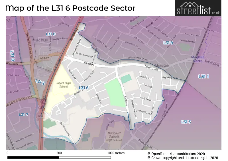
Map of the L31 6 Postcode Sector
Explore the L31 6 postcode sector by using our free interactive map.
| L | 3 | 1 | - | 6 | X | X |
| L | 3 | 1 | Space | 6 | Letter | Letter |
Official List of Streets
LIVERPOOL (31 Streets)
Maghull (15 Streets)
Unofficial Streets or Alternative Spellings
Schools and Places of Education Within the L31 6 Postcode Sector
Deyes High School
Academy converter
Deyes Lane, Liverpool, Merseyside, L31 6DE
Head: Mrs Victoria Beaney
Ofsted Rating: Good
Inspection: 2019-03-14 (1902 days ago)
Website: Visit Deyes High School Website
Phone: 01515263814
Number of Pupils: 1390
St Andrews Church of England Primary School, Maghull
Academy converter
Deyes Lane, Liverpool, Merseyside, L31 6DE
Head: Mr Simon Jones
Ofsted Rating: Good
Inspection: 2022-10-12 (594 days ago)
Website: Visit St Andrews Church of England Primary School, Maghull Website
Phone: 01515261378
Number of Pupils: 251
House Prices in the L31 6 Postcode Sector
| Type of Property | 2018 Average | 2018 Sales | 2017 Average | 2017 Sales | 2016 Average | 2016 Sales | 2015 Average | 2015 Sales |
|---|---|---|---|---|---|---|---|---|
| Detached | £295,300 | 5 | £215,286 | 7 | £190,000 | 1 | £180,800 | 5 |
| Semi-Detached | £184,000 | 25 | £158,979 | 24 | £162,120 | 20 | £165,007 | 21 |
| Terraced | £158,968 | 16 | £151,768 | 10 | £152,925 | 14 | £132,192 | 13 |
| Flats | £106,600 | 5 | £121,813 | 8 | £127,375 | 8 | £112,250 | 4 |
Important Postcodes L31 6 in the Postcode Sector
L31 6DE is the postcode for JUNIOR BLOCK, St. Andrews Maghull C of E Primary School, Deyes Lane, SCIENCE, MATHS, LANGUAGES, Deyes Academy, Deyes Lane, SEFTON BUILDING - SCIENCE AND GEOGRAPHY, Deyes Academy, Deyes Lane, SIXTH FORM COLLEGE, Deyes Academy, Deyes Lane, St. Andrews Maghull C of E Primary School, Deyes Lane, MAIN SCHOOL BUILDING, Deyes Academy, Deyes Lane, INFANT BLOCK, St. Andrews Maghull C of E Primary School, Deyes Lane, ANNEXE JUNIORS, St. Andrews Maghull C of E Primary School, Deyes Lane, SCIENCE BUILDING, Deyes Academy, Deyes Lane, GYM, ASSEMBLY HALL, HISTORY, Deyes Academy, Deyes Lane, and BUSINESS STUDIES BLOCK, Deyes Academy, Deyes Lane
| The L31 6 Sector is within these Local Authorities |
|
|---|---|
| The L31 6 Sector is within these Counties |
|
| The L31 6 Sector is within these Water Company Areas |
|