The LA2 8 postcode sector stands on the Lancashire and North Yorkshire border.
Did you know? According to the 2021 Census, the LA2 8 postcode sector is home to a bustling 3,240 residents!
Given that each sector allows for 400 unique postcode combinations. Letters C, I, K, M, O and V are not allowed in the last two letters of a postcode. With 197 postcodes already in use, this leaves 203 units available.
The largest settlement in the LA2 8 postal code is Clapham followed by Austwick, and Hornby.
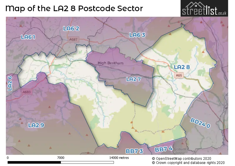
The LA2 8 Postcode shares a border with BB7 3 (Waddington, Slaidburn, West Bradford), BB7 4 (Chatburn, Gisburn, Bolton By Bowland), LA2 6 (Halton, Hest Bank, Slyne), LA2 7 (Bentham, Lower Bentham), LA2 9 (Caton, Brookhouse, Dolphinholme), BD23 4 (Hellifield, Long Preston, Wigglesworth), BD24 0 (Giggleswick, Horton-in-Ribblesdale, Rathmell), LA6 3 (Ingleton, Burton In Lonsdale, Chapel Le Dale), LA6 1 (Holme, Burton, Nether Kellet) and LA6 2 (Kirkby Lonsdale, Casterton, Whittington).
The sector is within the post town of LANCASTER.
LA2 8 is a postcode sector within the LA2 postcode district which is within the LA Lancaster postcode area.
The Royal Mail delivery office for the LA2 8 postal sector is the Lancaster Delivery Office and Wray Scale Payment Delivery Office and Austwick Scale Payment Delivery Office.
The area of the LA2 8 postcode sector is 74.36 square miles which is 192.60 square kilometres or 47,593.30 square acres.
Waterways within the LA2 8 postcode sector include the Clapham Beck, Fell Beck, River Lune, River Hindburn, River Greta, Austwick Beck, River Wenning, Goat Gap Sike, Keasden Beck, Rantree Gill, Outlaw Gill Syke, Barclay's Gill Sike, Cowsen Gill, Kettles Beck, Brow Side Syke, Goat Gill, Hasgill Beck, River Hodder.

Map of the LA2 8 Postcode Sector
Explore the LA2 8 postcode sector by using our free interactive map.
| L | A | 2 | - | 8 | X | X |
| L | A | 2 | Space | 8 | Letter | Letter |
Official List of Streets
Austwick (11 Streets)
Hornby (22 Streets)
Clapham (17 Streets)
Wray (10 Streets)
Gressingham (1 Streets)
Lowgill (1 Streets)
Unofficial Streets or Alternative Spellings
Wray
LANE HEADBentham
MEWITH LANEWeather Forecast for LA2 8
Press Button to Show Forecast for Austwick
| Time Period | Icon | Description | Temperature | Rain Probability | Wind |
|---|---|---|---|---|---|
| 21:00 to 00:00 | Cloudy | 5.0°C (feels like 3.0°C) | 7.00% | WSW 4 mph |
Press Button to Show Forecast for Austwick
| Time Period | Icon | Description | Temperature | Rain Probability | Wind |
|---|---|---|---|---|---|
| 00:00 to 03:00 | Light rain | 6.0°C (feels like 4.0°C) | 51.00% | S 7 mph | |
| 03:00 to 06:00 | Light rain | 6.0°C (feels like 3.0°C) | 53.00% | S 9 mph | |
| 06:00 to 09:00 | Light rain | 7.0°C (feels like 4.0°C) | 53.00% | S 11 mph | |
| 09:00 to 12:00 | Light rain | 9.0°C (feels like 6.0°C) | 56.00% | S 13 mph | |
| 12:00 to 15:00 | Heavy rain | 11.0°C (feels like 8.0°C) | 78.00% | S 13 mph | |
| 15:00 to 18:00 | Heavy rain | 11.0°C (feels like 8.0°C) | 90.00% | S 13 mph | |
| 18:00 to 21:00 | Heavy rain | 10.0°C (feels like 8.0°C) | 92.00% | S 11 mph | |
| 21:00 to 00:00 | Heavy rain | 10.0°C (feels like 7.0°C) | 79.00% | S 11 mph |
Press Button to Show Forecast for Austwick
| Time Period | Icon | Description | Temperature | Rain Probability | Wind |
|---|---|---|---|---|---|
| 00:00 to 03:00 | Light rain | 9.0°C (feels like 6.0°C) | 56.00% | SSE 11 mph | |
| 03:00 to 06:00 | Light rain | 9.0°C (feels like 6.0°C) | 46.00% | SE 11 mph | |
| 06:00 to 09:00 | Partly cloudy (day) | 9.0°C (feels like 6.0°C) | 7.00% | SE 13 mph | |
| 09:00 to 12:00 | Partly cloudy (day) | 12.0°C (feels like 9.0°C) | 3.00% | SE 16 mph | |
| 12:00 to 15:00 | Partly cloudy (day) | 15.0°C (feels like 11.0°C) | 4.00% | SSE 18 mph | |
| 15:00 to 18:00 | Cloudy | 15.0°C (feels like 12.0°C) | 12.00% | SSE 13 mph | |
| 18:00 to 21:00 | Cloudy | 14.0°C (feels like 12.0°C) | 12.00% | SSE 9 mph | |
| 21:00 to 00:00 | Cloudy | 11.0°C (feels like 9.0°C) | 13.00% | SE 7 mph |
Press Button to Show Forecast for Austwick
| Time Period | Icon | Description | Temperature | Rain Probability | Wind |
|---|---|---|---|---|---|
| 00:00 to 03:00 | Cloudy | 9.0°C (feels like 8.0°C) | 12.00% | SE 4 mph | |
| 03:00 to 06:00 | Cloudy | 8.0°C (feels like 7.0°C) | 11.00% | ESE 4 mph | |
| 06:00 to 09:00 | Cloudy | 9.0°C (feels like 8.0°C) | 9.00% | ESE 4 mph | |
| 09:00 to 12:00 | Partly cloudy (day) | 12.0°C (feels like 11.0°C) | 6.00% | ESE 4 mph | |
| 12:00 to 15:00 | Cloudy | 14.0°C (feels like 14.0°C) | 10.00% | SE 7 mph | |
| 15:00 to 18:00 | Cloudy | 15.0°C (feels like 14.0°C) | 11.00% | SE 4 mph | |
| 18:00 to 21:00 | Cloudy | 14.0°C (feels like 13.0°C) | 9.00% | N 4 mph | |
| 21:00 to 00:00 | Cloudy | 11.0°C (feels like 10.0°C) | 6.00% | NNE 4 mph |
Press Button to Show Forecast for Austwick
| Time Period | Icon | Description | Temperature | Rain Probability | Wind |
|---|---|---|---|---|---|
| 00:00 to 03:00 | Cloudy | 10.0°C (feels like 8.0°C) | 7.00% | NNE 4 mph | |
| 03:00 to 06:00 | Cloudy | 9.0°C (feels like 8.0°C) | 7.00% | NNE 4 mph | |
| 06:00 to 09:00 | Cloudy | 10.0°C (feels like 9.0°C) | 6.00% | N 7 mph | |
| 09:00 to 12:00 | Sunny day | 14.0°C (feels like 12.0°C) | 1.00% | N 11 mph | |
| 12:00 to 15:00 | Partly cloudy (day) | 16.0°C (feels like 13.0°C) | 1.00% | NNE 13 mph | |
| 15:00 to 18:00 | Sunny day | 16.0°C (feels like 14.0°C) | 3.00% | NNE 13 mph | |
| 18:00 to 21:00 | Sunny day | 14.0°C (feels like 12.0°C) | 2.00% | NNE 11 mph | |
| 21:00 to 00:00 | Clear night | 10.0°C (feels like 9.0°C) | 2.00% | NNE 9 mph |
Schools and Places of Education Within the LA2 8 Postcode Sector
Austwick Church of England VA Primary School
Voluntary aided school
Austwick, Lancaster, Lancashire, LA2 8BN
Head: Co Headteacher Claire Pearson
Ofsted Rating: Good
Inspection: 2019-05-09 (1816 days ago)
Website: Visit Austwick Church of England VA Primary School Website
Phone: 01524251366
Number of Pupils: 62
Hornby St Margaret's Church of England Primary School
Voluntary aided school
Main Street, Lancaster, Lancashire, LA2 8JY
Head: Mrs Nicole Davison
Ofsted Rating: Good
Inspection: 2022-07-12 (656 days ago)
Website: Visit Hornby St Margaret's Church of England Primary School Website
Phone: 01524221496
Number of Pupils: 48
Tatham Fells Church of England Voluntary Controlled Primary School
Voluntary controlled school
Lowgill, Lancaster, Lancashire, LA2 8RA
Head: Mrs Fiona Ip
Ofsted Rating: Good
Inspection: 2018-11-22 (1984 days ago)
Website: Visit Tatham Fells Church of England Voluntary Controlled Primary School Website
Phone: 01524261441
Number of Pupils: 36
Wray with Botton Endowed Primary School
Voluntary controlled school
School Lane, Lancaster, Lancashire, LA2 8QE
Head: Mrs Anne Phillips
Ofsted Rating: Good
Inspection: 2019-09-11 (1691 days ago)
Website: Visit Wray with Botton Endowed Primary School Website
Phone: 01524221337
Number of Pupils: 56
House Prices in the LA2 8 Postcode Sector
| Type of Property | 2018 Average | 2018 Sales | 2017 Average | 2017 Sales | 2016 Average | 2016 Sales | 2015 Average | 2015 Sales |
|---|---|---|---|---|---|---|---|---|
| Detached | £450,316 | 22 | £400,973 | 28 | £360,350 | 17 | £379,355 | 20 |
| Semi-Detached | £220,650 | 10 | £266,723 | 11 | £306,300 | 10 | £298,643 | 7 |
| Terraced | £232,115 | 13 | £237,958 | 21 | £249,495 | 10 | £244,167 | 12 |
| Flats | £201,000 | 1 | £149,155 | 2 | £186,947 | 7 | £0 | 0 |
Important Postcodes LA2 8 in the Postcode Sector
LA2 8BN is the postcode for MAIN BUILDING, Austwick C of E Primary School, Austwick
LA2 8EF is the postcode for Ingleborough Hall Outdoor Education Centre, Clapham
LA2 8JY is the postcode for Hornby St. Margaret's Church of England Primary School, Main Street
LA2 8LH is the postcode for Hornby High School, Melling Road
LA2 8NS is the postcode for Wennington Hall School, Lodge Lane, SPORTS HALL, Wennington Hall School, Lodge Lane, and VOCATIONAL CENTRE, Wennington Hall School, Lodge Lane
| The LA2 8 Sector is within these Local Authorities |
|
|---|---|
| The LA2 8 Sector is within these Counties |
|
| The LA2 8 Sector is within these Water Company Areas |
|