The LA2 9 postcode sector is within the county of Lancashire.
Did you know? According to the 2021 Census, the LA2 9 postcode sector is home to a bustling 4,444 residents!
Given that each sector allows for 400 unique postcode combinations. Letters C, I, K, M, O and V are not allowed in the last two letters of a postcode. With 209 postcodes already in use, this leaves 191 units available.
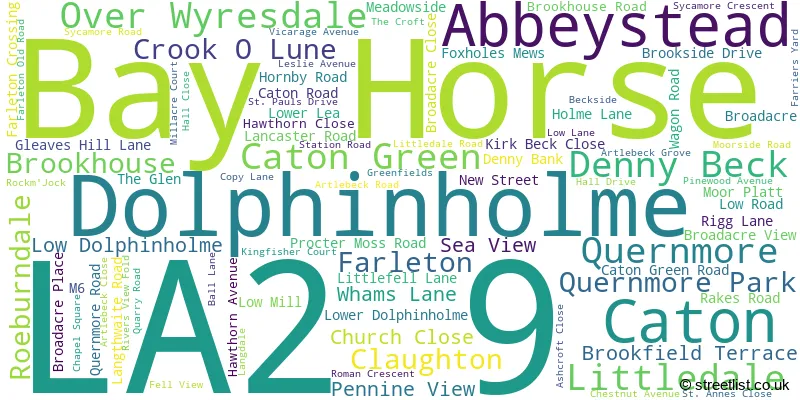
The largest settlement in the LA2 9 postal code is Caton followed by Brookhouse, and Dolphinholme.
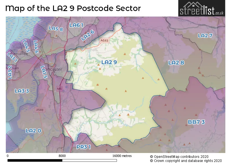
The LA2 9 Postcode shares a border with PR3 0 (Great Eccleston, Forton, Catterall), PR3 1 (Garstang, Cabus, Catterall), BB7 3 (Waddington, Slaidburn, West Bradford), LA1 3 (LANCASTER, Lansil Industrial Estate), LA2 0 (Ellel, Galgate, Cockerham), LA2 6 (Halton, Hest Bank, Slyne) and LA2 8 (Clapham, Austwick, Hornby).
The sector is within the post town of LANCASTER.
LA2 9 is a postcode sector within the LA2 postcode district which is within the LA Lancaster postcode area.
The Royal Mail delivery office for the LA2 9 postal sector is the Lancaster Delivery Office.
The area of the LA2 9 postcode sector is 69.06 square miles which is 178.87 square kilometres or 44,200.73 square acres.
The LA2 9 postcode sector is crossed by the M6 motorway.
Waterways within the LA2 9 postcode sector include the River Wyre, River Grizedale, Tarnbrook Wyre, Marshaw Wyre, Tarnsyke Clough, Thrush Clough, Deer Clough, River Lune, River Wenning.

Map of the LA2 9 Postcode Sector
Explore the LA2 9 postcode sector by using our free interactive map.
| L | A | 2 | - | 9 | X | X |
| L | A | 2 | Space | 9 | Letter | Letter |
Official List of Streets
Caton (29 Streets)
Bay Horse (6 Streets)
Brookhouse (18 Streets)
Dolphinholme (5 Streets)
Caton Green (2 Streets)
Claughton (5 Streets)
Farleton (1 Streets)
Quernmore (3 Streets)
Abbeystead (2 Streets)
Low Dolphinholme (1 Streets)
Unofficial Streets or Alternative Spellings
Dunsop Bridge
TROUGH ROADForton
HOLLINS LANE WHITE CARR LANEEllel
STONEY LANECaton
FARRIERS YARDHornby
LANCASTER ROAD MOOR LANECrook O Lune
CATON ROADWeather Forecast for LA2 9
Press Button to Show Forecast for Williamson Park Lancaster
| Time Period | Icon | Description | Temperature | Rain Probability | Wind |
|---|---|---|---|---|---|
| 06:00 to 09:00 | Sunny day | 3.0°C (feels like 1.0°C) | 1.00% | ENE 4 mph | |
| 09:00 to 12:00 | Cloudy | 7.0°C (feels like 5.0°C) | 4.00% | ENE 4 mph | |
| 12:00 to 15:00 | Overcast | 8.0°C (feels like 7.0°C) | 13.00% | NNE 4 mph | |
| 15:00 to 18:00 | Overcast | 9.0°C (feels like 8.0°C) | 10.00% | N 4 mph | |
| 18:00 to 21:00 | Cloudy | 8.0°C (feels like 6.0°C) | 8.00% | NNE 4 mph | |
| 21:00 to 00:00 | Partly cloudy (night) | 5.0°C (feels like 3.0°C) | 2.00% | ENE 4 mph |
Press Button to Show Forecast for Williamson Park Lancaster
| Time Period | Icon | Description | Temperature | Rain Probability | Wind |
|---|---|---|---|---|---|
| 00:00 to 03:00 | Partly cloudy (night) | 3.0°C (feels like 1.0°C) | 2.00% | E 4 mph | |
| 03:00 to 06:00 | Partly cloudy (night) | 2.0°C (feels like 0.0°C) | 3.00% | E 4 mph | |
| 06:00 to 09:00 | Partly cloudy (day) | 4.0°C (feels like 2.0°C) | 3.00% | E 4 mph | |
| 09:00 to 12:00 | Partly cloudy (day) | 8.0°C (feels like 6.0°C) | 6.00% | E 7 mph | |
| 12:00 to 15:00 | Cloudy | 10.0°C (feels like 8.0°C) | 9.00% | E 7 mph | |
| 15:00 to 18:00 | Cloudy | 10.0°C (feels like 8.0°C) | 14.00% | ENE 7 mph | |
| 18:00 to 21:00 | Cloudy | 9.0°C (feels like 7.0°C) | 11.00% | E 9 mph | |
| 21:00 to 00:00 | Partly cloudy (night) | 6.0°C (feels like 4.0°C) | 9.00% | ENE 7 mph |
Press Button to Show Forecast for Williamson Park Lancaster
| Time Period | Icon | Description | Temperature | Rain Probability | Wind |
|---|---|---|---|---|---|
| 00:00 to 03:00 | Partly cloudy (night) | 4.0°C (feels like 2.0°C) | 10.00% | NE 7 mph | |
| 03:00 to 06:00 | Cloudy | 4.0°C (feels like 1.0°C) | 11.00% | NNE 9 mph | |
| 06:00 to 09:00 | Cloudy | 6.0°C (feels like 3.0°C) | 15.00% | NNE 9 mph | |
| 09:00 to 12:00 | Cloudy | 8.0°C (feels like 5.0°C) | 19.00% | NNE 9 mph | |
| 12:00 to 15:00 | Light rain | 9.0°C (feels like 6.0°C) | 46.00% | NNE 11 mph | |
| 15:00 to 18:00 | Heavy rain | 10.0°C (feels like 7.0°C) | 71.00% | N 9 mph | |
| 18:00 to 21:00 | Light rain shower (day) | 10.0°C (feels like 7.0°C) | 40.00% | NW 9 mph | |
| 21:00 to 00:00 | Partly cloudy (night) | 7.0°C (feels like 5.0°C) | 10.00% | WNW 9 mph |
Schools and Places of Education Within the LA2 9 Postcode Sector
Caton Primary School
Community school
Broadacre, Lancaster, Lancashire, LA2 9NH
Head: Ms Gail Bowskill
Ofsted Rating: Good
Inspection: 2019-05-16 (1807 days ago)
Website: Visit Caton Primary School Website
Phone: 01524770104
Number of Pupils: 73
Caton St Paul's Church of England Primary School
Voluntary aided school
Moorside Road, Lancaster, Lancashire, LA2 9PJ
Head: Mr Ian Gittins
Ofsted Rating: Good
Inspection: 2022-05-05 (722 days ago)
Website: Visit Caton St Paul's Church of England Primary School Website
Phone: 01524770241
Number of Pupils: 156
Cawthorne's Endowed School
Voluntary aided school
Abbeystead Road, Lancaster, Lancashire, LA2 9BQ
Head: Mr Patrick Corbett
Ofsted Rating: Outstanding
Inspection: 2012-05-16 (4363 days ago)
Website: Visit Cawthorne's Endowed School Website
Phone: 01524791565
Number of Pupils: 35
Dolphinholme Church of England Primary School
Voluntary aided school
Dolphinholme, Lancaster, Lancashire, LA2 9AN
Head: Miss Joanne Mather
Ofsted Rating: Outstanding
Inspection: 2013-04-19 (4025 days ago)
Website: Visit Dolphinholme Church of England Primary School Website
Phone: 01524791530
Number of Pupils: 91
Quernmore Church of England Voluntary Controlled Primary School
Voluntary controlled school
Postern Gate Road, Lancaster, Lancashire, LA2 9EL
Head: Miss Fiona Richardson
Ofsted Rating: Good
Inspection: 2019-03-20 (1864 days ago)
Website: Visit Quernmore Church of England Voluntary Controlled Primary School Website
Phone: 0152466628
Number of Pupils: 94
House Prices in the LA2 9 Postcode Sector
| Type of Property | 2018 Average | 2018 Sales | 2017 Average | 2017 Sales | 2016 Average | 2016 Sales | 2015 Average | 2015 Sales |
|---|---|---|---|---|---|---|---|---|
| Detached | £358,766 | 28 | £328,283 | 23 | £370,667 | 12 | £331,421 | 19 |
| Semi-Detached | £229,775 | 20 | £206,438 | 8 | £247,194 | 18 | £208,235 | 17 |
| Terraced | £187,038 | 13 | £149,864 | 11 | £211,000 | 7 | £170,408 | 18 |
| Flats | £138,000 | 5 | £103,875 | 4 | £150,369 | 8 | £201,467 | 6 |
Important Postcodes LA2 9 in the Postcode Sector
LA2 9AN is the postcode for Dolphinholme C of E School, Dolphinholme
LA2 9BQ is the postcode for Cawthornes Endowed School, Abbeystead
LA2 9EL is the postcode for Quernmore C of E School, Quernmore
LA2 9NH is the postcode for Caton Primary School, Broadacre
LA2 9PJ is the postcode for St. Pauls C of E Primary School, Moorside Road
| The LA2 9 Sector is within these Local Authorities |
|
|---|---|
| The LA2 9 Sector is within these Counties |
|
| The LA2 9 Sector is within these Water Company Areas |
|