The LA9 postcode district is a postal district located in the LA Lancaster postcode area with a population of 31,835 residents according to the 2021 England and Wales Census.
The area of the LA9 postcode district is 12.31 square miles which is 31.88 square kilometres or 7,877.54 acres.
Currently, the LA9 district has about 924 postcode units spread across 4 geographic postcode sectors.
Given that each sector allows for 400 unique postcode combinations, the district has a capacity of 1,600 postcodes. With 924 postcodes already in use, this leaves 676 units available.
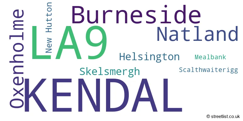
The largest settlement in the LA9 postal code is KENDAL followed by Burneside, and Oxenholme.
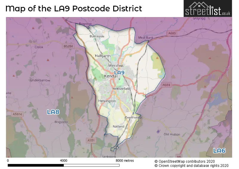
The LA9 Postcode shares a border with LA8 (Staveley, Levens, Endmoor).
The primary settlement in the LA9 postcode district is Kendal, located in the county of Cumbria, England. Other significant settlements in the district include Burneside, Helsington, Mealbank, New Hutton, Scalthwaiterigg, Skelsmergh, and Natland. The most significant post town in the district is Kendal.
For the district LA9, we have data on 5 postcode sectors. Here's a breakdown: The sector LA9 4, covers Kendal in Cumbria. The sector LA9 5, covers Kendal in Cumbria. The sector LA9 6, covers Kendal and Burneside in Cumbria. The sector LA9 7, covers Kendal and Natland in Cumbria. The sector LA9 9 is non-geographic. It's often designated for PO Boxes, large organisations, or special services.

Map of the LA9 Postcode District
Explore the LA9 postcode district by using our free interactive map.
When it comes to local government, postal geography often disregards political borders. However, for a breakdown in the LA9 District: the district mostly encompasses the Westmorland and Furness area with a total of 946 postcodes.
Recent House Sales in LA9
| Date | Price | Address |
|---|---|---|
| 26/10/2023 | £135,000 | Sandes Avenue, Kendal, LA9 4LN |
| 23/10/2023 | £795,000 | Oxenholme Lane, Natland, Kendal, LA9 7QH |
| 18/10/2023 | £127,500 | Greencoats Yard, Kendal, LA9 4XA |
| 16/10/2023 | £195,000 | Gardiner Bank, Kendal, LA9 4SL |
| 13/10/2023 | £230,000 | Ashleigh Road, Kendal, LA9 4SS |
| 09/10/2023 | £410,000 | River Bank Road, Kendal, LA9 5JS |
| 02/10/2023 | £255,000 | High Sparrowmire, Kendal, LA9 5PD |
| 29/09/2023 | £120,000 | Websters Yard, Kendal, LA9 4HA |
| 18/09/2023 | £350,000 | Esthwaite Green, Kendal, LA9 7RZ |
| 18/09/2023 | £480,000 | Rochester Gardens, Oxenholme, Kendal, LA9 7TE |
Weather Forecast for LA9
Press Button to Show Forecast for Kendal
| Time Period | Icon | Description | Temperature | Rain Probability | Wind |
|---|---|---|---|---|---|
| 00:00 to 03:00 | Clear night | 2.0°C (feels like 0.0°C) | 0.00% | ENE 4 mph | |
| 03:00 to 06:00 | Clear night | 1.0°C (feels like -1.0°C) | 1.00% | ENE 4 mph | |
| 06:00 to 09:00 | Sunny day | 2.0°C (feels like 1.0°C) | 1.00% | ENE 2 mph | |
| 09:00 to 12:00 | Cloudy | 7.0°C (feels like 6.0°C) | 4.00% | ENE 4 mph | |
| 12:00 to 15:00 | Cloudy | 9.0°C (feels like 7.0°C) | 8.00% | NE 4 mph | |
| 15:00 to 18:00 | Cloudy | 9.0°C (feels like 8.0°C) | 7.00% | NNE 4 mph | |
| 18:00 to 21:00 | Cloudy | 8.0°C (feels like 6.0°C) | 8.00% | NNE 4 mph | |
| 21:00 to 00:00 | Partly cloudy (night) | 4.0°C (feels like 3.0°C) | 2.00% | ENE 4 mph |
Press Button to Show Forecast for Kendal
| Time Period | Icon | Description | Temperature | Rain Probability | Wind |
|---|---|---|---|---|---|
| 00:00 to 03:00 | Partly cloudy (night) | 3.0°C (feels like 1.0°C) | 2.00% | E 4 mph | |
| 03:00 to 06:00 | Partly cloudy (night) | 2.0°C (feels like 0.0°C) | 3.00% | E 4 mph | |
| 06:00 to 09:00 | Partly cloudy (day) | 4.0°C (feels like 2.0°C) | 3.00% | E 4 mph | |
| 09:00 to 12:00 | Partly cloudy (day) | 8.0°C (feels like 6.0°C) | 6.00% | E 7 mph | |
| 12:00 to 15:00 | Cloudy | 10.0°C (feels like 8.0°C) | 12.00% | E 7 mph | |
| 15:00 to 18:00 | Cloudy | 10.0°C (feels like 8.0°C) | 14.00% | E 7 mph | |
| 18:00 to 21:00 | Cloudy | 9.0°C (feels like 7.0°C) | 11.00% | E 7 mph | |
| 21:00 to 00:00 | Partly cloudy (night) | 6.0°C (feels like 4.0°C) | 9.00% | ENE 7 mph |
Press Button to Show Forecast for Kendal
| Time Period | Icon | Description | Temperature | Rain Probability | Wind |
|---|---|---|---|---|---|
| 00:00 to 03:00 | Partly cloudy (night) | 5.0°C (feels like 2.0°C) | 10.00% | NE 7 mph | |
| 03:00 to 06:00 | Cloudy | 4.0°C (feels like 1.0°C) | 11.00% | NE 9 mph | |
| 06:00 to 09:00 | Cloudy | 6.0°C (feels like 3.0°C) | 15.00% | NNE 9 mph | |
| 09:00 to 12:00 | Cloudy | 8.0°C (feels like 5.0°C) | 19.00% | NNE 9 mph | |
| 12:00 to 15:00 | Light rain | 9.0°C (feels like 6.0°C) | 46.00% | NNE 9 mph | |
| 15:00 to 18:00 | Heavy rain | 10.0°C (feels like 8.0°C) | 71.00% | NNE 9 mph | |
| 18:00 to 21:00 | Light rain shower (day) | 10.0°C (feels like 8.0°C) | 38.00% | NW 9 mph | |
| 21:00 to 00:00 | Clear night | 7.0°C (feels like 5.0°C) | 10.00% | NNW 7 mph |
Where is the LA9 Postcode District?
The postcode district for LA9 is located in KENDAL. KENDAL is a district town that is situated nearby several other towns. To the South of KENDAL is MILNTHORPE, which is approximately 7.4 miles away. WINDERMERE is located to the West, about 7.8 miles away. To the East is SEDBERGH, which is approximately 8.6 miles away. Ambleside is situated to the North West, approximately 11.4 miles away. GRANGE-OVER-SANDS is located to the South West, about 11.7 miles away. Lastly, KIRKBY STEPHEN is situated to the North East, approximately 18.6 miles away. In terms of distance from the centre of London, the LA9 postcode district is approximately 223.5 miles away.
The district is within the post town of KENDAL.
The sector has postcodes within the nation of England.
The LA9 Postcode District is in the East Cumbria region of Cumbria within the North West (England).
Postcode Districts that Share a Border with LA9
| Postcode Sector | Delivery Office |
|---|---|
| LA9 4 | Kendal Delivery Office |
| LA9 5 | Kendal Delivery Office |
| LA9 6 | Kendal Delivery Office |
| LA9 7 | Kendal Delivery Office |
| L | A | 9 | - | X | X | X |
| L | A | 9 | Space | Numeric | Letter | Letter |
Tourist Attractions within the Postcode Area
We found 4 visitor attractions within the LA9 postcode area
| Museum of Lakeland Life |
|---|
| Museums & Art Galleries |
| Museum and / or Art Gallery |
| View Museum of Lakeland Life on Google Maps |
| Abbot Hall Art Gallery |
| Museums & Art Galleries |
| Museum and / or Art Gallery |
| View Abbot Hall Art Gallery on Google Maps |
| Quaker Tapestry Exhibition |
| Museums & Art Galleries |
| Museum and / or Art Gallery |
| View Quaker Tapestry Exhibition on Google Maps |
| Kendal Museum |
| Museums & Art Galleries |
| Museum and / or Art Gallery |
| View Kendal Museum on Google Maps |
Current Monthly Rental Prices
| # Bedrooms | Min Price | Max Price | Avg Price |
|---|---|---|---|
| 1 | £625 | £750 | £678 |
| 2 | £650 | £995 | £805 |
| 3 | £850 | £1,100 | £975 |
Current House Prices
| # Bedrooms | Min Price | Max Price | Avg Price |
|---|---|---|---|
| £150,000 | £150,000 | £150,000 | |
| 1 | £50,000 | £249,950 | £124,728 |
| 2 | £87,500 | £400,000 | £230,051 |
| 3 | £125,000 | £755,000 | £310,229 |
| 4 | £225,000 | £995,000 | £468,823 |
| 5 | £330,000 | £950,000 | £626,315 |
| 6 | £350,000 | £850,000 | £516,000 |
| 7 | £995,000 | £995,000 | £995,000 |
| 8 | £350,000 | £1,350,000 | £850,000 |
Estate Agents who Operate in the LA9 District
| Logo | Name | Brand Name | Address | Contact Number | Total Properties |
|---|---|---|---|---|---|
 | Kendal | Arnold Greenwood Estate Agents | 8-10 Highgate Kendal LA9 4SX | 01539 885312 | 46 |
 | Kendal | Poole Townsend | 2 Market Place Kendal LA9 4TN | 01539 761289 | 41 |
 | Kendal | Hackney & Leigh | 100 Stricklandgate Kendal Cumbria LA9 4PU | 01539 885313 | 40 |
 | Kendal | Milne Moser | 100 Highgate, Kendal, LA9 4HE | 01539 761560 | 30 |
 | Kendal | Thomson Hayton Winkley Estate Agents | 112 Stricklandgate Kendal LA9 4QA | 01539 885305 | 28 |
| Type of Property | 2018 Average | 2018 Sales | 2017 Average | 2017 Sales | 2016 Average | 2016 Sales | 2015 Average | 2015 Sales |
|---|---|---|---|---|---|---|---|---|
| Detached | £327,403 | 125 | £333,971 | 137 | £321,946 | 117 | £315,771 | 129 |
| Semi-Detached | £214,255 | 172 | £211,983 | 204 | £201,962 | 169 | £204,345 | 188 |
| Terraced | £193,101 | 200 | £180,492 | 206 | £176,786 | 211 | £171,212 | 242 |
| Flats | £136,773 | 108 | £136,173 | 123 | £153,550 | 122 | £154,250 | 147 |