The LL71 7 postcode sector is within the county of Gwynedd.
Did you know? According to the 2021 Census, the LL71 7 postcode sector is home to a bustling 513 residents!
Given that each sector allows for 400 unique postcode combinations. Letters C, I, K, M, O and V are not allowed in the last two letters of a postcode. With 32 postcodes already in use, this leaves 368 units available.
The largest settlement in the LL71 7 postal code is LLANERCHYMEDD followed by CARMEL, and LLANDRYGAN.
The LL71 7 Postcode shares a border with LL68 9 (AMLWCH, BULL BAY, RHOSYBOL), LL71 8 (LLANERCHYMEDD, LLANDYFRYDOG, MYNYDD BODAFON), LL65 3 (VALLEY, CAERGEILIOG, BODEDERN), LL65 4 (GWALCHMAI, LLANFACHRAETH, HOLYHEAD) and LL66 0 (RHOSGOCH, CARREGLEFN, AMLWCH).
The sector is within the post town of LLANNERCH-Y-MEDD.
LL71 7 is a postcode sector within the LL71 postcode district which is within the LL Llandudno postcode area.
The Royal Mail delivery office for the LL71 7 postal sector is the Llangefni Delivery Office.
The area of the LL71 7 postcode sector is 9.15 square miles which is 23.69 square kilometres or 5,852.85 square acres.

Map of the LL71 7 Postcode Sector
Explore the LL71 7 postcode sector by using our free interactive map.
| L | L | 7 | 1 | - | 7 | X | X |
| L | L | 7 | 1 | Space | 7 | Letter | Letter |
Official List of Streets
Unofficial Streets or Alternative Spellings
LLANNERCH-Y-MEDD
BRIDGE STREET GLAN ABER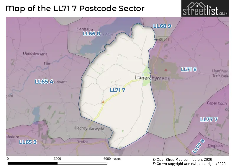
House Prices in the LL71 7 Postcode Sector
| Type of Property | 2018 Average | 2018 Sales | 2017 Average | 2017 Sales | 2016 Average | 2016 Sales | 2015 Average | 2015 Sales |
|---|---|---|---|---|---|---|---|---|
| Detached | £234,583 | 6 | £243,917 | 3 | £205,488 | 4 | £163,500 | 4 |
| Semi-Detached | £173,500 | 2 | £0 | 0 | £0 | 0 | £0 | 0 |
| Terraced | £89,250 | 2 | £85,750 | 2 | £77,500 | 2 | £78,500 | 2 |
| Flats | £0 | 0 | £0 | 0 | £0 | 0 | £0 | 0 |
| The LL71 7 Sector is within these Local Authorities |
|
|---|---|
| The LL71 7 Sector is within these Counties |
|
| The LL71 7 Sector is within these Water Company Areas |
|