The M14 7 postcode sector is within the county of Greater Manchester.
Did you know? According to the 2021 Census, the M14 7 postcode sector is home to a bustling 14,442 residents!
Given that each sector allows for 400 unique postcode combinations. Letters C, I, K, M, O and V are not allowed in the last two letters of a postcode. With 232 postcodes already in use, this leaves 168 units available.
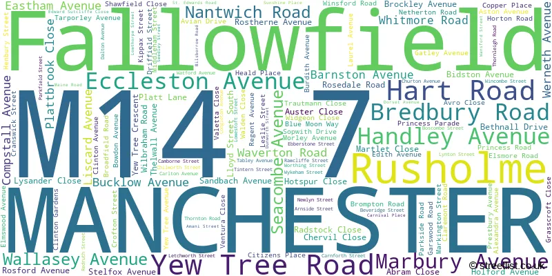
The largest settlement in the M14 7 postal code is MANCHESTER followed by Rusholme, and Fallowfield.
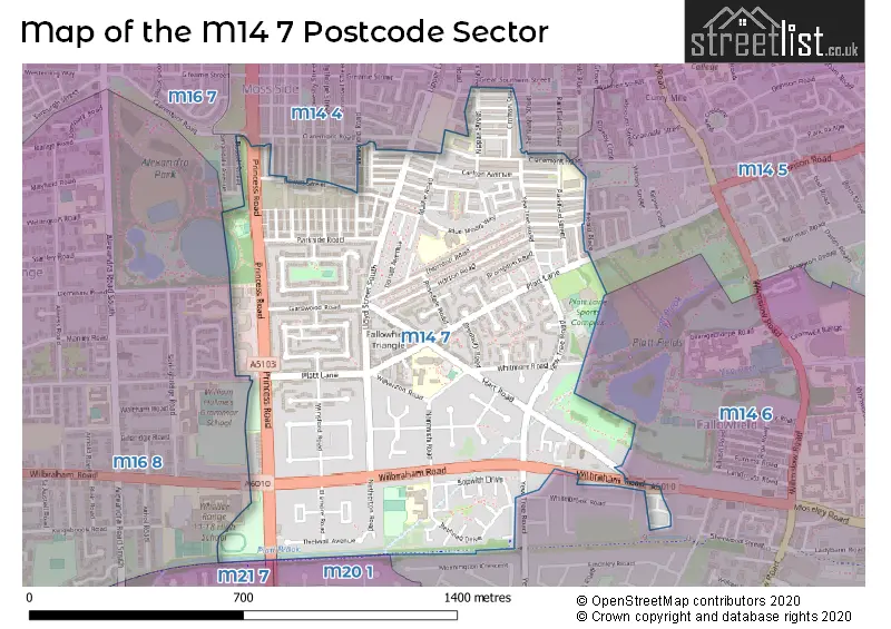
The M14 7 Postcode shares a border with M21 7 (MANCHESTER, Chorlton Cum Hardy), M14 4 (MANCHESTER), M14 5 (MANCHESTER), M14 6 (MANCHESTER, Fallowfield), M20 1 (MANCHESTER, Withington), M16 7 (MANCHESTER, Old Trafford, Moss Side) and M16 8 (MANCHESTER, Whalley Range).
The sector is within the post town of MANCHESTER.
M14 7 is a postcode sector within the M14 postcode district which is within the M Manchester postcode area.
The Royal Mail delivery office for the M14 7 postal sector is the Manchester South Delivery Office.
The area of the M14 7 postcode sector is 0.59 square miles which is 1.52 square kilometres or 374.83 square acres.

Map of the M14 7 Postcode Sector
Explore the M14 7 postcode sector by using our free interactive map.
| M | 1 | 4 | - | 7 | X | X |
| M | 1 | 4 | Space | 7 | Letter | Letter |
Official List of Streets
MANCHESTER (119 Streets)
Rusholme (2 Streets)
Fallowfield (2 Streets)
Unofficial Streets or Alternative Spellings
Weather Forecast for M14 7
Press Button to Show Forecast for Moss Side
| Time Period | Icon | Description | Temperature | Rain Probability | Wind |
|---|---|---|---|---|---|
| 00:00 to 03:00 | Cloudy | 7.0°C (feels like 4.0°C) | 5.00% | NE 9 mph | |
| 03:00 to 06:00 | Light rain | 6.0°C (feels like 3.0°C) | 54.00% | NNE 11 mph | |
| 06:00 to 09:00 | Heavy rain | 6.0°C (feels like 3.0°C) | 86.00% | N 9 mph | |
| 09:00 to 12:00 | Heavy rain | 6.0°C (feels like 3.0°C) | 87.00% | NNW 9 mph | |
| 12:00 to 15:00 | Light rain | 7.0°C (feels like 4.0°C) | 58.00% | WNW 11 mph | |
| 15:00 to 18:00 | Light rain shower (day) | 9.0°C (feels like 6.0°C) | 37.00% | WNW 13 mph | |
| 18:00 to 21:00 | Cloudy | 10.0°C (feels like 7.0°C) | 7.00% | W 11 mph | |
| 21:00 to 00:00 | Partly cloudy (night) | 8.0°C (feels like 6.0°C) | 2.00% | SW 7 mph |
Press Button to Show Forecast for Moss Side
| Time Period | Icon | Description | Temperature | Rain Probability | Wind |
|---|---|---|---|---|---|
| 00:00 to 03:00 | Partly cloudy (night) | 6.0°C (feels like 4.0°C) | 2.00% | SSW 7 mph | |
| 03:00 to 06:00 | Cloudy | 6.0°C (feels like 3.0°C) | 39.00% | S 9 mph | |
| 06:00 to 09:00 | Cloudy | 7.0°C (feels like 4.0°C) | 8.00% | S 9 mph | |
| 09:00 to 12:00 | Cloudy | 10.0°C (feels like 8.0°C) | 10.00% | S 13 mph | |
| 12:00 to 15:00 | Light rain shower (day) | 13.0°C (feels like 10.0°C) | 31.00% | S 16 mph | |
| 15:00 to 18:00 | Cloudy | 14.0°C (feels like 11.0°C) | 12.00% | S 16 mph | |
| 18:00 to 21:00 | Cloudy | 13.0°C (feels like 11.0°C) | 11.00% | S 13 mph | |
| 21:00 to 00:00 | Cloudy | 11.0°C (feels like 9.0°C) | 6.00% | SSE 11 mph |
Press Button to Show Forecast for Moss Side
| Time Period | Icon | Description | Temperature | Rain Probability | Wind |
|---|---|---|---|---|---|
| 00:00 to 03:00 | Cloudy | 10.0°C (feels like 8.0°C) | 6.00% | SSE 11 mph | |
| 03:00 to 06:00 | Partly cloudy (night) | 9.0°C (feels like 7.0°C) | 2.00% | SE 11 mph | |
| 06:00 to 09:00 | Sunny day | 9.0°C (feels like 7.0°C) | 2.00% | SE 11 mph | |
| 09:00 to 12:00 | Sunny day | 13.0°C (feels like 11.0°C) | 1.00% | SE 13 mph | |
| 12:00 to 15:00 | Cloudy | 16.0°C (feels like 13.0°C) | 6.00% | SE 16 mph | |
| 15:00 to 18:00 | Cloudy | 17.0°C (feels like 14.0°C) | 8.00% | SE 13 mph | |
| 18:00 to 21:00 | Sunny day | 15.0°C (feels like 14.0°C) | 8.00% | ESE 9 mph | |
| 21:00 to 00:00 | Partly cloudy (night) | 13.0°C (feels like 12.0°C) | 4.00% | E 7 mph |
Press Button to Show Forecast for Moss Side
| Time Period | Icon | Description | Temperature | Rain Probability | Wind |
|---|---|---|---|---|---|
| 00:00 to 03:00 | Cloudy | 12.0°C (feels like 10.0°C) | 8.00% | E 7 mph | |
| 03:00 to 06:00 | Cloudy | 11.0°C (feels like 10.0°C) | 11.00% | ENE 7 mph | |
| 06:00 to 09:00 | Cloudy | 11.0°C (feels like 10.0°C) | 15.00% | ENE 7 mph | |
| 09:00 to 12:00 | Cloudy | 14.0°C (feels like 13.0°C) | 12.00% | E 7 mph | |
| 12:00 to 15:00 | Cloudy | 16.0°C (feels like 15.0°C) | 14.00% | E 9 mph | |
| 15:00 to 18:00 | Cloudy | 18.0°C (feels like 16.0°C) | 15.00% | E 9 mph | |
| 18:00 to 21:00 | Cloudy | 16.0°C (feels like 15.0°C) | 12.00% | ENE 9 mph | |
| 21:00 to 00:00 | Cloudy | 13.0°C (feels like 12.0°C) | 9.00% | ENE 9 mph |
Schools and Places of Education Within the M14 7 Postcode Sector
Claremont Primary School
Community school
Claremont Road, Manchester, Lancashire, M14 7NA
Head: Miss Anne Conboy
Ofsted Rating: Good
Inspection: 2023-10-05 (206 days ago)
Website: Visit Claremont Primary School Website
Phone: 01612262066
Number of Pupils: 640
Heald Place Primary School
Community school
Heald Place, Manchester, , M14 7PN
Head: Mr Hatim Kapacee
Ofsted Rating: Good
Inspection: 2019-03-27 (1859 days ago)
Website: Visit Heald Place Primary School Website
Phone: 01612247079
Number of Pupils: 658
The Divine Mercy Roman Catholic Primary School
Voluntary aided school
20 Blue Moon Way, Manchester, , M14 7SH
Head: Mrs Clare Campbell
Ofsted Rating: Good
Inspection: 2023-03-14 (411 days ago)
Website: Visit The Divine Mercy Roman Catholic Primary School Website
Phone: 01616728660
Number of Pupils: 469
Wilbraham Primary School
Academy converter
Platt Lane, Manchester, , M14 7FB
Head: Mr Andrew Marchant
Ofsted Rating: Good
Inspection: 2022-09-15 (591 days ago)
Website: Visit Wilbraham Primary School Website
Phone: 01612243900
Number of Pupils: 652
House Prices in the M14 7 Postcode Sector
| Type of Property | 2018 Average | 2018 Sales | 2017 Average | 2017 Sales | 2016 Average | 2016 Sales | 2015 Average | 2015 Sales |
|---|---|---|---|---|---|---|---|---|
| Detached | £309,833 | 3 | £248,916 | 6 | £253,650 | 3 | £177,950 | 4 |
| Semi-Detached | £179,451 | 25 | £188,457 | 36 | £156,910 | 40 | £145,535 | 30 |
| Terraced | £141,559 | 130 | £132,680 | 142 | £128,783 | 214 | £113,835 | 162 |
| Flats | £137,430 | 22 | £130,107 | 23 | £114,892 | 26 | £102,512 | 10 |
Important Postcodes M14 7 in the Postcode Sector
M14 7ED is the postcode for MAIN BUILDING, St. Kentigerns RC Primary School, Bethnall Drive, INFANTS BUILDING, St. Kentigerns RC Primary School, Bethnall Drive, and St. Kentigerns RC Primary School, Bethnall Drive
M14 7FB is the postcode for MAIN BUILDING, Wilbraham Primary School, Platt Lane, Wilbraham Primary School, Platt Lane, NEW SCHOOL BLOCK 2015, Wilbraham Primary School, Platt Lane, and NURSERY & SURESTART, Wilbraham Primary School, Platt Lane
M14 7LU is the postcode for Parkway Three, Princess Road, Parkway Business Centre, NHS Manchester, Parkway One, Princess Road, Parkway Business Centre, Parkway Three, Parkway Business Centre, and Parkway Three, Princess Road
M14 7NA is the postcode for Claremont Primary School, Claremont Road
M14 7PN is the postcode for MAIN BUILDING, Heald Place Primary School, Parkfield Street, NEW BUILDING, Heald Place Primary School, Parkfield Street, Heald Place Primary School, Parkfield Street, and CENTENARY BUILDING, Heald Place Primary School, Parkfield Street
M14 7PW is the postcode for St. Edwards RC Primary School, Yew Tree Road
M14 7SH is the postcode for New Divine Mercy School, 20 Blue Moon Way
M14 7UU is the postcode for Leisure Dome, Platt Lane Complex, Leisure Dome, Yew Tree Road, and Platt Lane Complex, Yew Tree Road
| The M14 7 Sector is within these Local Authorities |
|
|---|---|
| The M14 7 Sector is within these Counties |
|
| The M14 7 Sector is within these Water Company Areas |
|