The M16 7 postcode sector is within the county of Greater Manchester.
Did you know? According to the 2021 Census, the M16 7 postcode sector is home to a bustling 7,960 residents!
Given that each sector allows for 400 unique postcode combinations. Letters C, I, K, M, O and V are not allowed in the last two letters of a postcode. With 195 postcodes already in use, this leaves 205 units available.
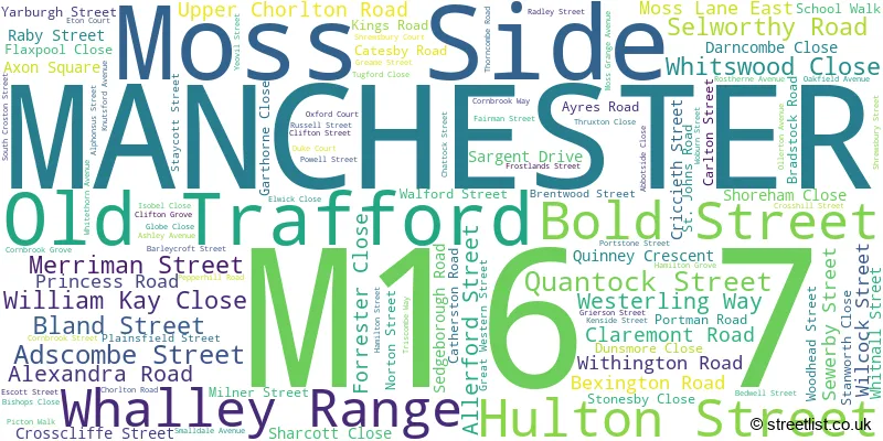
The largest settlement in the M16 7 postal code is MANCHESTER followed by Old Trafford, and Moss Side.
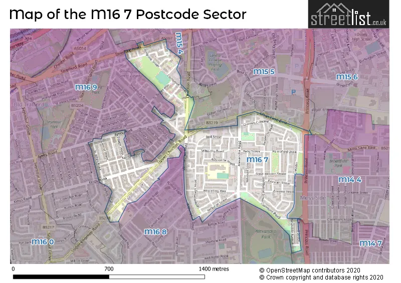
The M16 7 Postcode shares a border with M15 6 (MANCHESTER, Manchester Science Park), M14 4 (MANCHESTER), M14 7 (MANCHESTER, Rusholme, Fallowfield), M15 4 (MANCHESTER), M15 5 (MANCHESTER, Hulme), M16 8 (MANCHESTER, Whalley Range) and M16 9 (MANCHESTER, Old Trafford).
The sector is within the post town of MANCHESTER.
M16 7 is a postcode sector within the M16 postcode district which is within the M Manchester postcode area.
The Royal Mail delivery office for the M16 7 postal sector is the South West (m) Delivery Office.
The area of the M16 7 postcode sector is 0.36 square miles which is 0.93 square kilometres or 230.90 square acres.

Map of the M16 7 Postcode Sector
Explore the M16 7 postcode sector by using our free interactive map.
| M | 1 | 6 | - | 7 | X | X |
| M | 1 | 6 | Space | 7 | Letter | Letter |
Official List of Streets
MANCHESTER (93 Streets)
Moss Side (1 Streets)
Old Trafford (9 Streets)
Whalley Range (2 Streets)
Unofficial Streets or Alternative Spellings
MANCHESTER
ALEXANDRA ROAD SOUTH ANVIL PLACE AUGUSTUS WAY CHICHESTER ROAD DARNLEY STREET DENHILL ROAD DUDLEY ROAD ESSEX WAY HENRIETTA STREET JOHNSON STREET MOSS LANE WEST STAMFORD STREET SYLVAN AVENUE TELFORD WALK WHITCHURCH DRIVEHulme
CHICHESTER ROAD SOUTH STRETFORD ROADChorlton Cum Hardy
WITHINGTON ROAD BEDWELL CLOSE CARRIAGE STREET CASTON CLOSE CATHERSTON CLOSE CLIFTON CLOSE CLIFTON HOUSE CROSTON STREET CROSTON TERRACE DUKE CLOSE ETON CLOSE FINBOROUGH CLOSE GLADYS STREET GLOBE TRADING ESTATE GREAT WESTERN ROAD HILDEN COURT HULTON DRIVE LIME WALK MELLORS CLOSE MYRTLE STREET NURSERY STREET OXFORD STREET PLAINSFIELD CLOSE PORTMAN CLOSE PORTSTONE CLOSE RAISED WALK RINGFIELD CLOSE SEWERBY CLOSE SHREWSBURY CLOSE ST BRIDES WAY ST MARYS STREET STOCKTON STREET TRENT CLOSE WILCOCK CLOSEOld Trafford
RUSHMERE WALKWeather Forecast for M16 7
Press Button to Show Forecast for Whalley Range
| Time Period | Icon | Description | Temperature | Rain Probability | Wind |
|---|---|---|---|---|---|
| 21:00 to 00:00 | Cloudy | 7.0°C (feels like 5.0°C) | 6.00% | ENE 7 mph |
Press Button to Show Forecast for Whalley Range
| Time Period | Icon | Description | Temperature | Rain Probability | Wind |
|---|---|---|---|---|---|
| 00:00 to 03:00 | Cloudy | 6.0°C (feels like 4.0°C) | 4.00% | ENE 7 mph | |
| 03:00 to 06:00 | Partly cloudy (night) | 5.0°C (feels like 3.0°C) | 2.00% | NE 7 mph | |
| 06:00 to 09:00 | Partly cloudy (day) | 5.0°C (feels like 3.0°C) | 2.00% | NE 7 mph | |
| 09:00 to 12:00 | Cloudy | 8.0°C (feels like 6.0°C) | 4.00% | ENE 9 mph | |
| 12:00 to 15:00 | Overcast | 10.0°C (feels like 8.0°C) | 18.00% | ENE 9 mph | |
| 15:00 to 18:00 | Cloudy | 10.0°C (feels like 8.0°C) | 16.00% | ENE 9 mph | |
| 18:00 to 21:00 | Cloudy | 9.0°C (feels like 7.0°C) | 14.00% | ENE 9 mph | |
| 21:00 to 00:00 | Cloudy | 8.0°C (feels like 5.0°C) | 5.00% | NE 7 mph |
Press Button to Show Forecast for Whalley Range
| Time Period | Icon | Description | Temperature | Rain Probability | Wind |
|---|---|---|---|---|---|
| 00:00 to 03:00 | Cloudy | 6.0°C (feels like 4.0°C) | 4.00% | NE 7 mph | |
| 03:00 to 06:00 | Cloudy | 6.0°C (feels like 3.0°C) | 6.00% | NNE 7 mph | |
| 06:00 to 09:00 | Cloudy | 6.0°C (feels like 4.0°C) | 12.00% | N 7 mph | |
| 09:00 to 12:00 | Cloudy | 8.0°C (feels like 5.0°C) | 15.00% | NNW 7 mph | |
| 12:00 to 15:00 | Light rain | 10.0°C (feels like 7.0°C) | 44.00% | NW 9 mph | |
| 15:00 to 18:00 | Cloudy | 11.0°C (feels like 8.0°C) | 11.00% | WNW 11 mph | |
| 18:00 to 21:00 | Partly cloudy (day) | 10.0°C (feels like 8.0°C) | 4.00% | W 9 mph | |
| 21:00 to 00:00 | Clear night | 8.0°C (feels like 6.0°C) | 1.00% | WSW 7 mph |
Press Button to Show Forecast for Whalley Range
| Time Period | Icon | Description | Temperature | Rain Probability | Wind |
|---|---|---|---|---|---|
| 00:00 to 03:00 | Partly cloudy (night) | 6.0°C (feels like 4.0°C) | 1.00% | SSW 7 mph | |
| 03:00 to 06:00 | Partly cloudy (night) | 5.0°C (feels like 3.0°C) | 1.00% | SSE 7 mph | |
| 06:00 to 09:00 | Cloudy | 6.0°C (feels like 3.0°C) | 5.00% | SSE 7 mph | |
| 09:00 to 12:00 | Partly cloudy (day) | 10.0°C (feels like 8.0°C) | 2.00% | S 11 mph | |
| 12:00 to 15:00 | Cloudy | 13.0°C (feels like 10.0°C) | 7.00% | S 13 mph | |
| 15:00 to 18:00 | Cloudy | 14.0°C (feels like 11.0°C) | 10.00% | S 13 mph | |
| 18:00 to 21:00 | Partly cloudy (day) | 13.0°C (feels like 11.0°C) | 6.00% | SSE 11 mph | |
| 21:00 to 00:00 | Clear night | 11.0°C (feels like 9.0°C) | 3.00% | SSE 9 mph |
Press Button to Show Forecast for Whalley Range
| Time Period | Icon | Description | Temperature | Rain Probability | Wind |
|---|---|---|---|---|---|
| 00:00 to 03:00 | Clear night | 9.0°C (feels like 7.0°C) | 4.00% | SE 9 mph | |
| 03:00 to 06:00 | Partly cloudy (night) | 8.0°C (feels like 6.0°C) | 3.00% | SE 9 mph | |
| 06:00 to 09:00 | Sunny day | 9.0°C (feels like 6.0°C) | 3.00% | ESE 9 mph | |
| 09:00 to 12:00 | Partly cloudy (day) | 12.0°C (feels like 10.0°C) | 4.00% | ESE 11 mph | |
| 12:00 to 15:00 | Partly cloudy (day) | 15.0°C (feels like 12.0°C) | 7.00% | SE 13 mph | |
| 15:00 to 18:00 | Partly cloudy (day) | 16.0°C (feels like 13.0°C) | 10.00% | SE 11 mph | |
| 18:00 to 21:00 | Partly cloudy (day) | 15.0°C (feels like 13.0°C) | 7.00% | ESE 9 mph | |
| 21:00 to 00:00 | Cloudy | 13.0°C (feels like 11.0°C) | 7.00% | ESE 9 mph |
Schools and Places of Education Within the M16 7 Postcode Sector
St Alphonsus RC Primary School
Voluntary aided school
Hamilton Street, Manchester, , M16 7PT
Head: Mrs Tina Birds
Ofsted Rating: Outstanding
Inspection: 2014-04-09 (3670 days ago)
Website: Visit St Alphonsus RC Primary School Website
Phone: 01618725239
Number of Pupils: 199
St Mary's CofE Junior and Infant School
Voluntary controlled school
Adscombe Street, Manchester, , M16 7AQ
Head: Mrs Jenny McGarry
Ofsted Rating: Outstanding
Inspection: 2009-06-22 (5422 days ago)
Website: Visit St Mary's CofE Junior and Infant School Website
Phone: 01612261773
Number of Pupils: 458
House Prices in the M16 7 Postcode Sector
| Type of Property | 2018 Average | 2018 Sales | 2017 Average | 2017 Sales | 2016 Average | 2016 Sales | 2015 Average | 2015 Sales |
|---|---|---|---|---|---|---|---|---|
| Detached | £0 | 0 | £0 | 0 | £263,000 | 1 | £0 | 0 |
| Semi-Detached | £234,563 | 8 | £275,980 | 5 | £210,125 | 6 | £205,667 | 9 |
| Terraced | £196,654 | 26 | £212,900 | 20 | £166,719 | 16 | £149,735 | 34 |
| Flats | £175,735 | 23 | £147,757 | 22 | £105,064 | 7 | £63,353 | 41 |
Important Postcodes M16 7 in the Postcode Sector
M16 7AD is the postcode for MAIN BUILDING, Manchester Social Services, Moss Side Office, 27 Bold Street, Manchester Social Services, Moss Side Office, 27 Bold Street, and Safeguarding and Review Service MCC, Moss Side Office, 27 Bold Street
M16 7AP is the postcode for Alexandra Park Health Centre, 2 Whitswood Close
M16 7AQ is the postcode for St. Mary's CE Primary School, Adscombe Street
M16 7JL is the postcode for ALEXANDRA PARK OFFICES & MESS ROOMS, Alexandra Park, 180 Russell Street
M16 7PT is the postcode for St. Alphonsus RC School, Hamilton Street, Old Trafford, and St. Alphonsus RC School, Hamilton Street
M16 7QA is the postcode for Royal Mail, South West Delivery Office, 11 Norton Street
| The M16 7 Sector is within these Local Authorities |
|
|---|---|
| The M16 7 Sector is within these Counties |
|
| The M16 7 Sector is within these Water Company Areas |
|